1E.1 - Feature Types
This appendix lists each of the 88 GIS feature types defined by this document. MAA’s GIS Data Standard also includes 271 utility feature types, which are defined in Appendix 1E.3 – Utilities Supplement.
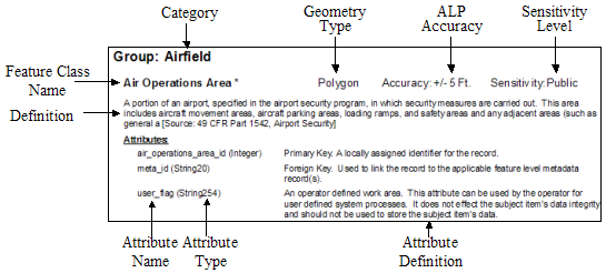
The feature types defined in this document are grouped into categories (i.e., Airfield, Airspace, Environmental, etc.) for ease of use. For each feature type, the class name, geometry type, sensitivity level, and a definition are provided. Suggested accuracies are also provided. Accuracies are indicated at a reasonable level that will meet a broad range of end user requirements. Individual project scopes, technical limitations and other factors may require data to be of a higher or lower level of accuracy. Attributes are also provided along with their type and definition. The following figure provides a key to the information provided within this Appendix.
Figure 1. Appendix 1 Legend
Data Set: Airfield
Airfield : Aircraft Gate Stand
(Database Feature Class Name = AircraftGateStand; FAA=AircraftGateStand)
Geometry Type: Point Accuracy: +/-3Ft. Sensitivity: Restricted
Geographic position of painted stand positions on the stand guidance line usually marked by a yellow crossbar according to aircraft type (e.g., for B-747, A-340).
Names and Identifiers:
id (String40) A unique identifier used by people to refer to this feature (note: this is not a system primary or foreign key value)
name (String50) The name of the feature.
alias (String60) An alternative or former name by which the feature is referred.
Attributes:
description (String255) Description of the feature.
gateStandType (CodeGateStandType) The type of aircraft gate/stand.
wingspan (Integer) The quantity representing the maximum wingspan which can be accommodated at the aircraft gate stand.
length (Integer) The overall length of the aircraft gate stand.
width (Integer) The overall width of the aircraft gate stand.
pavementClassificationNumber (String10) A number which expresses the relative load carrying capacity of a pavement in terms of a standard single wheel load.[AC 150/5335-5A].
jetwayAvailability (CodeBoolean) Indicates if a jetway or passenger loading bridge is available for use at the designated location.
towingAvailability (CodeBoolean) Indicates if towing is available at the designated location.
dockingAvailability (CodeBoolean) Indicates if docking light system is available at the designated location.
groundPowerAvailability (CodeBoolean) Indicates the availability of ground power at the designated location.
surfaceType (CodeSurfaceType) A classification of airfield pavement surfaces for Airport Obstruction Charts[NGS].
surfaceCondition (CodeSurfaceCondition) A description of the serviceability of the pavement[NFDC].
Metadata:
projectType (CodeProjectType) The type of project or work activity that installed or first recorded the location of this feature.
projectId (String20) A unique identifier associated with the project or work activity that installed or first recorded the location of this feature.
status (CodeStatus) A temporal description of the operational status of the feature.
Alternative (Integer) Discriminator used to tie features of a plan or proposal together into a version.
userFlag (String254) An operator defined work area. This attribute can be used by the operator for user defined system processes. It does not affect the subject items data integrity and should not be used to store the subject items data.[SDSFIE].
dataSource (CodeDataSource) The source of the data in this record.
sourceStatement (String255) A statement providing additional details about the source of the data.
editorName (String50) The name of the individual who last edited this data.
lastUpdate (Date) The date upon which any data associated with this record was last updated.
System Keys:
guid (String60) A globally unique identifier applied to each feature in the database for reference.
metaId (Integer) An identifier used to refer to a metadata record that provide additional information about the data in this record.
Airfield : Aircraft Non Movement Area
(Database Feature Class Name = AircraftNonMovementArea; FAA=AircraftNonMovementArea)
Geometry Type: Line Accuracy: +/-3Ft. Sensitivity: Restricted
Taxiways and apron (ramp) areas not under the control of air traffic.
Names and Identifiers:
id (String40) A unique identifier used by people to refer to this feature (note: this is not a system primary or foreign key value)
name (String50) The name of the feature.
alias (String60) An alternative or former name by which the feature is referred.
Attributes:
description (String255) Description of the feature.
Metadata:
projectType (CodeProjectType) The type of project or work activity that installed or first recorded the location of this feature.
projectId (String20) A unique identifier associated with the project or work activity that installed or first recorded the location of this feature.
status (CodeStatus) A temporal description of the operational status of the feature.
Alternative (Integer) Discriminator used to tie features of a plan or proposal together into a version.
userFlag (String254) An operator defined work area. This attribute can be used by the operator for user defined system processes. It does not affect the subject items data integrity and should not be used to store the subject items data.[SDSFIE].
dataSource (CodeDataSource) The source of the data in this record.
sourceStatement (String255) A statement providing additional details about the source of the data.
editorName (String50) The name of the individual who last edited this data.
lastUpdate (Date) The date upon which any data associated with this record was last updated.
System Keys:
guid (String60) A globally unique identifier applied to each feature in the database for reference.
metaId (Integer) An identifier used to refer to a metadata record that provide additional information about the data in this record.
Airfield : Airfield Light
(Database Feature Class Name = AirfieldLight; FAA=AirfieldLight)
Geometry Type: Point Accuracy: +/-3Ft. Sensitivity: Restricted
Not used, use Electrical Light. Any lighting located within or near an airport boundary that provides guidance for airborne and ground maneuvering of aircraft. [AIM, AC 150/5340-24].
Names and Identifiers:
id (String40) A unique identifier used by people to refer to this feature (note: this is not a system primary or foreign key value)
name (String50) Use this attribute to identify the use of the light such as Runway Edge Light, Taxiway Edge Light, Taxiway Centerline Light, etc.
alias (String60) An alternative or former name by which the feature is referred.
Attributes:
description (String255) Description of the feature
lightingType (CodeLightingConfigurationType) A description of the lighting system. Lighting system classifications are Approach; Airport; Runway; Taxiway; and Obstruction
color (CodeColor) The color of the airfield light.
luminescence (Integer) The luminescence of the airfield light specified in candellas (cd).
pilotControlFrequency (Real) The radio frequency used by pilots to control various airport lighting systems
Metadata:
projectType (CodeProjectType) The type of project or work activity that installed or first recorded the location of this feature.
projectId (String20) A unique identifier associated with the project or work activity that installed or first recorded the location of this feature.
status (CodeStatus) A temporal description of the operational status of the feature.
Alternative (Integer) Discriminator used to tie features of a plan or proposal together into a version.
userFlag (String254) An operator defined work area. This attribute can be used by the operator for user defined system processes. It does not affect the subject items data integrity and should not be used to store the subject items data.[SDSFIE].
dataSource (CodeDataSource) The source of the data in this record.
sourceStatement (String255) A statement providing additional details about the source of the data.
editorName (String50) The name of the individual who last edited this data.
lastUpdate (Date) The date upon which any data associated with this record was last updated.
System Keys:
guid (String60) A globally unique identifier applied to each feature in the database for reference.
metaId (Integer) An identifier used to refer to a metadata record that provide additional information about the data in this record.
Airfield : Air Operations Area
(Database Feature Class Name = AirOperationsArea; FAA=AirOperationsArea)
Geometry Type: Polygon Accuracy: +/-3Ft. Sensitivity: Unclassified
Air Operations Area is where security measures are enforced as specified in the airport security program. This area includes aircraft movement areas, aircraft parking areas, loading ramps, and safety areas and any adjacent areas (such as general aviation [49 CFR Part 1542, Airport Security*].
Names and Identifiers:
id (String40) A unique identifier used by people to refer to this feature (note: this is not a system primary or foreign key value)
name (String50) The name of the feature.
alias (String60) An alternative or former name by which the feature is referred.
Attributes:
description (String255) Description of the feature
Metadata:
projectType (CodeProjectType) The type of project or work activity that installed or first recorded the location of this feature.
projectId (String20) A unique identifier associated with the project or work activity that installed or first recorded the location of this feature.
status (CodeStatus) A temporal description of the operational status of the feature.
Alternative (Integer) Discriminator used to tie features of a plan or proposal together into a version.
userFlag (String254) An operator defined work area. This attribute can be used by the operator for user defined system processes. It does not affect the subject items data integrity and should not be used to store the subject items data.[SDSFIE].
dataSource (CodeDataSource) The source of the data in this record.
sourceStatement (String255) A statement providing additional details about the source of the data.
editorName (String50) The name of the individual who last edited this data.
lastUpdate (Date) The date upon which any data associated with this record was last updated.
System Keys:
guid (String60) A globally unique identifier applied to each feature in the database for reference.
metaId (Integer) An identifier used to refer to a metadata record that provide additional information about the data in this record.
Airfield : Airport Sign
(Database Feature Class Name = AirportSign; FAA=AirportSign)
Geometry Type: Point Accuracy: +/-3Ft. Sensitivity: Restricted
Signs at an airport other than surface painted signs. [AC 150/5340-18].
Names and Identifiers:
id (String40) A unique identifier used by people to refer to this feature (note: this is not a system primary or foreign key value)
name (String50) The name of the feature.
alias (String60) An alternative or former name by which the feature is referred.
Attributes:
description (String255) A description of the improvement feature.
signType (CodeSignTypeCode) The type of sign.
height (Real) The overall height of the feature.
message (String254) The text message that appears on the sign.
Metadata:
projectType (CodeProjectType) The type of project or work activity that installed or first recorded the location of this feature.
projectId (String20) A unique identifier associated with the project or work activity that installed or first recorded the location of this feature.
status (CodeStatus) A temporal description of the operational status of the feature.
Alternative (Integer) Discriminator used to tie features of a plan or proposal together into a version.
userFlag (String254) An operator defined work area. This attribute can be used by the operator for user defined system processes. It does not affect the subject items data integrity and should not be used to store the subject items data.[SDSFIE].
dataSource (CodeDataSource) The source of the data in this record.
sourceStatement (String255) A statement providing additional details about the source of the data.
editorName (String50) The name of the individual who last edited this data.
lastUpdate (Date) The date upon which any data associated with this record was last updated.
System Keys:
guid (String60) A globally unique identifier applied to each feature in the database for reference.
metaId (Integer) An identifier used to refer to a metadata record that provide additional information about the data in this record.
Airfield : Apron
(Database Feature Class Name = Apron; FAA=Apron)
Geometry Type: Polygon Accuracy: +/-3Ft. Sensitivity: Restricted
A defined area on an airport or heliport, paved or unpaved, intended to accommodate aircraft for purposes of loading or unloading passengers or cargo, refueling, parking, or maintenance. [FAA].
Names and Identifiers:
id (String40) A unique identifier used by people to refer to this feature (note: this is not a system primary or foreign key value)
name (String50) The name of the feature.
alias (String60) An alternative or former name by which the feature is referred.
Attributes:
description (String255) Description of the feature
apronType (CodeApronType) A classification of the typical use for the apron
numberOfTiedowns (Integer) The approximate number of tiedowns in the surface.
surfaceType (CodeSurfaceType) A classification of airfield pavement surfaces for Airport Obstruction Charts[NGS].
surfaceMaterial (CodeSurfaceMaterial) A code indicating the composition of the related surface[NFDC].
surfaceCondition (CodeSurfaceCondition) A description of the serviceability of the pavement[NFDC].
pavementClassificationNumber (String10) A number that expresses the relative load-carrying capacity of a pavement in terms of a standard single wheel load[AC 150/5335-5A].
fuel (CodeFuel) Code indicating the types of fuel available at the apron or deliverable to the apron.
Metadata:
projectType (CodeProjectType) The type of project or work activity that installed or first recorded the location of this feature.
projectId (String20) A unique identifier associated with the project or work activity that installed or first recorded the location of this feature.
status (CodeStatus) A temporal description of the operational status of the feature.
Alternative (Integer) Discriminator used to tie features of a plan or proposal together into a version.
userFlag (String254) An operator defined work area. This attribute can be used by the operator for user defined system processes. It does not affect the subject items data integrity and should not be used to store the subject items data.[SDSFIE].
dataSource (CodeDataSource) The source of the data in this record.
sourceStatement (String255) A statement providing additional details about the source of the data.
editorName (String50) The name of the individual who last edited this data.
lastUpdate (Date) The date upon which any data associated with this record was last updated.
System Keys:
guid (String60) A globally unique identifier applied to each feature in the database for reference.
metaId (Integer) An identifier used to refer to a metadata record that provide additional information about the data in this record.
Airfield : Arresting Gear
(Database Feature Class Name = ArrestingGear; FAA=ArrestingGear)
Geometry Type: Line Accuracy: +/-3Ft. Sensitivity: Restricted
Location of the arresting gear cable across the runway. [RTCA DO-272].
Names and Identifiers:
id (String40) A unique identifier used by people to refer to this feature (note: this is not a system primary or foreign key value)
name (String50) The name of the feature.
alias (String60) An alternative or former name by which the feature is referred.
Attributes:
description (String255) Description of the feature
airportFacilityType (CodeOperationsType) Type of airfield.
owner (Enumeration60) A person, organization, or agency with legal control or management responsibility of the utility asset.[Adopted from SDSFIE].
Metadata:
projectType (CodeProjectType) The type of project or work activity that installed or first recorded the location of this feature.
projectId (String20) A unique identifier associated with the project or work activity that installed or first recorded the location of this feature.
status (CodeStatus) A temporal description of the operational status of the feature.
Alternative (Integer) Discriminator used to tie features of a plan or proposal together into a version.
userFlag (String254) An operator defined work area. This attribute can be used by the operator for user defined system processes. It does not affect the subject items data integrity and should not be used to store the subject items data.[SDSFIE].
dataSource (CodeDataSource) The source of the data in this record.
sourceStatement (String255) A statement providing additional details about the source of the data.
editorName (String50) The name of the individual who last edited this data.
lastUpdate (Date) The date upon which any data associated with this record was last updated.
System Keys:
guid (String60) A globally unique identifier applied to each feature in the database for reference.
metaId (Integer) An identifier used to refer to a metadata record that provide additional information about the data in this record.
Airfield : Deicing Area
(Database Feature Class Name = DeicingArea; FAA=DeicingArea)
Geometry Type: Polygon Accuracy: +/-3Ft. Sensitivity: Unclassified
An aircraft deicing facility is a facility where: (1) frost, ice, or snow is removed (deicing) from the aircraft in order to provide clean surfaces and/or (2) clean surfaces of the aircraft receive protection (anti-icing) against the formation of frost or [AC 150/5300-13*].
Names and Identifiers:
id (String40) A unique identifier used by people to refer to this feature (note: this is not a system primary or foreign key value)
name (String50) The name of the feature.
alias (String60) An alternative or former name by which the feature is referred.
Attributes:
description (String255) A brief description of the area and any special characteristics.
Metadata:
projectType (CodeProjectType) The type of project or work activity that installed or first recorded the location of this feature.
projectId (String20) A unique identifier associated with the project or work activity that installed or first recorded the location of this feature.
status (CodeStatus) A temporal description of the operational status of the feature.
Alternative (Integer) Discriminator used to tie features of a plan or proposal together into a version.
userFlag (String254) An operator defined work area. This attribute can be used by the operator for user defined system processes. It does not affect the subject items data integrity and should not be used to store the subject items data.[SDSFIE].
dataSource (CodeDataSource) The source of the data in this record.
sourceStatement (String255) A statement providing additional details about the source of the data.
editorName (String50) The name of the individual who last edited this data.
lastUpdate (Date) The date upon which any data associated with this record was last updated.
System Keys:
guid (String60) A globally unique identifier applied to each feature in the database for reference.
metaId (Integer) An identifier used to refer to a metadata record that provide additional information about the data in this record.
Airfield : Frequency Area
(Database Feature Class Name = FrequencyArea; FAA=FrequencyArea)
Geometry Type: Polygon Accuracy: +/-3Ft. Sensitivity: Unclassified
Area specifying the designated part of the surface movement area where a specific frequency is required by ATC or ground control. If there is only one frequency area for the airport, the polygon must cover the total air operations area. [RTCA DO-272].
Names and Identifiers:
id (String40) A unique identifier used by people to refer to this feature (note: this is not a system primary or foreign key value)
name (String50) The name of the feature.
alias (String60) An alternative or former name by which the feature is referred.
Attributes:
description (String255) Description of the feature
station (String30) Service or Station assigned to primary frequency (e.g., ATC Tower, Ground Control)[RTCA DO-272].
frequency (Real) Primary frequency used on frequency area (in MHZ).[RTCA DO-272].
Metadata:
projectType (CodeProjectType) The type of project or work activity that installed or first recorded the location of this feature.
projectId (String20) A unique identifier associated with the project or work activity that installed or first recorded the location of this feature.
status (CodeStatus) A temporal description of the operational status of the feature.
Alternative (Integer) Discriminator used to tie features of a plan or proposal together into a version.
userFlag (String254) An operator defined work area. This attribute can be used by the operator for user defined system processes. It does not affect the subject items data integrity and should not be used to store the subject items data.[SDSFIE].
dataSource (CodeDataSource) The source of the data in this record.
sourceStatement (String255) A statement providing additional details about the source of the data.
editorName (String50) The name of the individual who last edited this data.
lastUpdate (Date) The date upon which any data associated with this record was last updated.
System Keys:
guid (String60) A globally unique identifier applied to each feature in the database for reference.
metaId (Integer) An identifier used to refer to a metadata record that provide additional information about the data in this record.
Airfield : Marking Area
(Database Feature Class Name = MarkingArea; FAA=MarkingArea)
Geometry Type: Polygon Accuracy: +/-2Ft. Sensitivity: Unclassified
Markings used on runway and taxiway surfaces to identify a specific runway, a runway threshold, a centerline, a hold line, etc. An element of marking whose geometry is a polygon. [AC 150/5340-1 and RTCA DO-272].
Names and Identifiers:
id (String40) A unique identifier used by people to refer to this feature (note: this is not a system primary or foreign key value)
name (String50) Name of the feature.
alias (String60) An alternative or former name by which the feature is referred.
Attributes:
description (String255) A description of the feature.
markingFeatureType (CodeMarkingFeatureType) The type of the marking
color (CodeColor) The color of the marking
Metadata:
projectType (CodeProjectType) The type of project or work activity that installed or first recorded the location of this feature.
projectId (String20) A unique identifier associated with the project or work activity that installed or first recorded the location of this feature.
status (CodeStatus) A temporal description of the operational status of the feature.
Alternative (Integer) Discriminator used to tie features of a plan or proposal together into a version.
userFlag (String254) An operator defined work area. This attribute can be used by the operator for user defined system processes. It does not affect the subject items data integrity and should not be used to store the subject items data.[SDSFIE].
dataSource (CodeDataSource) The source of the data in this record.
sourceStatement (String255) A statement providing additional details about the source of the data.
editorName (String50) The name of the individual who last edited this data.
lastUpdate (Date) The date upon which any data associated with this record was last updated.
System Keys:
guid (String60) A globally unique identifier applied to each feature in the database for reference.
metaId (Integer) An identifier used to refer to a metadata record that provide additional information about the data in this record.
Airfield : Marking Line
(Database Feature Class Name = MarkingLine; FAA=MarkingLine)
Geometry Type: Line Accuracy: +/-2Ft. Sensitivity: Restricted
Markings used on runway and taxiway surfaces to identify a specific runway, a runway threshold, a centerline, a hold line, etc. An element of marking whose geometry is a line. [AC 150/5340-1, RTCA/DO-272].
Names and Identifiers:
id (String40) A unique identifier used by people to refer to this feature (note: this is not a system primary or foreign key value)
name (String50) Name of the feature.
alias (String60) An alternative or former name by which the feature is referred.
Attributes:
description (String255) A description of the feature.
markingFeatureType (CodeMarkingFeatureType) The type of the marking
color (CodeColor) The color of the marking
Metadata:
projectType (CodeProjectType) The type of project or work activity that installed or first recorded the location of this feature.
projectId (String20) A unique identifier associated with the project or work activity that installed or first recorded the location of this feature.
status (CodeStatus) A temporal description of the operational status of the feature.
Alternative (Integer) Discriminator used to tie features of a plan or proposal together into a version.
userFlag (String254) An operator defined work area. This attribute can be used by the operator for user defined system processes. It does not affect the subject items data integrity and should not be used to store the subject items data.[SDSFIE].
dataSource (CodeDataSource) The source of the data in this record.
sourceStatement (String255) A statement providing additional details about the source of the data.
editorName (String50) The name of the individual who last edited this data.
lastUpdate (Date) The date upon which any data associated with this record was last updated.
System Keys:
guid (String60) A globally unique identifier applied to each feature in the database for reference.
metaId (Integer) An identifier used to refer to a metadata record that provide additional information about the data in this record.
Airfield : Movement Area
(Database Feature Class Name = MovementArea; FAA=MovementArea)
Geometry Type: Polygon Accuracy: +/-3Ft. Sensitivity: Restricted
Runways, taxiways, and other areas of an airport used for taxiing or hover taxiing, air taxiing, takeoff, and landing of aircraft, exclusive of loading ramps and aircraft parking areas. [14 CFR Part 139].
Names and Identifiers:
id (String40) A unique identifier used by people to refer to this feature (note: this is not a system primary or foreign key value)
alias (String60) An alternative or former name by which the feature is referred.
Attributes:
name (String50) Name of the feature
description (String255) Description of the feature
Metadata:
projectType (CodeProjectType) The type of project or work activity that installed or first recorded the location of this feature.
projectId (String20) A unique identifier associated with the project or work activity that installed or first recorded the location of this feature.
status (CodeStatus) A temporal description of the operational status of the feature.
Alternative (Integer) Discriminator used to tie features of a plan or proposal together into a version.
userFlag (String254) An operator defined work area. This attribute can be used by the operator for user defined system processes. It does not affect the subject items data integrity and should not be used to store the subject items data.[SDSFIE].
dataSource (CodeDataSource) The source of the data in this record.
sourceStatement (String255) A statement providing additional details about the source of the data.
editorName (String50) The name of the individual who last edited this data.
lastUpdate (Date) The date upon which any data associated with this record was last updated.
System Keys:
guid (String60) A globally unique identifier applied to each feature in the database for reference.
metaId (Integer) An identifier used to refer to a metadata record that provide additional information about the data in this record.
Airfield : Passenger Loading Bridge
(Database Feature Class Name = PassengerLoadingBridge; FAA=PassengerLoadingBridge)
Geometry Type: Polygon Accuracy: +/-3Ft. Sensitivity: Restricted
A bridge for loading/unloading access to airplanes for passengers and crew.
Names and Identifiers:
id (String40) A unique identifier used by people to refer to this feature (note: this is not a system primary or foreign key value)
name (String50) Name, code or identifier used to identify the loading bridge.
alias (String60) An alternative or former name by which the feature is referred.
Attributes:
description (String255) Description of the feature
loadingBridgeType (CodeLoadingBridgeType) Code indicating the type of loading bridge.
Metadata:
projectType (CodeProjectType) The type of project or work activity that installed or first recorded the location of this feature.
projectId (String20) A unique identifier associated with the project or work activity that installed or first recorded the location of this feature.
status (CodeStatus) A temporal description of the operational status of the feature.
Alternative (Integer) Discriminator used to tie features of a plan or proposal together into a version.
userFlag (String254) An operator defined work area. This attribute can be used by the operator for user defined system processes. It does not affect the subject items data integrity and should not be used to store the subject items data.[SDSFIE].
dataSource (CodeDataSource) The source of the data in this record.
sourceStatement (String255) A statement providing additional details about the source of the data.
editorName (String50) The name of the individual who last edited this data.
lastUpdate (Date) The date upon which any data associated with this record was last updated.
System Keys:
guid (String60) A globally unique identifier applied to each feature in the database for reference.
metaId (Integer) An identifier used to refer to a metadata record that provide additional information about the data in this record.
Airfield : Restricted Access Boundary
(Database Feature Class Name = RestrictedAccessBoundary; FAA=RestrictedAccessBoundary)
Geometry Type: Line Accuracy: +/-3Ft. Sensitivity: Confidential
A restricted area boundary identifies areas strictly reserved for use by authorized personnel only. [NGS*].
Names and Identifiers:
id (String40) A unique identifier used by people to refer to this feature (note: this is not a system primary or foreign key value)
name (String50) A common name for the restricted area.
alias (String60) An alternative or former name by which the feature is referred.
Attributes:
description (String255) A description of the restricted area.
Metadata:
projectType (CodeProjectType) The type of project or work activity that installed or first recorded the location of this feature.
projectId (String20) A unique identifier associated with the project or work activity that installed or first recorded the location of this feature.
status (CodeStatus) A temporal description of the operational status of the feature.
Alternative (Integer) Discriminator used to tie features of a plan or proposal together into a version.
userFlag (String254) An operator defined work area. This attribute can be used by the operator for user defined system processes. It does not affect the subject items data integrity and should not be used to store the subject items data.[SDSFIE].
dataSource (CodeDataSource) The source of the data in this record.
sourceStatement (String255) A statement providing additional details about the source of the data.
editorName (String50) The name of the individual who last edited this data.
lastUpdate (Date) The date upon which any data associated with this record was last updated.
System Keys:
guid (String60) A globally unique identifier applied to each feature in the database for reference.
metaId (Integer) An identifier used to refer to a metadata record that provide additional information about the data in this record.
Airfield : Runway
(Database Feature Class Name = Runway; FAA=Runway)
Geometry Type: Polygon Accuracy: +/-3Ft. Sensitivity: Restricted
A rectangular area on a airport prepared for the landing and takeoff run of aircraft. [AC 150/5300-13*].
Names and Identifiers:
id (String40) A unique identifier used by people to refer to this feature (note: this is not a system primary or foreign key value)
name (String50) Name of the feature.
alias (String60) An alternative or former name by which the feature is referred.
runwayDesignator (String7) Designator of the runway based on the magnetic bearing and position in relation to parallel runways (e.g. 33R/15L)[AC 150/5340-1].
Attributes:
description (String255) Description of the feature
width (Real) A perpendicular line to the surface centerline, extending to the edge of the runway pavement on both sides of the runway, through a runway end-point. If the runway width is less than 100 feet, the width is rounded up to the nearest 5 feet. If the runway w[NGS].
length (Real) The straight line distance between runway end points. This line does not account for surface undulations between points. Official runway lengths are normally computed from runway end coordinates and elevations.
surfaceType (CodeSurfaceType) A classification of airfield pavement surfaces for Airport Obstruction Charts[NGS].
surfaceMaterial (CodeSurfaceMaterial) A code indicating the composition of the related surface[NFDC].
pavementClassificationNumber (String10) A number that expresses the relative load carrying capacity of a pavement in terms of a standard single wheel load[AC 150/5335-5A].
surfaceCondition (CodeSurfaceCondition) A description of the serviceability of the pavement[NFDC].
Metadata:
projectType (CodeProjectType) The type of project or work activity that installed or first recorded the location of this feature.
projectId (String20) A unique identifier associated with the project or work activity that installed or first recorded the location of this feature.
status (CodeStatus) A temporal description of the operational status of the feature.
Alternative (Integer) Discriminator used to tie features of a plan or proposal together into a version.
userFlag (String254) An operator defined work area. This attribute can be used by the operator for user defined system processes. It does not affect the subject items data integrity and should not be used to store the subject items data.[SDSFIE].
dataSource (CodeDataSource) The source of the data in this record.
sourceStatement (String255) A statement providing additional details about the source of the data.
editorName (String50) The name of the individual who last edited this data.
lastUpdate (Date) The date upon which any data associated with this record was last updated.
System Keys:
guid (String60) A globally unique identifier applied to each feature in the database for reference.
metaId (Integer) An identifier used to refer to a metadata record that provide additional information about the data in this record.
Airfield : Runway Arresting Area
(Database Feature Class Name = RunwayArrestingArea; FAA=RunwayArrestingArea)
Geometry Type: Polygon Accuracy: +/-3Ft. Sensitivity: Restricted
Any FAA-approved high energy absorbing material of a specific strength that will reliably and predictably bring an aircraft to a stop without imposing loads that exceed the aircraft's design limits, cause major structural damage, or impose excessive force [AC 150/5220-22*].
Names and Identifiers:
id (String40) A unique identifier used by people to refer to this feature (note: this is not a system primary or foreign key value)
name (String50) A common name for the arresting area.
alias (String60) An alternative or former name by which the feature is referred.
Attributes:
description (String255) A description of the arresting area.
length (Real) The overall length of the feature.
width (Real) The overall width of the feature.
surfaceMaterial (CodeSurfaceMaterial) A code indicating the composition of the related surface[NFDC].
surfaceCondition (CodeSurfaceCondition) A description of the serviceability of the pavement[NFDC].
Setback (Integer) The distance the EMAS begins beyond the end of the runway.
Metadata:
projectType (CodeProjectType) The type of project or work activity that installed or first recorded the location of this feature.
projectId (String20) A unique identifier associated with the project or work activity that installed or first recorded the location of this feature.
status (CodeStatus) A temporal description of the operational status of the feature.
Alternative (Integer) Discriminator used to tie features of a plan or proposal together into a version.
userFlag (String254) An operator defined work area. This attribute can be used by the operator for user defined system processes. It does not affect the subject items data integrity and should not be used to store the subject items data.[SDSFIE].
dataSource (CodeDataSource) The source of the data in this record.
sourceStatement (String255) A statement providing additional details about the source of the data.
editorName (String50) The name of the individual who last edited this data.
lastUpdate (Date) The date upon which any data associated with this record was last updated.
System Keys:
guid (String60) A globally unique identifier applied to each feature in the database for reference.
metaId (Integer) An identifier used to refer to a metadata record that provide additional information about the data in this record.
Airfield : Blast Pad
(Database Feature Class Name = RunwayBlastPad; FAA=RunwayBlastPad)
Geometry Type: Polygon Accuracy: +/-2Ft. Sensitivity: Restricted
A specially prepared surface placed adjacent to the ends of runways to eliminate the erosive effect of the high wind forces produced by airplanes at the beginning of their takeoff rolls. [AC 150/5300-13].
Names and Identifiers:
id (String40) A unique identifier used by people to refer to this feature (note: this is not a system primary or foreign key value)
name (String50) Name of the feature.
alias (String60) An alternative or former name by which the feature is referred.
Attributes:
description (String255) Description of the feature
length (Integer) The length of clearway as measured. Compare the measure value to the value reported in the government flight information publications.
pavementClassificationNumber (String10) A number that expresses the relative load carrying capacity of a pavement in terms of a standard single wheel load[AC 150/5335-5A].
runwayEndDesignator (String3) Specify runwayEnd designator to identify which runway end the Blast Pad is on.
surfaceCondition (CodeSurfaceCondition) A description of the serviceability of the pavement[NFDC].
surfaceMaterial (CodeSurfaceMaterial) A code indicating the composition of the related surface[NFDC].
surfaceType (CodeSurfaceType) A classification of airfield pavement surfaces for Airport Obstruction Charts[NGS].
Metadata:
projectType (CodeProjectType) The type of project or work activity that installed or first recorded the location of this feature.
projectId (String20) A unique identifier associated with the project or work activity that installed or first recorded the location of this feature.
status (CodeStatus) A temporal description of the operational status of the feature.
Alternative (Integer) Discriminator used to tie features of a plan or proposal together into a version.
userFlag (String254) An operator defined work area. This attribute can be used by the operator for user defined system processes. It does not affect the subject items data integrity and should not be used to store the subject items data.[SDSFIE].
dataSource (CodeDataSource) The source of the data in this record.
sourceStatement (String255) A statement providing additional details about the source of the data.
editorName (String50) The name of the individual who last edited this data.
lastUpdate (Date) The date upon which any data associated with this record was last updated.
System Keys:
guid (String60) A globally unique identifier applied to each feature in the database for reference.
metaId (Integer) An identifier used to refer to a metadata record that provide additional information about the data in this record.
Airfield : Runway Centerline
(Database Feature Class Name = RunwayCenterline; FAA=RunwayCenterline)
Geometry Type: Line Accuracy: +/-1Ft. Sensitivity: Restricted
Continuous line along the painted centerline of a runway connecting the middle-points of the two outermost thresholds. Centerline is composed of many centerline points (see RunwayControlPoint). It is used to calculate grade and line-of-sight criteria. [AC 150/5300-13].
Names and Identifiers:
id (String40) A unique identifier used by people to refer to this feature (note: this is not a system primary or foreign key value)
name (String50) The name of the feature.
runwayDesignator (String7) Designator of the runway based on the magnetic bearing and position in relation to parallel runways (e.g. 33R/15L)[AC 150/5340-1].
alias (String60) An alternative or former name by which the feature is referred.
Attributes:
description (String255) Description of the feature
Metadata:
isDerived (CodeBoolean) Indicates whether the centerline is derived or photo determined.
projectType (CodeProjectType) The type of project or work activity that installed or first recorded the location of this feature.
projectId (String20) A unique identifier associated with the project or work activity that installed or first recorded the location of this feature.
status (CodeStatus) A temporal description of the operational status of the feature.
Alternative (Integer) Discriminator used to tie features of a plan or proposal together into a version.
userFlag (String254) An operator defined work area. This attribute can be used by the operator for user defined system processes. It does not affect the subject items data integrity and should not be used to store the subject items data.[SDSFIE].
dataSource (CodeDataSource) The source of the data in this record.
sourceStatement (String255) A statement providing additional details about the source of the data.
editorName (String50) The name of the individual who last edited this data.
lastUpdate (Date) The date upon which any data associated with this record was last updated.
System Keys:
guid (String60) A globally unique identifier applied to each feature in the database for reference.
metaId (Integer) An identifier used to refer to a metadata record that provide additional information about the data in this record.
Airfield : Runway Element
(Database Feature Class Name = RunwayElement; FAA=RunwayElement)
Geometry Type: Polygon Accuracy: +/-3Ft. Sensitivity: Restricted
A section of the runway surface. The runway surface can be defined by a set of non-overlapping RunwaySegment polygons for pavement management purposes. RunwayElements may overlap Runway and RunwayIntersection features. Use RunwayElement to model the physi [AC 150/5335-5, AC 150/5320-12, AC 150/5320-17, AC 150/5320-6].
Names and Identifiers:
id (String40) A unique identifier used by people to refer to this feature (note: this is not a system primary or foreign key value)
name (String50) The name of the feature.
alias (String60) An alternative or former name by which the feature is referred.
Attributes:
description (String255) Description of the feature
runwayDesignator (String7) Specify runway designator.
surfaceType (CodeSurfaceType) A classification of airfield pavement surfaces for Airport Obstruction Charts[NGS].
surfaceMaterial (CodeSurfaceMaterial) A code indicating the composition of the related surface[NFDC].
pavementClassificationNumber (String10) A number which expresses the relative load carrying capacity of a pavement in terms of a standard single wheel load.[AC 150/5335-5A].
surfaceCondition (CodeSurfaceCondition) A description of the serviceability of the pavement[NFDC].
Metadata:
projectType (CodeProjectType) The type of project or work activity that installed or first recorded the location of this feature.
projectId (String20) A unique identifier associated with the project or work activity that installed or first recorded the location of this feature.
status (CodeStatus) A temporal description of the operational status of the feature.
Alternative (Integer) Discriminator used to tie features of a plan or proposal together into a version.
userFlag (String254) An operator defined work area. This attribute can be used by the operator for user defined system processes. It does not affect the subject items data integrity and should not be used to store the subject items data.[SDSFIE].
dataSource (CodeDataSource) The source of the data in this record.
sourceStatement (String255) A statement providing additional details about the source of the data.
editorName (String50) The name of the individual who last edited this data.
lastUpdate (Date) The date upon which any data associated with this record was last updated.
System Keys:
guid (String60) A globally unique identifier applied to each feature in the database for reference.
metaId (Integer) An identifier used to refer to a metadata record that provide additional information about the data in this record.
Airfield : Runway End
(Database Feature Class Name = RunwayEnd; FAA=RunwayEnd)
Geometry Type: Point Accuracy: +/-1Ft. Sensitivity: Restricted
The end of the runway surface suitable for landing or takeoff runs of aircraft. Runway Ends describe the approach and departure procedure characteristics of a runway threshold. The Runway End is the same as the runway threshold when the threshold is not [NGS*].
Names and Identifiers:
id (String40) A unique identifier used by people to refer to this feature (note: this is not a system primary or foreign key value)
name (String50) Name of the feature.
alias (String60) An alternative or former name by which the feature is referred.
runwayEndDesignator (String3) The designator for the runway end (i.e. 32L)
Attributes:
description (String255) Description of the feature
ellipsoidHeight (Real) The height above the reference ellipsoid, measured along the ellipsoidal outer normal through the point in question. Also called the geodetic height.[NGS].
approachCategory (CodeApproachCategory) A grouping of aircraft based on 1.3 times their stall speed in the landing configuration at the certificated maximum flap setting and maximum landing weight at standard atmospheric conditions[AC 150/5300-13].
approachGuidance (CodeApproachGuidance) The type of approach guidance in use for the runway end.
accelerateStopDistanceAvail (Real) The runway plus stopway length declared available and suitable for the acceleration and deceleration of an airplane aborting a takeoff.[AC 150/5300-13].
magneticBearing (Real) Magnetic runway bearing corresponding to threshold location valid at the day of data generation[RTCA DO-272].
trueBearing (Real) True bearing corresponding to the landing direction[ICAO Annex 14].
designGroup (CodeDesignGroup) A grouping of airplanes based on wingspan and or tailheight, whichever is greatest.[AC 150/5300-13].
displacedDistance (Integer) The distance from the runway end to the landing threshold. When the thresholdType is normal, displacedDist = 0.
landingDistanceAvailable (Real) The runway length declared available and suitable for a landing airplane.[AC 150/5300-13].
runwaySlope (Real) Runway slope corresponding to landing direction.[RTCA DO-272].
takeOffDistanceAvailable (Real) The takeoff run available plus the length of any remaining runway clearway beyond the far end of the takeoff run available.[AC 150/5300-13].
takeOffRunwayAvailable (Real) The runway length declared available and suitable for the ground run of an airplane taking off[AC 150/5300-13].
touchdownZoneSlope (Real) The longitudinal slope of the first 3000 feet of the runway beginning at the threshold.[FAA Specification 405].
touchdownZoneElevation (Real) The highest elevation in the Touchdown Zone. The Touchdown Zone is the first 3,000 feet of the runway beginning at the threshold.[FAA Specification 405].
thresholdType (CodeThresholdType) An description of the landing threshold: either normal or displaced
Metadata:
projectType (CodeProjectType) The type of project or work activity that installed or first recorded the location of this feature.
projectId (String20) A unique identifier associated with the project or work activity that installed or first recorded the location of this feature.
status (CodeStatus) A temporal description of the operational status of the feature.
Alternative (Integer) Discriminator used to tie features of a plan or proposal together into a version.
userFlag (String254) An operator defined work area. This attribute can be used by the operator for user defined system processes. It does not affect the subject items data integrity and should not be used to store the subject items data.[SDSFIE].
dataSource (CodeDataSource) The source of the data in this record.
sourceStatement (String255) A statement providing additional details about the source of the data.
editorName (String50) The name of the individual who last edited this data.
lastUpdate (Date) The date upon which any data associated with this record was last updated.
System Keys:
guid (String60) A globally unique identifier applied to each feature in the database for reference.
metaId (Integer) An identifier used to refer to a metadata record that provide additional information about the data in this record.
Airfield : Runway Helipad Design Surface
(Database Feature Class Name = RunwayHelipadDesignSurface; FAA=RunwayHelipadDesignSurface)
Geometry Type: Polygon Accuracy: +/-Ft. Sensitivity: Restricted
A three-dimensional surface that is used in runway or heliport/helipad design. [AC 150/5300-13].
Names and Identifiers:
id (String40) A unique identifier used by people to refer to this feature (note: this is not a system primary or foreign key value)
name (String50) The name of the feature.[SDSFIE Feature Table].
alias (String60) An alternative or former name by which the feature is referred.
Attributes:
description (String255) Description of the feature
designSurfaceType (CodeDesignSurfaceType) A description of the design surface
zoneUse (String50) A description of the use of the zone.
determination (String255) A formal declaration of the runway/helipad/heliport safety area condition with respect to standards and any requirement improvements[FAA Order 5200.8 and AC 150/5390-2].
determinationDate (String8) The date the safety area determination was approved[FAA Order 5200.8 and AC 150/5390-2B].
zoneInnerWidth (Real) The width of the narrow end of a trapezoidal shaped DesignSurface feature. This is normally the end that is closest to the landing surface[AC 150/5300-13 and 150/5390-2B].
zoneOuterWidth (Real) The width of the wide end of a trapezoidal shaped DesignSurface feature. This is normally the end that is furthest from the landing surface.
zoneLength (Real) The length of a trapezoidal shaped DesignSurface feature.
slope (Real) The low to high gradient within the airspace.
Metadata:
projectType (CodeProjectType) The type of project or work activity that installed or first recorded the location of this feature.
projectId (String20) A unique identifier associated with the project or work activity that installed or first recorded the location of this feature.
status (CodeStatus) A temporal description of the operational status of the feature.
Alternative (Integer) Discriminator used to tie features of a plan or proposal together into a version.
userFlag (String254) An operator defined work area. This attribute can be used by the operator for user defined system processes. It does not affect the subject items data integrity and should not be used to store the subject items data.[SDSFIE].
dataSource (CodeDataSource) The source of the data in this record.
sourceStatement (String255) A statement providing additional details about the source of the data.
editorName (String50) The name of the individual who last edited this data.
lastUpdate (Date) The date upon which any data associated with this record was last updated.
System Keys:
guid (String60) A globally unique identifier applied to each feature in the database for reference.
metaId (Integer) An identifier used to refer to a metadata record that provide additional information about the data in this record.
Airfield : Runway Intersection
(Database Feature Class Name = RunwayIntersection; FAA=RunwayIntersection)
Geometry Type: Polygon Accuracy: +/-3Ft. Sensitivity: Confidential
The area in which two or more runways intersect.
Names and Identifiers:
id (String40) A unique identifier used by people to refer to this feature (note: this is not a system primary or foreign key value)
name (String50) The name of the feature.
alias (String60) An alternative or former name by which the feature is referred.
runwayDesignator1 (String7) Designator of the 1st intersecting runway based on the magnetic bearing and position in relation to parallel runways (e.g. 33R/15L).
runwayDesignator2 (String7) Designator of the 2nd intersecting runway based on the magnetic bearing and position in relation to parallel runways (e.g. 33R/15L).
runwayDesignator3 (String7) Designator of the 3rd intersecting runway based on the magnetic bearing and position in relation to parallel runways (e.g. 33R/15L).
Attributes:
description (String255) Description of the feature
pavementClassificationNumber (String10) A number which expresses the relative load carrying capacity of a pavement in terms of a standard single wheel load.[AC 150/5335-5A].
Metadata:
projectType (CodeProjectType) The type of project or work activity that installed or first recorded the location of this feature.
projectId (String20) A unique identifier associated with the project or work activity that installed or first recorded the location of this feature.
status (CodeStatus) A temporal description of the operational status of the feature.
Alternative (Integer) Discriminator used to tie features of a plan or proposal together into a version.
userFlag (String254) An operator defined work area. This attribute can be used by the operator for user defined system processes. It does not affect the subject items data integrity and should not be used to store the subject items data.[SDSFIE].
dataSource (CodeDataSource) The source of the data in this record.
sourceStatement (String255) A statement providing additional details about the source of the data.
editorName (String50) The name of the individual who last edited this data.
lastUpdate (Date) The date upon which any data associated with this record was last updated.
System Keys:
guid (String60) A globally unique identifier applied to each feature in the database for reference.
metaId (Integer) An identifier used to refer to a metadata record that provide additional information about the data in this record.
Airfield : Runway Label
(Database Feature Class Name = RunwayLabel; FAA=RunwayLabel)
Geometry Type: Point Accuracy: +/-3Ft. Sensitivity: Secret
The bottom center position of the runway designation marking. [NGS].
Names and Identifiers:
id (String40) A unique identifier used by people to refer to this feature (note: this is not a system primary or foreign key value)
name (String50) The name of the feature.
alias (String60) An alternative or former name by which the feature is referred.
runwayEndDesignator (String3) The designator of the associated runway
Attributes:
description (String255) Description of the feature.
Metadata:
projectType (CodeProjectType) The type of project or work activity that installed or first recorded the location of this feature.
projectId (String20) A unique identifier associated with the project or work activity that installed or first recorded the location of this feature.
status (CodeStatus) A temporal description of the operational status of the feature.
Alternative (Integer) Discriminator used to tie features of a plan or proposal together into a version.
userFlag (String254) An operator defined work area. This attribute can be used by the operator for user defined system processes. It does not affect the subject items data integrity and should not be used to store the subject items data.[SDSFIE].
dataSource (CodeDataSource) The source of the data in this record.
sourceStatement (String255) A statement providing additional details about the source of the data.
editorName (String50) The name of the individual who last edited this data.
lastUpdate (Date) The date upon which any data associated with this record was last updated.
System Keys:
guid (String60) A globally unique identifier applied to each feature in the database for reference.
metaId (Integer) An identifier used to refer to a metadata record that provide additional information about the data in this record.
Airfield : Land and Hold Short Line
(Database Feature Class Name = RunwayLAHSO; FAA=RunwayLAHSO)
Geometry Type: Line Accuracy: +/-3Ft. Sensitivity: Restricted
Markings installed on a runway where an aircraft is to stop when the runway is normally used as a taxiway or used for Land and Hold Short Operations (LAHSO) as identified in a letter of agreement with the Air Traffic Control Tower (ATCT). A runway should [Order 7110.118*].
Names and Identifiers:
id (String40) A unique identifier used by people to refer to this feature (note: this is not a system primary or foreign key value)
name (String50) The name of the feature.
alias (String60) An alternative or former name by which the feature is referred.
Attributes:
description (String255) Description of the feature
protectedRunwayDesignator (String7) Unique runway identifier for the airport of the runway, if any, being protected by the LAHSO (when the LAHSO precedes a runway intersection). Example 17L/35R.
markingFeatureType (CodeMarkingFeatureType) The type of the marking
color (CodeColor) The color of the marking
Metadata:
projectType (CodeProjectType) The type of project or work activity that installed or first recorded the location of this feature.
projectId (String20) A unique identifier associated with the project or work activity that installed or first recorded the location of this feature.
status (CodeStatus) A temporal description of the operational status of the feature.
Alternative (Integer) Discriminator used to tie features of a plan or proposal together into a version.
userFlag (String254) An operator defined work area. This attribute can be used by the operator for user defined system processes. It does not affect the subject items data integrity and should not be used to store the subject items data.[SDSFIE].
dataSource (CodeDataSource) The source of the data in this record.
sourceStatement (String255) A statement providing additional details about the source of the data.
editorName (String50) The name of the individual who last edited this data.
lastUpdate (Date) The date upon which any data associated with this record was last updated.
System Keys:
guid (String60) A globally unique identifier applied to each feature in the database for reference.
metaId (Integer) An identifier used to refer to a metadata record that provide additional information about the data in this record.
Airfield : Runway Safety Area Boundary
(Database Feature Class Name = RunwaySafetyAreaBoundary; FAA=RunwaySafetyAreaBoundary)
Geometry Type: Polygon Accuracy: +/-3Ft. Sensitivity: Restricted
The boundary of the Runway Safety Area (RSA). [AC 150/53XX-XX (Vol. C)].
Names and Identifiers:
id (String40) A unique identifier used by people to refer to this feature (note: this is not a system primary or foreign key value)
name (String50) The name of the feature.
alias (String60) An alternative or former name by which the feature is referred.
Attributes:
description (String255) Description of the feature.
runwayEndDesignator (String3) Specific runway end designator.[FAA AC150/5300-18b].
determinationDate (String8) Date the RSA determination was approved[FAA Order 5200.8].
determination (String255) A formal declaration of the runway safety area condition with respect to standards and any requirement improvements[FAA Order 5200.8].
Metadata:
projectType (CodeProjectType) The type of project or work activity that installed or first recorded the location of this feature.
projectId (String20) A unique identifier associated with the project or work activity that installed or first recorded the location of this feature.
status (CodeStatus) A temporal description of the operational status of the feature.
Alternative (Integer) Discriminator used to tie features of a plan or proposal together into a version.
userFlag (String254) An operator defined work area. This attribute can be used by the operator for user defined system processes. It does not affect the subject items data integrity and should not be used to store the subject items data.[SDSFIE].
dataSource (CodeDataSource) The source of the data in this record.
sourceStatement (String255) A statement providing additional details about the source of the data.
editorName (String50) The name of the individual who last edited this data.
lastUpdate (Date) The date upon which any data associated with this record was last updated.
System Keys:
guid (String60) A globally unique identifier applied to each feature in the database for reference.
metaId (Integer) An identifier used to refer to a metadata record that provide additional information about the data in this record.
Airfield : Shoulder
(Database Feature Class Name = Shoulder; FAA=Shoulder)
Geometry Type: Polygon Accuracy: +/-3Ft. Sensitivity: Restricted
An area adjacent to the edge of paved runways, taxiways, or aprons providing a transition between the pavement and the adjacent surface; support for aircraft running off the pavement; enhance drainage; and blast protection. [AC 150/5300-13].
Names and Identifiers:
id (String40) A unique identifier used by people to refer to this feature (note: this is not a system primary or foreign key value)
name (String50) The name of the feature.[AC 150/5300-18b].
alias (String60) An alternative or former name by which the feature is referred.
Attributes:
description (String255) Description of the feature.[AC 150/5300-18b].
shoulderType (CodeShoulderType) Code for whether this is a runway shoulder or taxiway shoulder[SDSFIE Attribute Table].
length (Real) The overall length of the airfield surface.[SDSFIE Attribute Table].
width (Real) The overall width of the airfield surface.[SDSFIE Feature Table].
restricted (CodeBoolean) An indicator as to whether access to the feature is restricted.
surfaceMaterial (CodeSurfaceMaterial) A code indicating the composition of the related surface[NFDC].
sequence (String5) Sequential number of the element.
surfaceCondition (CodeSurfaceCondition) A description of the serviceability of the pavement[NFDC].
surfaceType (CodeSurfaceType) A classification of airfield pavement surfaces for Airport Obstruction Charts[NGS].
Metadata:
projectType (CodeProjectType) The type of project or work activity that installed or first recorded the location of this feature.
projectId (String20) A unique identifier associated with the project or work activity that installed or first recorded the location of this feature.
status (CodeStatus) A temporal description of the operational status of the feature.
Alternative (Integer) Discriminator used to tie features of a plan or proposal together into a version.
userFlag (String254) An operator defined work area. This attribute can be used by the operator for user defined system processes. It does not affect the subject items data integrity and should not be used to store the subject items data.[SDSFIE].
dataSource (CodeDataSource) The source of the data in this record.
sourceStatement (String255) A statement providing additional details about the source of the data.
editorName (String50) The name of the individual who last edited this data.
lastUpdate (Date) The date upon which any data associated with this record was last updated.
System Keys:
guid (String60) A globally unique identifier applied to each feature in the database for reference.
metaId (Integer) An identifier used to refer to a metadata record that provide additional information about the data in this record.
Airfield : Stopway
(Database Feature Class Name = Stopway; FAA=Stopway)
Geometry Type: Polygon Accuracy: +/-3Ft. Sensitivity: Restricted
An area beyond the takeoff runway, no less wide than the runway and centered upon the extended centerline of the runway, able to support the airplane during an aborted takeoff without causing structural damage to the airplane. It is designated by the airp
Names and Identifiers:
id (String40) A unique identifier used by people to refer to this feature (note: this is not a system primary or foreign key value)
name (String50) The name of the feature.
alias (String60) An alternative or former name by which the feature is referred.
Attributes:
description (String255) Description of the feature
length (Real) The length of the designated stopway from the end of the runway
width (Real) The overall width of the feature
runwayEndDesignator (String3) Specify runwayEnd designator to identify which runway end the Stopway is on.
surfaceType (CodeSurfaceType) A classification of airfield pavement surfaces for Airport Obstruction Charts[NGS].
surfaceMaterial (CodeSurfaceMaterial) A code indicating the composition of the related surface[NFDC].
surfaceCondition (CodeSurfaceCondition) A description of the serviceability of the pavement[NFDC].
Metadata:
projectType (CodeProjectType) The type of project or work activity that installed or first recorded the location of this feature.
projectId (String20) A unique identifier associated with the project or work activity that installed or first recorded the location of this feature.
status (CodeStatus) A temporal description of the operational status of the feature.
Alternative (Integer) Discriminator used to tie features of a plan or proposal together into a version.
userFlag (String254) An operator defined work area. This attribute can be used by the operator for user defined system processes. It does not affect the subject items data integrity and should not be used to store the subject items data.[SDSFIE].
dataSource (CodeDataSource) The source of the data in this record.
sourceStatement (String255) A statement providing additional details about the source of the data.
editorName (String50) The name of the individual who last edited this data.
lastUpdate (Date) The date upon which any data associated with this record was last updated.
System Keys:
guid (String60) A globally unique identifier applied to each feature in the database for reference.
metaId (Integer) An identifier used to refer to a metadata record that provide additional information about the data in this record.
Airfield : Taxiway Element
(Database Feature Class Name = TaxiwayElement; FAA=TaxiwayElement)
Geometry Type: Polygon Accuracy: +/-3Ft. Sensitivity: Restricted
Defined paths on an airport established for the taxiing of aircraft (excluding apron taxilanes) and intended to provide a link between one part of the airport and another. [AC 150-5300-13].
Names and Identifiers:
id (String40) A unique identifier used by people to refer to this feature (note: this is not a system primary or foreign key value)
name (String50) Name of the feature.
taxiwayId (String50) Taxiway element name. The name should be identical to the corresponding taxiway name. Multiple taxiway elements can have the same name. If two or more taxiways intersect the taxiway element intersection will be named after the predominant taxiway. If two[FAA Airports GIS].
alias (String60) An alternative or former name by which the feature is referred.
Attributes:
description (String255) Description of the feature.[FGDC].
taxiwayType (CodeTaxiwayType) The type of taxiway.
surfaceMaterial (CodeSurfaceMaterial) A code indicating the composition of the related surface[NFDC].
pavementClassificationNumber (String10) A number which expresses the relative load carrying capacity of a pavement in terms of a standard single wheel load.[AC 150/5335-5A].
surfaceCondition (CodeSurfaceCondition) A description of the serviceability of the pavement[NFDC].
directionality (CodeDirectionality) Code used to define the directionality of traffic on the element.
sequence (String5) Sequential number of the taxiway element.
surfaceType (CodeSurfaceType) Type of different materials used to construct the surface.[NGS].
designGroup (CodeDesignGroup) Identifies the design group used in the design of the taxiway[AC 150/5300-13].
length (Real) Provides the length of the taxiwayElement polygon as measured along the centerline.[SDSFIE Feature Table].
width (Real) Width of the taxiway.[SDSFIE Feature Table].
maximumSpeed (Integer) Identifies the maximum speed for the taxiwayElement.
wingspan (Real) Identifies the maximum aircraft wingspan which can traverse the taxiwayElement.[SDSFIE Feature Table].
Metadata:
projectType (CodeProjectType) The type of project or work activity that installed or first recorded the location of this feature.
projectId (String20) A unique identifier associated with the project or work activity that installed or first recorded the location of this feature.
status (CodeStatus) A temporal description of the operational status of the feature.
Alternative (Integer) Discriminator used to tie features of a plan or proposal together into a version.
userFlag (String254) An operator defined work area. This attribute can be used by the operator for user defined system processes. It does not affect the subject items data integrity and should not be used to store the subject items data.[SDSFIE].
dataSource (CodeDataSource) The source of the data in this record.
sourceStatement (String255) A statement providing additional details about the source of the data.
editorName (String50) The name of the individual who last edited this data.
lastUpdate (Date) The date upon which any data associated with this record was last updated.
System Keys:
guid (String60) A globally unique identifier applied to each feature in the database for reference.
metaId (Integer) An identifier used to refer to a metadata record that provide additional information about the data in this record.
Airfield : Taxiway Holding Position
(Database Feature Class Name = TaxiwayHoldingPosition; FAA=TaxiwayHoldingPosition)
Geometry Type: Line Accuracy: +/-3Ft. Sensitivity: Restricted
A designated position at which taxiing aircraft and vehicles shall stop and hold position, unless otherwise authorized by the aerodrome control tower. [RTCA DO-272].
Names and Identifiers:
id (String40) A unique identifier used by people to refer to this feature (note: this is not a system primary or foreign key value)
name (String50) The name of the feature.
alias (String60) An alternative or former name by which the feature is referred.
runwayDesignator (String7) The designator for the approaching runway.
taxiwayDesignator (String4) The designator for the taxiway.
Attributes:
description (String255) A description of the feature.
lowVisibilityCategory (CodeLowVisibilityCategory) Code describing the Low visibility operation category of the TaxiwayHoldingPosition.
Metadata:
projectType (CodeProjectType) The type of project or work activity that installed or first recorded the location of this feature.
projectId (String20) A unique identifier associated with the project or work activity that installed or first recorded the location of this feature.
status (CodeStatus) A temporal description of the operational status of the feature.
Alternative (Integer) Discriminator used to tie features of a plan or proposal together into a version.
userFlag (String254) An operator defined work area. This attribute can be used by the operator for user defined system processes. It does not affect the subject items data integrity and should not be used to store the subject items data.[SDSFIE].
dataSource (CodeDataSource) The source of the data in this record.
sourceStatement (String255) A statement providing additional details about the source of the data.
editorName (String50) The name of the individual who last edited this data.
lastUpdate (Date) The date upon which any data associated with this record was last updated.
System Keys:
guid (String60) A globally unique identifier applied to each feature in the database for reference.
metaId (Integer) An identifier used to refer to a metadata record that provide additional information about the data in this record.
Airfield : Taxiway Intersection
(Database Feature Class Name = TaxiwayIntersection; FAA=TaxiwayIntersection)
Geometry Type: Polygon Accuracy: +/-3Ft. Sensitivity: Restricted
A junction of two or more taxiways (Source: ICAO Annex 14, Volume 1, Aerodromes, Chapter 1, page 5). [ICAO Annex 14 (Aerodromes), Chapter 1, page 5].
Names and Identifiers:
id (String40) A unique identifier used by people to refer to this feature (note: this is not a system primary or foreign key value)
name (String40) The name of the feature.
alias (String60) An alternative or former name by which the feature is referred.
Attributes:
description (String255) Description of the feature.
Metadata:
projectType (CodeProjectType) The type of project or work activity that installed or first recorded the location of this feature.
projectId (String20) A unique identifier associated with the project or work activity that installed or first recorded the location of this feature.
status (CodeStatus) A temporal description of the operational status of the feature.
Alternative (Integer) Discriminator used to tie features of a plan or proposal together into a version.
userFlag (String254) An operator defined work area. This attribute can be used by the operator for user defined system processes. It does not affect the subject items data integrity and should not be used to store the subject items data.[SDSFIE].
dataSource (CodeDataSource) The source of the data in this record.
sourceStatement (String255) A statement providing additional details about the source of the data.
editorName (String50) The name of the individual who last edited this data.
lastUpdate (Date) The date upon which any data associated with this record was last updated.
System Keys:
guid (String60) A globally unique identifier applied to each feature in the database for reference.
metaId (Integer) An identifier used to refer to a metadata record that provide additional information about the data in this record.
Airfield : Touchdown Lift Off
(Database Feature Class Name = TouchdownLiftOff; FAA=TouchDownLiftOff)
Geometry Type: Polygon Accuracy: +/-1Ft. Sensitivity: Unclassified
A load-bearing, generally paved area, normally centered in the Final Approach and Takeoff Area (FATO), on which a helicopter lands or takes off. The Touchdown and Lift-off Area (TLOF) is frequently called a helipad or helideck.
Names and Identifiers:
id (String40) A unique identifier used by people to refer to this feature (note: this is not a system primary or foreign key value)
name (String50) The name of the feature.
alias (String60) An alternative or former name by which the feature is referred.
Attributes:
description (String255) A brief description of the area and any special characteristics.
length (Real) The overall length of the TLOF.
width (Real) The overall width of the TLOF.
surfaceType (CodeSurfaceType) A classification of airfield pavement surfaces for Airport Obstruction Charts[NGS].
surfaceMaterial (CodeSurfaceMaterial) A code indicating the composition of the related surface[NFDC].
surfaceCondition (CodeSurfaceCondition) A description of the serviceability of the pavement[NFDC].
designHelicopter (String20) A generic helicopter that reflects the maximum weight, maximum contact load/minimum contact area, overall length, rotor diameter, etc. of all helicopters expected to operate at the heliport.[AC 150/5390-2].
gradient (Real) The gradient of the TLOF surface designed to provide positive drainage.
Metadata:
projectType (CodeProjectType) The type of project or work activity that installed or first recorded the location of this feature.
projectId (String20) A unique identifier associated with the project or work activity that installed or first recorded the location of this feature.
status (CodeStatus) A temporal description of the operational status of the feature.
Alternative (Integer) Discriminator used to tie features of a plan or proposal together into a version.
userFlag (String254) An operator defined work area. This attribute can be used by the operator for user defined system processes. It does not affect the subject items data integrity and should not be used to store the subject items data.[SDSFIE].
dataSource (CodeDataSource) The source of the data in this record.
sourceStatement (String255) A statement providing additional details about the source of the data.
editorName (String50) The name of the individual who last edited this data.
lastUpdate (Date) The date upon which any data associated with this record was last updated.
System Keys:
guid (String60) A globally unique identifier applied to each feature in the database for reference.
metaId (Integer) An identifier used to refer to a metadata record that provide additional information about the data in this record.
Data Set: Airspace
Airspace : Landmark Segment
(Database Feature Class Name = LandmarkSegment; FAA=LandmarkSegment)
Geometry Type: Line Accuracy: +/-5Ft. Sensitivity: Unclassified
Features providing geographic orientation near the airport vicinity. The features may or may not have obstruction value. Collect geographic features of landmark value aiding in geographic orientation as individual polyline objects. [NGS*].
Names and Identifiers:
id (String40) A unique identifier used by people to refer to this feature (note: this is not a system primary or foreign key value)
name (String40) The name of the feature.
alias (String60) An alternative or former name by which the feature is referred.
Attributes:
description (String255) Description of the feature.
landmarkType (CodeLandmarkType) Type of landmark feature
Metadata:
projectType (CodeProjectType) The type of project or work activity that installed or first recorded the location of this feature.
projectId (String20) A unique identifier associated with the project or work activity that installed or first recorded the location of this feature.
status (CodeStatus) A temporal description of the operational status of the feature.
Alternative (Integer) Discriminator used to tie features of a plan or proposal together into a version.
userFlag (String254) An operator defined work area. This attribute can be used by the operator for user defined system processes. It does not affect the subject items data integrity and should not be used to store the subject items data.[SDSFIE].
dataSource (CodeDataSource) The source of the data in this record.
sourceStatement (String255) A statement providing additional details about the source of the data.
editorName (String50) The name of the individual who last edited this data.
lastUpdate (Date) The date upon which any data associated with this record was last updated.
System Keys:
guid (String60) A globally unique identifier applied to each feature in the database for reference.
metaId (Integer) An identifier used to refer to a metadata record that provide additional information about the data in this record.
Airspace : Obstacle
(Database Feature Class Name = Obstacle; FAA=Obstacle)
Geometry Type: Point Accuracy: +/-20Ft. Sensitivity: Restricted
All fixed (whether temporary or permanent) and mobile objects, or parts thereof, that are located on an area intended for the surface movement of aircraft, penetrating an Obstruction Identification Surface (OIS), or selected as representative object. Use [NGS].
Names and Identifiers:
id (String40) A unique identifier used by people to refer to this feature (note: this is not a system primary or foreign key value)
name (String50) Name of the feature.
alias (String60) An alternative or former name by which the feature is referred.
obstructionNumber (String30) Provide the Aeronautical Study Number assigned by the FAA in the appropriate format (if known).
Attributes:
description (String255) Description of the feature.
obstacleType (CodeObstacleType) The type of object.
obstacleSource (CodeObstacleSource) Identify how or where the object was identified.
aboveGroundLevel (Real) The vertical distance from the ground to the highest point of the object.
distanceFromDisplacedThreshold (Real) Distance measured along runway centerline or centerline extended from a Displaced Threshold to point abeam the object. A negative distance indicates that the object is on the touchdown side of the runway approach end. This data is not provided for objects
distanceFromRunwayCenterline (Real) Shortest distance from the runway centerline or centerline extended to the object. L (LEFT) or R (RIGHT) is relative to an observer facing forward in a landing aircraft. This data is not provided for objects penetrating the horizontal, conical and runway
distanceFromRunwayEnd (Real) Distance measured along runway centerline or centerline extended from the physical end to point abeam the object. A negative distance indicates that the object is on the touchdown side of the runway approach end. This data is not provided for objects pene
groupCode (String75) A text code indicating that the object consists of a group of objects of the same type. For example, a group of trees, a group of buildings, a group of antennas, etc[AIXM].
heightAboveAirport (Integer) Height above airport the official airport elevation point[NGS].
heightAboveRunway (Real) Height above runway physical end for objects located underneath the approach surface.
heightAboveTouchdownZone (Real) Height above touchdown zone elevation for objects located underneath the approach surface.
lightCode (CodeBoolean) A code indicating that the obstacle is lighted[AIXM].
markingFeatureType (CodeMarkingFeatureType) The type of the marking
penValSpecified (Integer) The elevation difference between the height of the object and the specified surface. Used to identify the amount of penetration of the main OIS.
penValSupplemental (Integer) The elevation difference between the height of the object and the supplemental surface. Used to identify the amount of penetration to a secondary OIS.
ellipsoidHeight (Real) The height above the reference ellipsoid, measured along the ellipsoidal outer normal through the point in question.
disposition (String16) What was done to obstruction[Airport].
oisSurfaceCondition (CodeOisSurfaceCondition) The Obstruction Identification Surface that Obstructing Area represents
frangible (CodeBoolean) A Boolean indicating whether the object is frangible.
faaCoordinationCode (CodeBoolean) A Boolean indicating whether the obstruction has received FAA coordination or review.
Metadata:
projectType (CodeProjectType) The type of project or work activity that installed or first recorded the location of this feature.
projectId (String20) A unique identifier associated with the project or work activity that installed or first recorded the location of this feature.
status (CodeStatus) A temporal description of the operational status of the feature.
Alternative (Integer) Discriminator used to tie features of a plan or proposal together into a version.
userFlag (String254) An operator defined work area. This attribute can be used by the operator for user defined system processes. It does not affect the subject items data integrity and should not be used to store the subject items data.[SDSFIE].
dataSource (CodeDataSource) The source of the data in this record.
sourceStatement (String255) A statement providing additional details about the source of the data.
editorName (String50) The name of the individual who last edited this data.
lastUpdate (Date) The date upon which any data associated with this record was last updated.
System Keys:
guid (String60) A globally unique identifier applied to each feature in the database for reference.
metaId (Integer) An identifier used to refer to a metadata record that provide additional information about the data in this record.
Airspace : Obstruction Area
(Database Feature Class Name = ObstructionArea; FAA=ObstructionArea)
Geometry Type: Polygon Accuracy: +/-20Ft. Sensitivity: Restricted
Polygon features penetrating the plane of the obstruction identification surface (OIS) or selected as representative objects. Determine the type of obstructing area by the predominant feature within the grouped area. Penetrating groups of trees, ground, b
Names and Identifiers:
id (String40) A unique identifier used by people to refer to this feature (note: this is not a system primary or foreign key value)
name (String50) Name of the feature.
alias (String60) An alternative or former name by which the feature is referred.
obstructionNumber (String30) Provide the Aeronautical Study Number assigned by the FAA in the appropriate format (if known).
Attributes:
description (String255) Description of the feature
obstacleType (CodeObstacleType) The type of object.
obstacleSource (CodeObstacleSource) Identify how or where the object was identified.
aboveGroundLevel (Real) The vertical distance from the ground to the highest point of the object.
distanceFromDisplacedThreshold (Real) Distance measured along runway centerline or centerline extended from a Displaced Threshold to point abeam the object. A negative distance indicates that the object is on the touchdown side of the runway approach end. This data is not provided for objects
distanceFromRunwayCenterline (Real) Shortest distance from the runway centerline or centerline extended to the object. L (LEFT) or R (RIGHT) is relative to an observer facing forward in a landing aircraft. This data is not provided for objects penetrating the horizontal, conical and runway
distanceFromRunwayEnd (Real) Distance measured along runway centerline or centerline extended from the physical end to point abeam the object. A negative distance indicates that the object is on the touchdown side of the runway approach end. This data is not provided for objects pene
groupCode (String75) A text code indicating that the object consists of a group of objects of the same type. For example, a group of trees, a group of buildings, a group of antennas, etc[AIXM].
heightAboveAirport (Integer) Height above airport the official airport elevation point[NGS].
heightAboveRunway (Real) Height above runway physical end for objects located underneath the approach surface.
heightAboveTouchdownZone (Real) Height above touchdown zone elevation for objects located underneath the approach surface[NGS].
lightCode (CodeBoolean) A code indicating that the obstacle is lighted[AIXM].
markingFeatureType (CodeMarkingFeatureType) The type of the marking
penValSpecified (Integer) The elevation difference between the height of the object and the specified surface. Used to identify the amount of penetration of the main OIS.
penValSupplemental (Integer) The elevation difference between the height of the object and the supplemental surface. Used when to identify the amount of penetration to a secondary OIS.
obstructionAreaType (CodeObstructionAreaType) Type of obstructing area.
disposition (String255) The disposition of the airspace obstruction.
oisSurfaceCondition (CodeOisSurfaceCondition) The Obstruction Identification Surface that Obstructing Area represents
length (Real) The overall length of the obstruction.
width (Real) The overall width of the obstruction.
frangible (CodeBoolean) A Boolean indicating whether the object is frangible.
faaCoordinationCode (CodeBoolean) A Boolean indicating whether the obstruction has received FAA coordination or review.
ellipsoidHeight (Real) The height above the reference ellipsoid, measured along the ellipsoidal outer normal through the point in question.
Metadata:
projectType (CodeProjectType) The type of project or work activity that installed or first recorded the location of this feature.
projectId (String20) A unique identifier associated with the project or work activity that installed or first recorded the location of this feature.
status (CodeStatus) A temporal description of the operational status of the feature.
Alternative (Integer) Discriminator used to tie features of a plan or proposal together into a version.
userFlag (String254) An operator defined work area. This attribute can be used by the operator for user defined system processes. It does not affect the subject items data integrity and should not be used to store the subject items data.[SDSFIE].
dataSource (CodeDataSource) The source of the data in this record.
sourceStatement (String255) A statement providing additional details about the source of the data.
editorName (String50) The name of the individual who last edited this data.
lastUpdate (Date) The date upon which any data associated with this record was last updated.
System Keys:
guid (String60) A globally unique identifier applied to each feature in the database for reference.
metaId (Integer) An identifier used to refer to a metadata record that provide additional information about the data in this record.
Airspace : Obstruction Identification Surface
(Database Feature Class Name = ObstructionIdSurface; FAA=ObstructionIdSurface)
Geometry Type: Polygon Accuracy: +/-Ft. Sensitivity: Restricted
A derived imaginary Obstruction Identification Surface defined by the FAA. [NGS].
Names and Identifiers:
id (String40) A unique identifier used by people to refer to this feature (note: this is not a system primary or foreign key value)
name (String50) A commonly used name for the zone.
alias (String60) An alternative or former name by which the feature is referred.
Attributes:
description (String255) Description of the feature
runwayDesignator (String7) Specify runway designator for the Vertically Guided Runway Primary Surface (VGRPS), for the Vertically Guided Primary Connection Surface (VGPCS), and for the Vertically Guided Approach Transitional Surface (VGATS).
runwayEndDesignator (String3) Specify runwayEnd designator for the Vertically Guided Approach Surface (VGAS) and for the Vertically Guided Protection Surface (VGPS).[FAA AC150/5300-18b].
oisSurfaceType (CodeOisSurfaceType) Surface Type refers to the general type of surface used to analyze features. Surfaces of the same type usually are similar in nature with respect to certain aspects of the surface definition or may merely be representative of different programs within the
oisZoneType (CodeOisZoneType) Specifies zones within Obstruction Identification Surfaces (OIS)
oisSurfaceCondition (CodeOisSurfaceCondition) The Obstruction Identification Surface that Obstructing Area represents
safetyRegulation (String20) An identifier for the safety regulations in effect within the zone.
zoneUse (String50) A description of the use of the zone.
approachGuidance (CodeApproachGuidance) Defines the type of approach guidances the OIS is meant to protect.
slope (Real) The low to high gradient within the airspace expressed as a ratio x:1, where X is the slope value. For example 40:1 for departures.
Metadata:
projectType (CodeProjectType) The type of project or work activity that installed or first recorded the location of this feature.
projectId (String20) A unique identifier associated with the project or work activity that installed or first recorded the location of this feature.
status (CodeStatus) A temporal description of the operational status of the feature.
Alternative (Integer) Discriminator used to tie features of a plan or proposal together into a version.
userFlag (String254) An operator defined work area. This attribute can be used by the operator for user defined system processes. It does not affect the subject items data integrity and should not be used to store the subject items data.[SDSFIE].
dataSource (CodeDataSource) The source of the data in this record.
sourceStatement (String255) A statement providing additional details about the source of the data.
editorName (String50) The name of the individual who last edited this data.
lastUpdate (Date) The date upon which any data associated with this record was last updated.
System Keys:
guid (String60) A globally unique identifier applied to each feature in the database for reference.
metaId (Integer) An identifier used to refer to a metadata record that provide additional information about the data in this record.
Airspace : Runway Protection Area
(Database Feature Class Name = RunwayProtectArea; FAA=RunwayProtectArea)
Geometry Type: Polygon Accuracy: +/-Ft. Sensitivity: Confidential
An area beyond the takeoff runway under control of airport authorities within which terrain or fixed obstacles may not extend above specified limits. These areas may be required for certain turbine-powered operations, and the size and upward slope of the
Names and Identifiers:
id (String40) A unique identifier used by people to refer to this feature (note: this is not a system primary or foreign key value)
name (String50) The name of the feature.
alias (String60) An alternative or former name by which the feature is referred.
Attributes:
description (String255) Description of the feature
length (Real) The length of clearway as reported by the FAA Airport/Facility Directory and the Aeronautical Information Publication (AIP) for international airports
type (CodeRunwayProtectionAreaType) Code indicating the type of runway protection area being classified.
Metadata:
projectType (CodeProjectType) The type of project or work activity that installed or first recorded the location of this feature.
projectId (String20) A unique identifier associated with the project or work activity that installed or first recorded the location of this feature.
status (CodeStatus) A temporal description of the operational status of the feature.
Alternative (Integer) Discriminator used to tie features of a plan or proposal together into a version.
userFlag (String254) An operator defined work area. This attribute can be used by the operator for user defined system processes. It does not affect the subject items data integrity and should not be used to store the subject items data.[SDSFIE].
dataSource (CodeDataSource) The source of the data in this record.
sourceStatement (String255) A statement providing additional details about the source of the data.
editorName (String50) The name of the individual who last edited this data.
lastUpdate (Date) The date upon which any data associated with this record was last updated.
System Keys:
guid (String60) A globally unique identifier applied to each feature in the database for reference.
metaId (Integer) An identifier used to refer to a metadata record that provide additional information about the data in this record.
Data Set: Cadastral
Cadastral : Airport Boundary
(Database Feature Class Name = AirportBoundary; FAA=AirportBoundary)
Geometry Type: Polygon Accuracy: +/-3Ft. Sensitivity: Restricted
A polygon, or a set of polygons, that encompasses all property owned or controlled by the airport for aviation purposes. [AC 150/5300-13, Appendix 7, Order 5190.6A, Section 5].
Names and Identifiers:
id (String40) A unique identifier used by people to refer to this feature (note: this is not a system primary or foreign key value)
name (String50) The name of the feature.
faaSiteNumber (String8) This is a number that contains a one-letter suffix. The number is assigned to the airport in ascending order, depending on the state and the associated city. If you do not know or have access to the appropriate site number contact your airports district/r[FAA AC 150/5200-35].
alias (String60) An alternative or former name by which the feature is referred.
faaLocationId (String4) The location identifier assigned to the feature by FAA
iataCode (String4) The location identifier assigned to the feature by International Air Transport Association (IATA)
icaoCode (String4) The location identifier assigned to the airport by the ICAO
Attributes:
description (String255) Description of the feature
airportFacilityType (CodeAirportFacilityType) The type of airfield.
operationsType (CodeOperationsType) The type of operations permitted on the airfield
owner (Enumeration60) The type of owner of the airfield
Metadata:
projectType (CodeProjectType) The type of project or work activity that installed or first recorded the location of this feature.
projectId (String20) A unique identifier associated with the project or work activity that installed or first recorded the location of this feature.
status (CodeStatus) A temporal description of the operational status of the feature.
Alternative (Integer) Discriminator used to tie features of a plan or proposal together into a version.
userFlag (String254) An operator defined work area. This attribute can be used by the operator for user defined system processes. It does not affect the subject items data integrity and should not be used to store the subject items data.[SDSFIE].
dataSource (CodeDataSource) The source of the data in this record.
sourceStatement (String255) A statement providing additional details about the source of the data.
editorName (String50) The name of the individual who last edited this data.
lastUpdate (Date) The date upon which any data associated with this record was last updated.
System Keys:
guid (String60) A globally unique identifier applied to each feature in the database for reference.
metaId (Integer) An identifier used to refer to a metadata record that provide additional information about the data in this record.
Cadastral : Airport Parcel
(Database Feature Class Name = AirportParcel; FAA=AirportParcel)
Geometry Type: Polygon Accuracy: +/-Ft. Sensitivity: Restricted
A tract of land within the airport boundary acquired from surplus property, Federal funds, local funds, etc. Include easement interests in areas outside the fee property line as an airport parcel. [FAA Order 5190.6, Chapter 5].
Names and Identifiers:
id (String40) A unique identifier used by people to refer to this feature (note: this is not a system primary or foreign key value)
name (String50) Name of the feature.
alias (String60) An alternative or former name by which the feature is referred.
grantProjectNumber (String30) The grant number if Federal funds were used to acquire the parcel
parcelNumber (String12) Any locally used number to identify the parcel.
Attributes:
description (String255) Description of the feature
authority (String75) The owner of the airport parcel
acquisitionType (CodeAcquisitionType) The type of acquisition used to acquire the parcel
costToAcquire (Real) The amount paid to the owner in U.S. dollars for the parcel
dateAcquired (String8) The date the parcel was acquired. Format for date is YYYYMMDD (i.e. September 15, 1994 = 19940915).
howAcquired (CodeHowAcquired) The manner in which the parcel was acquired
marketValue (Real) The assessed market value of the parcel in U.S. dollars when it was acquired
yearAssessed (Integer) The year in which the market value assessment was made
yearBuilt (Integer) The year in which the most recent structure(s) were built on the parcel
useOfParcel (String16) The current primary use of the airport parcel.
acquisitionPurpose (String50) Acquisition purpose
area (Real) The size of the area, zone, or polygon in square units.
assessedValue (Real) The most recent assessed value of the airport parcel.
deedReference (String30) Reference to where the deed to the airport parcel is recorded in such information as Plat Book and Page.
legalDescription (String240) The complete legal description of the property as it appears in the deed.
passengerChargeNumber (String30) Passenger Facility Charge Number
previousOwner (String75) Previous owner of the airport parcel
Metadata:
projectType (CodeProjectType) The type of project or work activity that installed or first recorded the location of this feature.
projectId (String20) A unique identifier associated with the project or work activity that installed or first recorded the location of this feature.
status (CodeStatus) A temporal description of the operational status of the feature.
Alternative (Integer) Discriminator used to tie features of a plan or proposal together into a version.
userFlag (String254) An operator defined work area. This attribute can be used by the operator for user defined system processes. It does not affect the subject items data integrity and should not be used to store the subject items data.[SDSFIE].
dataSource (CodeDataSource) The source of the data in this record.
sourceStatement (String255) A statement providing additional details about the source of the data.
editorName (String50) The name of the individual who last edited this data.
lastUpdate (Date) The date upon which any data associated with this record was last updated.
System Keys:
guid (String60) A globally unique identifier applied to each feature in the database for reference.
metaId (Integer) An identifier used to refer to a metadata record that provide additional information about the data in this record.
Cadastral : County
(Database Feature Class Name = County; FAA=County)
Geometry Type: Polygon Accuracy: +/-Ft. Sensitivity: Restricted
Boundary line of the land and water under the right, power, or authority of the county government. [SDSFIE].
Names and Identifiers:
id (String40) A unique identifier used by people to refer to this feature (note: this is not a system primary or foreign key value)
name (String50) Name of the feature.
politicalName (String30) The common name associated with the property area.
alias (String60) An alternative or former name by which the feature is referred.
Attributes:
description (String255) The description of the area.
Metadata:
projectType (CodeProjectType) The type of project or work activity that installed or first recorded the location of this feature.
projectId (String20) A unique identifier associated with the project or work activity that installed or first recorded the location of this feature.
status (CodeStatus) A temporal description of the operational status of the feature.
Alternative (Integer) Discriminator used to tie features of a plan or proposal together into a version.
userFlag (String254) An operator defined work area. This attribute can be used by the operator for user defined system processes. It does not affect the subject items data integrity and should not be used to store the subject items data.[SDSFIE].
dataSource (CodeDataSource) The source of the data in this record.
sourceStatement (String255) A statement providing additional details about the source of the data.
editorName (String50) The name of the individual who last edited this data.
lastUpdate (Date) The date upon which any data associated with this record was last updated.
System Keys:
guid (String60) A globally unique identifier applied to each feature in the database for reference.
metaId (Integer) An identifier used to refer to a metadata record that provide additional information about the data in this record.
Cadastral : Easements And Rights of Way
(Database Feature Class Name = EasementsAndRightsofWay; FAA=EasementsAndRightsofWay)
Geometry Type: Polygon Accuracy: +/-Ft. Sensitivity: Confidential
A parcel of land for which formal or informal deed easement rights exist. [SDSFIE (modified)].
Names and Identifiers:
id (String40) A unique identifier used by people to refer to this feature (note: this is not a system primary or foreign key value)
name (String50) Name of the feature.
alias (String60) An alternative or former name by which the feature is referred.
Attributes:
status (CodeStatus) The status of the parcel. (Active, inactive, terminated)
description (String255) A brief description of the feature.
purpose (String30) Project purpose for which the easement was acquired.
Metadata:
projectType (CodeProjectType) The type of project or work activity that installed or first recorded the location of this feature.
projectId (String20) A unique identifier associated with the project or work activity that installed or first recorded the location of this feature.
status (CodeStatus) A temporal description of the operational status of the feature.
Alternative (Integer) Discriminator used to tie features of a plan or proposal together into a version.
userFlag (String254) An operator defined work area. This attribute can be used by the operator for user defined system processes. It does not affect the subject items data integrity and should not be used to store the subject items data.[SDSFIE].
dataSource (CodeDataSource) The source of the data in this record.
sourceStatement (String255) A statement providing additional details about the source of the data.
editorName (String50) The name of the individual who last edited this data.
lastUpdate (Date) The date upon which any data associated with this record was last updated.
System Keys:
guid (String60) A globally unique identifier applied to each feature in the database for reference.
metaId (Integer) An identifier used to refer to a metadata record that provide additional information about the data in this record.
Cadastral : FAA Region
(Database Feature Class Name = FaaRegionArea; FAA=FAARegionArea)
Geometry Type: Polygon Accuracy: +/-Ft. Sensitivity: Unclassified
This feature depicts the FAA regions. [SDSFIE].
Names and Identifiers:
id (String40) A unique identifier used by people to refer to this feature (note: this is not a system primary or foreign key value)
name (String50) Name of the FAA region.
alias (String60) An alternative or former name by which the feature is referred.
Attributes:
description (String255) Description of the FAA region.
Metadata:
projectType (CodeProjectType) The type of project or work activity that installed or first recorded the location of this feature.
projectId (String20) A unique identifier associated with the project or work activity that installed or first recorded the location of this feature.
status (CodeStatus) A temporal description of the operational status of the feature.
Alternative (Integer) Discriminator used to tie features of a plan or proposal together into a version.
userFlag (String254) An operator defined work area. This attribute can be used by the operator for user defined system processes. It does not affect the subject items data integrity and should not be used to store the subject items data.[SDSFIE].
dataSource (CodeDataSource) The source of the data in this record.
sourceStatement (String255) A statement providing additional details about the source of the data.
editorName (String50) The name of the individual who last edited this data.
lastUpdate (Date) The date upon which any data associated with this record was last updated.
System Keys:
guid (String60) A globally unique identifier applied to each feature in the database for reference.
metaId (Integer) An identifier used to refer to a metadata record that provide additional information about the data in this record.
Cadastral : Land Use
(Database Feature Class Name = LandUse; FAA=LandUse)
Geometry Type: Polygon Accuracy: +/-Ft. Sensitivity: Confidential
A description of the human use of land and water. [SDSFIE].
Names and Identifiers:
id (String40) A unique identifier used by people to refer to this feature (note: this is not a system primary or foreign key value)
name (String50) Name of the land use area.
alias (String60) An alternative or former name by which the feature is referred.
Attributes:
description (String255) Description of the land use area.
useType (CodeLandUseType) The way in which the land is being used.
Metadata:
projectType (CodeProjectType) The type of project or work activity that installed or first recorded the location of this feature.
projectId (String20) A unique identifier associated with the project or work activity that installed or first recorded the location of this feature.
status (CodeStatus) A temporal description of the operational status of the feature.
Alternative (Integer) Discriminator used to tie features of a plan or proposal together into a version.
userFlag (String254) An operator defined work area. This attribute can be used by the operator for user defined system processes. It does not affect the subject items data integrity and should not be used to store the subject items data.[SDSFIE].
dataSource (CodeDataSource) The source of the data in this record.
sourceStatement (String255) A statement providing additional details about the source of the data.
editorName (String50) The name of the individual who last edited this data.
lastUpdate (Date) The date upon which any data associated with this record was last updated.
System Keys:
guid (String60) A globally unique identifier applied to each feature in the database for reference.
metaId (Integer) An identifier used to refer to a metadata record that provide additional information about the data in this record.
Cadastral : Lease Area
(Database Feature Class Name = LeaseZone; FAA=LeaseZone)
Geometry Type: Polygon Accuracy: +/-Ft. Sensitivity: Unclassified
A parcel of land or area within a building that is leased by an individual, agency, or organization for their use. [SDSFIE].
Names and Identifiers:
id (String40) A unique identifier used by people to refer to this feature (note: this is not a system primary or foreign key value)
name (String50) Name of the feature.
floorLevel (CodeFloorLevel) The level of a building on which the feature exists.
tenantName (String75) The current name of the tenant occupying the leased parcel.
alias (String60) An alternative or former name by which the feature is referred.
cadPage (String10) Reference to the hard copy page which this data has traditionally be plotted on.
Attributes:
lmsId (String10) A foreign key link to the airports lease management system.
description (String255) A brief description of the feature.
class (CodeSpaceClass) The class of space utilization.
type (CodeSpaceType) The type of space utilization.
permitUse (String20) Permitted use of the leased parcel.
leasedArea (Real) Area accounted for in the lease for a parcel.
actualArea (Real) Actual measured area of the leased parcel.
expectedLeaseExpirationDate (String8) The date the lease is expected to expire. Format for date is YYYYMMDD (i.e. September 15, 1994 = 19940915).
legalDescription (String240) The complete legal description of the property as it appears in the deed.
status (CodeStatus) The status of the parcel. (Active, inactive, terminated)
subtenantName (String75) The current name of the subtenant occupying the leased parcel or interior space.
tenantId (Integer) A unique numeric ID assigned to the tenant occupying this space.
classId (Integer) A unique numeric ID assigned to the space class.
typeId (Integer) A unique numeric ID assigned to the space type.
Metadata:
projectType (CodeProjectType) The type of project or work activity that installed or first recorded the location of this feature.
projectId (String20) A unique identifier associated with the project or work activity that installed or first recorded the location of this feature.
status (CodeStatus) A temporal description of the operational status of the feature.
Alternative (Integer) Discriminator used to tie features of a plan or proposal together into a version.
userFlag (String254) An operator defined work area. This attribute can be used by the operator for user defined system processes. It does not affect the subject items data integrity and should not be used to store the subject items data.[SDSFIE].
dataSource (CodeDataSource) The source of the data in this record.
sourceStatement (String255) A statement providing additional details about the source of the data.
editorName (String50) The name of the individual who last edited this data.
lastUpdate (Date) The date upon which any data associated with this record was last updated.
System Keys:
guid (String60) A globally unique identifier applied to each feature in the database for reference.
levelIdentifier (Integer) A numeric identifier assigned to the building level.
metaId (Integer) An identifier used to refer to a metadata record that provide additional information about the data in this record.
Cadastral : Municipality
(Database Feature Class Name = Municipality; FAA=Municipality)
Geometry Type: Polygon Accuracy: +/-Ft. Sensitivity: Restricted
Boundary line of the land and water under the right, power, or authority of the municipal government. [SDSFIE].
Names and Identifiers:
id (String40) A unique identifier used by people to refer to this feature (note: this is not a system primary or foreign key value)
name (String50) The common name associated with the property area.
alias (String60) An alternative or former name by which the feature is referred.
Attributes:
description (String255) The description of the area.
Metadata:
projectType (CodeProjectType) The type of project or work activity that installed or first recorded the location of this feature.
projectId (String20) A unique identifier associated with the project or work activity that installed or first recorded the location of this feature.
status (CodeStatus) A temporal description of the operational status of the feature.
Alternative (Integer) Discriminator used to tie features of a plan or proposal together into a version.
userFlag (String254) An operator defined work area. This attribute can be used by the operator for user defined system processes. It does not affect the subject items data integrity and should not be used to store the subject items data.[SDSFIE].
dataSource (CodeDataSource) The source of the data in this record.
sourceStatement (String255) A statement providing additional details about the source of the data.
editorName (String50) The name of the individual who last edited this data.
lastUpdate (Date) The date upon which any data associated with this record was last updated.
System Keys:
guid (String60) A globally unique identifier applied to each feature in the database for reference.
metaId (Integer) An identifier used to refer to a metadata record that provide additional information about the data in this record.
Cadastral : Parcel
(Database Feature Class Name = Parcel; FAA=Parcel)
Geometry Type: Polygon Accuracy: +/-Ft. Sensitivity: Restricted
A single cadastral unit, which is the spatial extent of the past, present, and future rights and interests in real property and the geographic framework to support the description of the spatial extent. [SDSFIE].
Names and Identifiers:
id (String40) A unique identifier used by people to refer to this feature (note: this is not a system primary or foreign key value)
alias (String60) An alternative or former name by which the feature is referred.
parcelNumber (String12) Any locally used number to identify the parcel.
grantProjectNumber (String30) The grant number if Federal funds were used to acquire the parcel
Attributes:
area (Real) The size of the area, zone, or polygon in square units.
useOfParcel (String16) The current primary use of the parcel.
name (String50) The common name associated with the property area.
description (String255) The description of the area.
legalDescription (String240) The complete legal description of the property as it appears in the deed.
dateAcquired (String8) The date the parcel was acquired by the current owner. Format for date is YYYYMMDD (i.e. September 15, 1994 = 19940915).
assessedValue (Real) The most recent assessed value of the parcel.
deedReference (String30) Reference to where the deed to the parcel is recorded in such information as Plat Book and Page.
authority (String75) The owner of the parcel
previousOwner (String75) Previous owner of the parcel
acquisitionType (CodeAcquisitionType) The type of acquisition used to acquire the parcel
acquisitionPurpose (String50) Acquisition purpose
costToAcquire (Real) The amount paid to the owner in U.S. dollars for the parcel
howAcquired (CodeHowAcquired) The manner in which the parcel was acquired
marketValue (Real) The assessed market value of the parcel in U.S. dollars when it was acquired
yearAssessed (Integer) The year in which the market value assessment was made
yearBuilt (Integer) The year in which the most recent structure(s) were built on the parcel
Metadata:
projectType (CodeProjectType) The type of project or work activity that installed or first recorded the location of this feature.
projectId (String20) A unique identifier associated with the project or work activity that installed or first recorded the location of this feature.
status (CodeStatus) A temporal description of the operational status of the feature.
Alternative (Integer) Discriminator used to tie features of a plan or proposal together into a version.
userFlag (String254) An operator defined work area. This attribute can be used by the operator for user defined system processes. It does not affect the subject items data integrity and should not be used to store the subject items data.[SDSFIE].
dataSource (CodeDataSource) The source of the data in this record.
sourceStatement (String255) A statement providing additional details about the source of the data.
editorName (String50) The name of the individual who last edited this data.
lastUpdate (Date) The date upon which any data associated with this record was last updated.
System Keys:
guid (String60) A globally unique identifier applied to each feature in the database for reference.
metaId (Integer) An identifier used to refer to a metadata record that provide additional information about the data in this record.
Cadastral : State
(Database Feature Class Name = State; FAA=State)
Geometry Type: Polygon Accuracy: +/-Ft. Sensitivity: Restricted
Boundary line of the land and water under the right, power, or authority of the state government. [SDSFIE].
Names and Identifiers:
id (String40) A unique identifier used by people to refer to this feature (note: this is not a system primary or foreign key value)
name (String50) The common name associated with the property area.
alias (String60) An alternative or former name by which the feature is referred.
Attributes:
description (String255) The description of the area.
projectType (CodeProjectType) The type of project or work activity that installed or first recorded the location of this feature.
projectId (String20) A unique identifier associated with the project or work activity that installed or first recorded the location of this feature.
status (CodeStatus) A temporal description of the operational status of the feature.
Alternative (Integer) Discriminator used to tie features of a plan or proposal together into a version.
userFlag (String254) An operator defined work area. This attribute can be used by the operator for user defined system processes. It does not affect the subject items data integrity and should not be used to store the subject items data.[SDSFIE].
dataSource (CodeDataSource) The source of the data in this record.
sourceStatement (String255) A statement providing additional details about the source of the data.
editorName (String50) The name of the individual who last edited this data.
lastUpdate (Date) The date upon which any data associated with this record was last updated.
System Keys:
guid (String60) A globally unique identifier applied to each feature in the database for reference.
metaId (Integer) An identifier used to refer to a metadata record that provide additional information about the data in this record.
Cadastral : Zoning
(Database Feature Class Name = Zoning; FAA=Zoning)
Geometry Type: Polygon Accuracy: +/-Ft. Sensitivity: Restricted
A parcel of land zoned specifically for real estate and land management purposes; more specifically for commercial, residential, or industrial use. [SDSFIE].
Names and Identifiers:
id (String40) A unique identifier used by people to refer to this feature (note: this is not a system primary or foreign key value)
name (String50) Name of the feature.
alias (String60) An alternative or former name by which the feature is referred.
Attributes:
description (String255) A brief description of the feature.
status (CodeStatus) The status of the parcel. (Active, inactive, terminated)
landOwnerRestriction (String60) Codes determining the land owner restriction for the parcel.[SDSFIE Feature Table].
zoningClassification (CodeZoningClass) The zoning classification of the parcel.
Metadata:
projectType (CodeProjectType) The type of project or work activity that installed or first recorded the location of this feature.
projectId (String20) A unique identifier associated with the project or work activity that installed or first recorded the location of this feature.
status (CodeStatus) A temporal description of the operational status of the feature.
Alternative (Integer) Discriminator used to tie features of a plan or proposal together into a version.
userFlag (String254) An operator defined work area. This attribute can be used by the operator for user defined system processes. It does not affect the subject items data integrity and should not be used to store the subject items data.[SDSFIE].
dataSource (CodeDataSource) The source of the data in this record.
sourceStatement (String255) A statement providing additional details about the source of the data.
editorName (String50) The name of the individual who last edited this data.
lastUpdate (Date) The date upon which any data associated with this record was last updated.
System Keys:
guid (String60) A globally unique identifier applied to each feature in the database for reference.
metaId (Integer) An identifier used to refer to a metadata record that provide additional information about the data in this record.
Data Set: Environmental
Environmental : Environmental Contamination Area
(Database Feature Class Name = EnvironmentalContaminationArea; FAA=EnvironmentalContaminationArea)
Geometry Type: Polygon Accuracy: +/-5Ft. Sensitivity: Restricted
A facility or other locational entity, (as designated by the Environmental Protection Agency) that is regulated or monitored because of environmental concerns. [SDSFIE].
Names and Identifiers:
id (String40) A unique identifier used by people to refer to this feature (note: this is not a system primary or foreign key value)
name (String50) The name of a specific facility.
alias (String60) An alternative or former name by which the feature is referred.
Attributes:
description (String255) A description of the source of the pollution.
environmentalHazardCategory (String16) Indicates the broad category or type of the most prevalent or serious environmental hazard present at the site.
pollutantReleaseType (String16) A descriptor for the type of pollutant release experienced.
severity (String16) A descriptor for the severity of the pollution.
remediationUrgency (String16) A code indicating the urgency for accomplishing a site remediation project.
toxicStatusOfPollutant (String16) A descriptor for the toxic status of the pollution.
status (CodeStatus) The code indicating whether the facility status is Active or Inactive.
dateFound (String8) The date the pollution was discovered. Format for date is YYYYMMDD (i.e. September 15, 1994 = 19940915)
cause (String16) A code indicating the cause of the pollution.
pollutantSource (String16) The actual or suspected source of the pollutant.
Metadata:
projectType (CodeProjectType) The type of project or work activity that installed or first recorded the location of this feature.
projectId (String20) A unique identifier associated with the project or work activity that installed or first recorded the location of this feature.
status (CodeStatus) A temporal description of the operational status of the feature.
Alternative (Integer) Discriminator used to tie features of a plan or proposal together into a version.
userFlag (String254) An operator defined work area. This attribute can be used by the operator for user defined system processes. It does not affect the subject items data integrity and should not be used to store the subject items data.[SDSFIE].
dataSource (CodeDataSource) The source of the data in this record.
sourceStatement (String255) A statement providing additional details about the source of the data.
editorName (String50) The name of the individual who last edited this data.
lastUpdate (Date) The date upon which any data associated with this record was last updated.
System Keys:
guid (String60) A globally unique identifier applied to each feature in the database for reference.
metaId (Integer) An identifier used to refer to a metadata record that provide additional information about the data in this record.
Environmental : Fauna Hazard Area
(Database Feature Class Name = FaunaHazardArea; FAA=FaunaHazardArea)
Geometry Type: Polygon Accuracy: +/-5Ft. Sensitivity: Restricted
An area where there are hazards due to wildlife activities. This includes bird aircraft strike hazard (BASH) areas, and deer strike areas. [SDSFIE].
Names and Identifiers:
id (String40) A unique identifier used by people to refer to this feature (note: this is not a system primary or foreign key value)
name (String50) Name of the feature.
alias (String60) An alternative or former name by which the feature is referred.
Attributes:
description (String255) A description or other unique information concerning the subject item, limited to 240 characters.
hazardType (CodeHazardType) A descriptor of the type of the hazard.
Metadata:
projectType (CodeProjectType) The type of project or work activity that installed or first recorded the location of this feature.
projectId (String20) A unique identifier associated with the project or work activity that installed or first recorded the location of this feature.
status (CodeStatus) A temporal description of the operational status of the feature.
Alternative (Integer) Discriminator used to tie features of a plan or proposal together into a version.
userFlag (String254) An operator defined work area. This attribute can be used by the operator for user defined system processes. It does not affect the subject items data integrity and should not be used to store the subject items data.[SDSFIE].
dataSource (CodeDataSource) The source of the data in this record.
sourceStatement (String255) A statement providing additional details about the source of the data.
editorName (String50) The name of the individual who last edited this data.
lastUpdate (Date) The date upon which any data associated with this record was last updated.
System Keys:
guid (String60) A globally unique identifier applied to each feature in the database for reference.
metaId (Integer) An identifier used to refer to a metadata record that provide additional information about the data in this record.
Environmental : Flood Plain
(Database Feature Class Name = FloodZone; FAA=FloodZone)
Geometry Type: Polygon Accuracy: +/-5Ft. Sensitivity: Unclassified
Areas subject to 100-year, 500-year and minimal flooding. [SDSFIE].
Names and Identifiers:
id (String40) A unique identifier used by people to refer to this feature (note: this is not a system primary or foreign key value)
name (String50) Name of the feature.
alias (String60) An alternative or former name by which the feature is referred.
Attributes:
description (String255) Description of the feature.
zoneType (CodeZoneType) The zoning classification of the area
Metadata:
projectType (CodeProjectType) The type of project or work activity that installed or first recorded the location of this feature.
projectId (String20) A unique identifier associated with the project or work activity that installed or first recorded the location of this feature.
status (CodeStatus) A temporal description of the operational status of the feature.
Alternative (Integer) Discriminator used to tie features of a plan or proposal together into a version.
userFlag (String254) An operator defined work area. This attribute can be used by the operator for user defined system processes. It does not affect the subject items data integrity and should not be used to store the subject items data.[SDSFIE].
dataSource (CodeDataSource) The source of the data in this record.
sourceStatement (String255) A statement providing additional details about the source of the data.
editorName (String50) The name of the individual who last edited this data.
lastUpdate (Date) The date upon which any data associated with this record was last updated.
System Keys:
guid (String60) A globally unique identifier applied to each feature in the database for reference.
metaId (Integer) An identifier used to refer to a metadata record that provide additional information about the data in this record.
Environmental : Flora Species Site
(Database Feature Class Name = FloraSpeciesSite; FAA=FloraSpeciesSite)
Geometry Type: Point Accuracy: +/-5Ft. Sensitivity: Unclassified
The specific location where an individual flora species or an aggregate of flora species has been identified. [SDSFIE].
Names and Identifiers:
id (String40) A unique identifier used by people to refer to this feature (note: this is not a system primary or foreign key value)
name (String50) Name of the feature.
alias (String60) An alternative or former name by which the feature is referred.
Attributes:
description (String255) Any brief description of the feature.
plantType (String16) A descriptor of the type of flora.
plantHeight (Real) The average height of the flora species.
endangeredSpeciesActSite (CodeBoolean) Defines if the habitat has been designated as a critical habitat under (C) the Endangered species Act or has not been so designated (N).
Metadata:
projectType (CodeProjectType) The type of project or work activity that installed or first recorded the location of this feature.
projectId (String20) A unique identifier associated with the project or work activity that installed or first recorded the location of this feature.
status (CodeStatus) A temporal description of the operational status of the feature.
Alternative (Integer) Discriminator used to tie features of a plan or proposal together into a version.
userFlag (String254) An operator defined work area. This attribute can be used by the operator for user defined system processes. It does not affect the subject items data integrity and should not be used to store the subject items data.[SDSFIE].
dataSource (CodeDataSource) The source of the data in this record.
sourceStatement (String255) A statement providing additional details about the source of the data.
editorName (String50) The name of the individual who last edited this data.
lastUpdate (Date) The date upon which any data associated with this record was last updated.
System Keys:
guid (String60) A globally unique identifier applied to each feature in the database for reference.
metaId (Integer) An identifier used to refer to a metadata record that provide additional information about the data in this record.
Environmental : Flora Habitat Area
(Database Feature Class Name = ForestStandArea; FAA=ForestStandArea)
Geometry Type: Polygon Accuracy: +/-5Ft. Sensitivity: Confidential
A forest flora community with similar characteristics. [SDSFIE].
Names and Identifiers:
id (String40) A unique identifier used by people to refer to this feature (note: this is not a system primary or foreign key value)
name (String50) Name of the feature.
alias (String60) An alternative or former name by which the feature is referred.
Attributes:
description (String255) A description of the flora species.
habitatCategory (String16) Discriminator - The designation or type of the special wildlife habitat.
Metadata:
projectType (CodeProjectType) The type of project or work activity that installed or first recorded the location of this feature.
projectId (String20) A unique identifier associated with the project or work activity that installed or first recorded the location of this feature.
status (CodeStatus) A temporal description of the operational status of the feature.
Alternative (Integer) Discriminator used to tie features of a plan or proposal together into a version.
userFlag (String254) An operator defined work area. This attribute can be used by the operator for user defined system processes. It does not affect the subject items data integrity and should not be used to store the subject items data.[SDSFIE].
dataSource (CodeDataSource) The source of the data in this record.
sourceStatement (String255) A statement providing additional details about the source of the data.
editorName (String50) The name of the individual who last edited this data.
lastUpdate (Date) The date upon which any data associated with this record was last updated.
System Keys:
guid (String60) A globally unique identifier applied to each feature in the database for reference.
metaId (Integer) An identifier used to refer to a metadata record that provide additional information about the data in this record.
Environmental : Hazardous Material Storage Site
(Database Feature Class Name = HazMatStorageSite; FAA=HazardousMaterialStorageSite)
Geometry Type: Point Accuracy: +/-5Ft. Sensitivity: Unclassified
A defined or bounded geographical area designated and used for the storage of contained hazardous materials. [SDSFIE].
Names and Identifiers:
id (String40) A unique identifier used by people to refer to this feature (note: this is not a system primary or foreign key value)
name (String50) Name of the feature.
alias (String60) An alternative or former name by which the feature is referred.
Attributes:
description (String255) A description or other unique information concerning the subject item, limited to 240 characters.
storeHazardousMaterialCategory (CodeHazardCategory) The general type or category of contained hazardous material stored.
Metadata:
projectType (CodeProjectType) The type of project or work activity that installed or first recorded the location of this feature.
projectId (String20) A unique identifier associated with the project or work activity that installed or first recorded the location of this feature.
status (CodeStatus) A temporal description of the operational status of the feature.
Alternative (Integer) Discriminator used to tie features of a plan or proposal together into a version.
userFlag (String254) An operator defined work area. This attribute can be used by the operator for user defined system processes. It does not affect the subject items data integrity and should not be used to store the subject items data.[SDSFIE].
dataSource (CodeDataSource) The source of the data in this record.
sourceStatement (String255) A statement providing additional details about the source of the data.
editorName (String50) The name of the individual who last edited this data.
lastUpdate (Date) The date upon which any data associated with this record was last updated.
System Keys:
guid (String60) A globally unique identifier applied to each feature in the database for reference.
metaId (Integer) An identifier used to refer to a metadata record that provide additional information about the data in this record.
Environmental : Noise Contour
(Database Feature Class Name = NoiseContour; FAA=NoiseContour)
Geometry Type: Polygon Accuracy: +/-Ft. Sensitivity: Confidential
An area that describes the noise attributed to operations. For aircraft operations, the Day/Night average sound level (Ldn) descriptor is typically used to categorize noise levels. [14 CFR Part 150].
Names and Identifiers:
id (String40) A unique identifier used by people to refer to this feature (note: this is not a system primary or foreign key value)
name (String50) Name of the feature.
alias (String60) An alternative or former name by which the feature is referred.
Attributes:
description (String255) A description for the noise zone.
contourValue (Real) The decibel level of the contour line
Metadata:
projectType (CodeProjectType) The type of project or work activity that installed or first recorded the location of this feature.
projectId (String20) A unique identifier associated with the project or work activity that installed or first recorded the location of this feature.
status (CodeStatus) A temporal description of the operational status of the feature.
Alternative (Integer) Discriminator used to tie features of a plan or proposal together into a version.
userFlag (String254) An operator defined work area. This attribute can be used by the operator for user defined system processes. It does not affect the subject items data integrity and should not be used to store the subject items data.[SDSFIE].
dataSource (CodeDataSource) The source of the data in this record.
sourceStatement (String255) A statement providing additional details about the source of the data.
editorName (String50) The name of the individual who last edited this data.
lastUpdate (Date) The date upon which any data associated with this record was last updated.
System Keys:
guid (String60) A globally unique identifier applied to each feature in the database for reference.
metaId (Integer) An identifier used to refer to a metadata record that provide additional information about the data in this record.
Environmental : Noise Incident
(Database Feature Class Name = NoiseIncident; FAA=NoiseIncident)
Geometry Type: Point Accuracy: +/-50Ft. Sensitivity: Restricted
A formal complaint by an individual or group regarding excessive noise resulting from airport operations.
Names and Identifiers:
id (String40) A unique identifier used by people to refer to this feature (note: this is not a system primary or foreign key value)
name (String50) Name of the feature.
alias (String60) An alternative or former name by which the feature is referred.
Attributes:
description (String255) A general description of the complete incident, including any reference material.
reporter (String50) The name of the individual or organization reporting the incident.
Metadata:
projectType (CodeProjectType) The type of project or work activity that installed or first recorded the location of this feature.
projectId (String20) A unique identifier associated with the project or work activity that installed or first recorded the location of this feature.
status (CodeStatus) A temporal description of the operational status of the feature.
Alternative (Integer) Discriminator used to tie features of a plan or proposal together into a version.
userFlag (String254) An operator defined work area. This attribute can be used by the operator for user defined system processes. It does not affect the subject items data integrity and should not be used to store the subject items data.[SDSFIE].
dataSource (CodeDataSource) The source of the data in this record.
sourceStatement (String255) A statement providing additional details about the source of the data.
editorName (String50) The name of the individual who last edited this data.
lastUpdate (Date) The date upon which any data associated with this record was last updated.
System Keys:
guid (String60) A globally unique identifier applied to each feature in the database for reference.
metaId (Integer) An identifier used to refer to a metadata record that provide additional information about the data in this record.
Environmental : Noise Monitoring Point
(Database Feature Class Name = NoiseMonitoringPoint; FAA=NoiseMonitoringPoint)
Geometry Type: Point Accuracy: +/-5Ft. Sensitivity: Restricted
The location of noise sensing equipment or where a noise sample is taken. [SDSFIE].
Names and Identifiers:
id (String40) A unique identifier used by people to refer to this feature (note: this is not a system primary or foreign key value)
name (String50) Name of the feature.
alias (String60) An alternative or former name by which the feature is referred.
Attributes:
description (String255) Description of the feature.
Metadata:
projectType (CodeProjectType) The type of project or work activity that installed or first recorded the location of this feature.
projectId (String20) A unique identifier associated with the project or work activity that installed or first recorded the location of this feature.
status (CodeStatus) A temporal description of the operational status of the feature.
Alternative (Integer) Discriminator used to tie features of a plan or proposal together into a version.
userFlag (String254) An operator defined work area. This attribute can be used by the operator for user defined system processes. It does not affect the subject items data integrity and should not be used to store the subject items data.[SDSFIE].
dataSource (CodeDataSource) The source of the data in this record.
sourceStatement (String255) A statement providing additional details about the source of the data.
editorName (String50) The name of the individual who last edited this data.
lastUpdate (Date) The date upon which any data associated with this record was last updated.
System Keys:
guid (String60) A globally unique identifier applied to each feature in the database for reference.
metaId (Integer) An identifier used to refer to a metadata record that provide additional information about the data in this record.
Environmental : Sample Collection Point
(Database Feature Class Name = SampleCollectionPoint; FAA=SampleCollectionPoint)
Geometry Type: Point Accuracy: +/-1Ft. Sensitivity: Confidential
The physical location at which one or more environmental hazards field samples are collected. [SDSFIE].
Names and Identifiers:
id (String40) A unique identifier used by people to refer to this feature (note: this is not a system primary or foreign key value)
name (String50) Name of the feature.
alias (String60) An alternative or former name by which the feature is referred.
companyName (String60) The name of the company that took the sample.
Attributes:
description (String255) Descriptor providing any additional information to describe the sampling location in text format (e.g., monitoring well located 10 feet northeast of building 624 within spill area). IRPIMS.[SDSFIE Feature Table].
collectionPointLocation (CodeSamplePointLocation) Code describing the type of location which is undergoing sampling (e.g., bh= borehole, wl=well).
coordX (Real) The coordinate in the east-west plane, expressed in decimal degrees.
coordY (Real) The coordinate in the north-south plane, expressed in decimal degrees.
elevation (Real) Elevation of the point relative to the selected vertical datum.
Metadata:
projectType (CodeProjectType) The type of project or work activity that installed or first recorded the location of this feature.
projectId (String20) A unique identifier associated with the project or work activity that installed or first recorded the location of this feature.
dateSampleTaken (Date) The date on which the sample was taken.
status (CodeStatus) A temporal description of the operational status of the feature.
Alternative (Integer) Discriminator used to tie features of a plan or proposal together into a version.
userFlag (String254) An operator defined work area. This attribute can be used by the operator for user defined system processes. It does not affect the subject items data integrity and should not be used to store the subject items data.[SDSFIE].
dataSource (CodeDataSource) The source of the data in this record.
sourceStatement (String255) A statement providing additional details about the source of the data.
editorName (String50) The name of the individual who last edited this data.
lastUpdate (Date) The date upon which any data associated with this record was last updated.
System Keys:
guid (String60) A globally unique identifier applied to each feature in the database for reference.
metaId (Integer) An identifier used to refer to a metadata record that provide additional information about the data in this record.
Environmental : Shoreline
(Database Feature Class Name = Shoreline; FAA=Shoreline)
Geometry Type: Polygon Accuracy: +/-5Ft. Sensitivity: Restricted
The boundary where land meets the edge of a large body of fresh or salt water.
Names and Identifiers:
id (String40) A unique identifier used by people to refer to this feature (note: this is not a system primary or foreign key value)
name (String50) A commonly used name for the shoreline.
alias (String60) An alternative or former name by which the feature is referred.
Attributes:
description (String255) A local description for the shoreline.
shorelineType (CodeShorelineType) Discriminator - A value indicating the type or kind of shoreline.
Metadata:
projectType (CodeProjectType) The type of project or work activity that installed or first recorded the location of this feature.
projectId (String20) A unique identifier associated with the project or work activity that installed or first recorded the location of this feature.
status (CodeStatus) A temporal description of the operational status of the feature.
Alternative (Integer) Discriminator used to tie features of a plan or proposal together into a version.
userFlag (String254) An operator defined work area. This attribute can be used by the operator for user defined system processes. It does not affect the subject items data integrity and should not be used to store the subject items data.[SDSFIE].
dataSource (CodeDataSource) The source of the data in this record.
sourceStatement (String255) A statement providing additional details about the source of the data.
editorName (String50) The name of the individual who last edited this data.
lastUpdate (Date) The date upon which any data associated with this record was last updated.
System Keys:
guid (String60) A globally unique identifier applied to each feature in the database for reference.
metaId (Integer) An identifier used to refer to a metadata record that provide additional information about the data in this record.
Environmental : Wetland
(Database Feature Class Name = Wetland; FAA=Wetland)
Geometry Type: Polygon Accuracy: +/-5Ft. Sensitivity: Restricted
Transitional lands between terrestrial and aquatic systems where the water table is usually at or near the surface or the land is covered by shallow water. The soils are predominantly saturated with water and the plants and animals that live there are spe
Names and Identifiers:
id (String40) A unique identifier used by people to refer to this feature (note: this is not a system primary or foreign key value)
name (String50) Any commonly used name for the wetland.
alias (String60) An alternative or former name by which the feature is referred.
Attributes:
description (String255) A description of the wetland.
featureType (String16) A descriptor of how the wetland is depicted graphically.
Metadata:
projectType (CodeProjectType) The type of project or work activity that installed or first recorded the location of this feature.
projectId (String20) A unique identifier associated with the project or work activity that installed or first recorded the location of this feature.
status (CodeStatus) A temporal description of the operational status of the feature.
Alternative (Integer) Discriminator used to tie features of a plan or proposal together into a version.
userFlag (String254) An operator defined work area. This attribute can be used by the operator for user defined system processes. It does not affect the subject items data integrity and should not be used to store the subject items data.[SDSFIE].
dataSource (CodeDataSource) The source of the data in this record.
sourceStatement (String255) A statement providing additional details about the source of the data.
editorName (String50) The name of the individual who last edited this data.
lastUpdate (Date) The date upon which any data associated with this record was last updated.
System Keys:
guid (String60) A globally unique identifier applied to each feature in the database for reference.
metaId (Integer) An identifier used to refer to a metadata record that provide additional information about the data in this record.
Data Set: Geodetic
Geodetic : Airport Control Point
(Database Feature Class Name = AirportControlPoint; FAA=AirportControlPoint)
Geometry Type: Point Accuracy: +/-Ft. Sensitivity: Restricted
A control station established in the vicinity of, and usually on, an airport and tied to the National Spatial Reference System (NSRS). [NGS].
Names and Identifiers:
id (String40) A unique identifier used by people to refer to this feature (note: this is not a system primary or foreign key value)
permanentId (String6) Permanent point identifier assigned by NGS to PACS and SACS[NGS].
name (String50) Any commonly used name for the control point.
alias (String60) An alternative or former name by which the feature is referred.
stampedDesignation (String50) The designation stamped onto the monument.
Attributes:
pointType (CodePointType) Contains the allowable values of a point type used by the ControlPoint feature. The point types may be supplementally provided as subtypes of ControlPoints for ease of use and clarification.
runwayDesignator (String7) Not applicable to this point type
runwayEndDesignator (String3) Not applicable to this point type
monumentType (CodeMonumentType) The type of monument as defined by the Corps of Engineers EM 110-1-1002.
description (String255) The monument description.
ellipsoidHeight (Real) The height above the reference ellipsoid, measured along the ellipsoidal outer normal through the point in question. Also called the geodetic height.[NGS].
yearOfSurvey (Integer) The year of the most recent runway end survey used to compute the ARP
dateRecovered (String8) The date the monument was last field recovered. Format for date is YYYYMMDD (i.e. September 15, 1994 = 19940915).
recoveredCondition (CodeRecoveredCondition) The condition and type of the marker (witness post) used to identify the location of the monument.
fieldBook (String254) The field book.
globalPositionSystemSuitable (CodeBoolean) A Boolean indicating GPS suitability.
Metadata:
coordinateZone (CodeCoordinateZone) The State Plane Coordinate System Code for where the airport is primarily located.
epoch (String10) Survey epoch used to establish the control point.
projectType (CodeProjectType) The type of project or work activity that installed or first recorded the location of this feature.
projectId (String20) A unique identifier associated with the project or work activity that installed or first recorded the location of this feature.
status (CodeStatus) A temporal description of the operational status of the feature.
Alternative (Integer) Discriminator used to tie features of a plan or proposal together into a version.
userFlag (String254) An operator defined work area. This attribute can be used by the operator for user defined system processes. It does not affect the subject items data integrity and should not be used to store the subject items data.[SDSFIE].
dataSource (CodeDataSource) The source of the data in this record.
sourceStatement (String255) A statement providing additional details about the source of the data.
editorName (String50) The name of the individual who last edited this data.
lastUpdate (Date) The date upon which any data associated with this record was last updated.
System Keys:
guid (String60) A globally unique identifier applied to each feature in the database for reference.
metaId (Integer) An identifier used to refer to a metadata record that provide additional information about the data in this record.
Geodetic : Reference Grid Line
(Database Feature Class Name = CoordinateGridArea; FAA=CoordinateGridArea)
Geometry Type: Line Accuracy: +/-Ft. Sensitivity: Restricted
A regular pattern of horizontal and vertical lines used to represent regular coordinate intervals along the x and y axis. This grid line can be used to generate an arbitrary grid system which is common on locator maps.
Names and Identifiers:
id (String40) A unique identifier used by people to refer to this feature (note: this is not a system primary or foreign key value)
name (String50) The name, code or identifier used to refer to an individual grid cell.
alias (String60) An alternative or former name by which the feature is referred.
Attributes:
description (String255) Description of the feature.
gridType (CodeGridType) Code indicating the type of grid.
Metadata:
projectType (CodeProjectType) The type of project or work activity that installed or first recorded the location of this feature.
projectId (String20) A unique identifier associated with the project or work activity that installed or first recorded the location of this feature.
status (CodeStatus) A temporal description of the operational status of the feature.
Alternative (Integer) Discriminator used to tie features of a plan or proposal together into a version.
userFlag (String254) An operator defined work area. This attribute can be used by the operator for user defined system processes. It does not affect the subject items data integrity and should not be used to store the subject items data.[SDSFIE].
dataSource (CodeDataSource) The source of the data in this record.
sourceStatement (String255) A statement providing additional details about the source of the data.
editorName (String50) The name of the individual who last edited this data.
lastUpdate (Date) The date upon which any data associated with this record was last updated.
System Keys:
guid (String60) A globally unique identifier applied to each feature in the database for reference.
metaId (Integer) An identifier used to refer to a metadata record that provide additional information about the data in this record.
Geodetic : Reference Grid Cell
(Database Feature Class Name = CoordinateGridCell)
Geometry Type: Polygon Accuracy: +/-1Ft. Sensitivity: Restricted
A regular pattern of horizontal and vertical lines used to represent regular coordinate intervals along the x and y axis. This grid line can be used to generate an arbitrary grid system which is common on locator maps. [SDSFIE].
Names and Identifiers:
id (String40) A unique identifier used by people to refer to this feature (note: this is not a system primary or foreign key value)
alias (String60) An alternative or former name by which the feature is referred.
Metadata:
projectType (CodeProjectType) The type of project or work activity that installed or first recorded the location of this feature.
projectId (String20) A unique identifier associated with the project or work activity that installed or first recorded the location of this feature.
Alternative (Integer) Discriminator used to tie features of a plan or proposal together into a version.
userFlag (String254) An operator defined work area. This attribute can be used by the operator for user defined system processes. It does not affect the subject items data integrity and should not be used to store the subject items data.[SDSFIE].
dataSource (CodeDataSource) The source of the data in this record.
sourceStatement (String255) A statement providing additional details about the source of the data.
editorName (String50) The name of the individual who last edited this data.
lastUpdate (Date) The date upon which any data associated with this record was last updated.
System Keys:
guid (String60) A globally unique identifier applied to each feature in the database for reference.
metaId (Integer) An identifier used to refer to a metadata record that provide additional information about the data in this record.
Geodetic : Elevation Contour
(Database Feature Class Name = ElevationContour; FAA=ElevationContour)
Geometry Type: Line Accuracy: +/-Ft. Sensitivity: Restricted
Connecting points on the surface of the earth of equal vertical elevation representing some fixed elevation interval. [SDSFIE].
Names and Identifiers:
id (String40) A unique identifier used by people to refer to this feature (note: this is not a system primary or foreign key value)
name (String50) Name of the feature.
alias (String60) An alternative or former name by which the feature is referred.
Attributes:
description (String255) Description of the feature.
length (Real) The overall length of the feature.
contourValue (Real) The elevation of the contour line.[SDSFIE Feature Table].
Metadata:
projectType (CodeProjectType) The type of project or work activity that installed or first recorded the location of this feature.
projectId (String20) A unique identifier associated with the project or work activity that installed or first recorded the location of this feature.
status (CodeStatus) A temporal description of the operational status of the feature.
Alternative (Integer) Discriminator used to tie features of a plan or proposal together into a version.
userFlag (String254) An operator defined work area. This attribute can be used by the operator for user defined system processes. It does not affect the subject items data integrity and should not be used to store the subject items data.[SDSFIE].
dataSource (CodeDataSource) The source of the data in this record.
sourceStatement (String255) A statement providing additional details about the source of the data.
editorName (String50) The name of the individual who last edited this data.
lastUpdate (Date) The date upon which any data associated with this record was last updated.
System Keys:
guid (String60) A globally unique identifier applied to each feature in the database for reference.
metaId (Integer) An identifier used to refer to a metadata record that provide additional information about the data in this record.
Geodetic : Image Area
(Database Feature Class Name = ImageArea; FAA=ImageArea)
Geometry Type: Polygon Accuracy: +/-Ft. Sensitivity: Confidential
The image foot print or coverage area. [SDSFIE].
Names and Identifiers:
id (String40) A unique identifier used by people to refer to this feature (note: this is not a system primary or foreign key value)
name (String50) Name of the feature.
frameID (String20) Image identification number of the covered area.
alias (String60) An alternative or former name by which the feature is referred.
Attributes:
description (String255) A description or other unique information concerning the subject item, limited to 255 characters.
photoDate (String8) Date the aerial photography was flown. Format for date is YYYYMMDD (i.e. September 15, 1994 = 19940915)
Metadata:
projectType (CodeProjectType) The type of project or work activity that installed or first recorded the location of this feature.
projectId (String20) A unique identifier associated with the project or work activity that installed or first recorded the location of this feature.
status (CodeStatus) A temporal description of the operational status of the feature.
Alternative (Integer) Discriminator used to tie features of a plan or proposal together into a version.
userFlag (String254) An operator defined work area. This attribute can be used by the operator for user defined system processes. It does not affect the subject items data integrity and should not be used to store the subject items data.[SDSFIE].
dataSource (CodeDataSource) The source of the data in this record.
sourceStatement (String255) A statement providing additional details about the source of the data.
editorName (String50) The name of the individual who last edited this data.
lastUpdate (Date) The date upon which any data associated with this record was last updated.
System Keys:
guid (String60) A globally unique identifier applied to each feature in the database for reference.
metaId (Integer) An identifier used to refer to a metadata record that provide additional information about the data in this record.
Geodetic : Image Location
(Database Feature Class Name = ImageLocation)
Geometry Type: Point Accuracy: +/-5Ft. Sensitivity: Confidential
The location where an image was taken.
Names and Identifiers:
id (String40) A unique identifier used by people to refer to this feature (note: this is not a system primary or foreign key value)
alias (String60) An alternative or former name by which the feature is referred.
Attributes:
caption (String255) A textual title or short description used to define the primary subject of the image.
description (String255) Textual details that provide further information about the primaery subject of the image.
heading (Real) The heading (with 0 as true north) in which the camera was pointed when the image was taken
inclination (Real) The degrees off he horizon (with 90 pointing straight up) at which the camera was pointed when the image was taken.
latitude (Real) The latitude of the location of the camera when the image was taken.
longitude (Real) The longitude of the location of the camera when the image was taken.
dateTaken (Date) The date on which the image was taken.
timeTaken (Integer) The time at which the image was taken.
fileDirectory (String255) The local file directory in which the image file is located.
fileName (String40) The name of the image file.
fileType (CodeImageType) The type of image file format
Metadata:
projectType (CodeProjectType) The type of project or work activity that installed or first recorded the location of this feature.
projectId (String20) A unique identifier associated with the project or work activity that installed or first recorded the location of this feature.
status (CodeStatus) A temporal description of the operational status of the feature.
Alternative (Integer) Discriminator used to tie features of a plan or proposal together into a version.
userFlag (String254) An operator defined work area. This attribute can be used by the operator for user defined system processes. It does not affect the subject items data integrity and should not be used to store the subject items data.[SDSFIE].
dataSource (CodeDataSource) The source of the data in this record.
sourceStatement (String255) A statement providing additional details about the source of the data.
editorName (String50) The name of the individual who last edited this data.
lastUpdate (Date) The date upon which any data associated with this record was last updated.
System Keys:
guid (String60) A globally unique identifier applied to each feature in the database for reference.
metaId (Integer) An identifier used to refer to a metadata record that provide additional information about the data in this record.
Data Set: Interior
Interior : Baggage Carousel
(Database Feature Class Name = BaggageCarousel)
Geometry Type: Polygon Accuracy: +/-0.5Ft. Sensitivity: Restricted
Baggage system carousels
Names and Identifiers:
id (String40) A unique identifier used by people to refer to this feature (note: this is not a system primary or foreign key value)
carouselId (String60) Common name associated with the feature.[Airport].
tenantName (CodeAirline) The name of the current tenant using the baggage carousel.
alias (String60) An alternative or former name by which the feature is referred.
floorLevel (CodeFloorLevel) The level of a building on which the feature exists.
buildingNumber (String30) An alphanumeric code indicating the number of the building.
buildingName (String60) The name of the building associated with this feature.
Attributes:
direction (CodeDirection) The direction of flow of baggage on the conveyor.
fromLevel (CodeFloorLevel) The level of a building on which the feature starts.
toLevel (CodeFloorLevel) The level of a building on which the feature ends.
elevRefLow (Integer) A reference to the lowest floor elevation served by this feature.
elevRefHigh (Integer) A reference to the highest floor elevation served by this feature.
Metadata:
projectType (CodeProjectType) The type of project or work activity that installed or first recorded the location of this feature.
projectId (String20) A unique identifier associated with the project or work activity that installed or first recorded the location of this feature.
status (CodeStatus) A temporal description of the operational status of the feature.
Alternative (Integer) Discriminator used to tie features of a plan or proposal together into a version.
userFlag (String254) An operator defined work area. This attribute can be used by the operator for user defined system processes. It does not affect the subject items data integrity and should not be used to store the subject items data.[SDSFIE].
dataSource (CodeDataSource) The source of the data in this record.
sourceStatement (String255) A statement providing additional details about the source of the data.
editorName (String50) The name of the individual who last edited this data.
lastUpdate (Date) The date upon which any data associated with this record was last updated.
metadata (Integer) Foreign Key. Used to link the record to the applicable feature level metadata record(s).
System Keys:
guid (String60) A globally unique identifier applied to each feature in the database for reference.
levelIdentifier (Integer) A numeric identifier assigned to the building level.
metaId (Integer) An identifier used to refer to a metadata record that provide additional information about the data in this record.
Interior : Baggage Conveyor
(Database Feature Class Name = BaggageConveyor)
Geometry Type: Polygon Accuracy: +/-0.5Ft. Sensitivity: Restricted
Baggage system conveyors
Names and Identifiers:
id (String40) A unique identifier used by people to refer to this feature (note: this is not a system primary or foreign key value)
conveyorId (String60) Common name associated with the feature.[Airport].
tenantName (CodeAirline) The name of the current tenant using the baggage conveyor.
floorLevel (CodeFloorLevel) The level of a building on which the feature exists.
buildingNumber (String30) An alphanumeric code indicating the number of the building.
buildingName (String60) The name of the building associated with this feature.
alias (String60) An alternative or former name by which the feature is referred.
Attributes:
fromLevel (CodeFloorLevel) The level of a building on which the feature starts.
toLevel (CodeFloorLevel) The level of a building on which the feature ends.
elevRefLow (Integer) A reference to the lowest floor elevation served by this feature.
elevRefHigh (Integer) A reference to the highest floor elevation served by this feature.
direction (CodeDirection) The direction of flow of baggage on the conveyor.
Metadata:
projectType (CodeProjectType) The type of project or work activity that installed or first recorded the location of this feature.
projectId (String20) A unique identifier associated with the project or work activity that installed or first recorded the location of this feature.
status (CodeStatus) A temporal description of the operational status of the feature.
Alternative (Integer) Discriminator used to tie features of a plan or proposal together into a version.
userFlag (String254) An operator defined work area. This attribute can be used by the operator for user defined system processes. It does not affect the subject items data integrity and should not be used to store the subject items data.[SDSFIE].
dataSource (CodeDataSource) The source of the data in this record.
sourceStatement (String255) A statement providing additional details about the source of the data.
editorName (String50) The name of the individual who last edited this data.
lastUpdate (Date) The date upon which any data associated with this record was last updated.
metadata (Integer) Foreign Key. Used to link the record to the applicable feature level metadata record(s).
System Keys:
guid (String60) A globally unique identifier applied to each feature in the database for reference.
levelIdentifier (Integer) A numeric identifier assigned to the building level.
metaId (Integer) An identifier used to refer to a metadata record that provide additional information about the data in this record.
Interior : Column
(Database Feature Class Name = BuildingColumn)
Geometry Type: Polygon Accuracy: +/-0.5Ft. Sensitivity: Restricted
Structural columns of a building
Names and Identifiers:
id (String40) A unique identifier used by people to refer to this feature (note: this is not a system primary or foreign key value)
columnId (String10) A unique identifier assigned to the Column.
floorLevel (CodeFloorLevel) The level of a building on which the feature exists.
buildingNumber (String30) An alphanumeric code indicating the number of the building.
buildingName (String60) The name of the building associated with this feature.
alias (String60) An alternative or former name by which the feature is referred.
Attributes:
columnShape (CodeShape) The shape of the horizontal cross section of the column.
elevRefLow (Integer) A reference to the lowest floor elevation served by this feature.
elevRefHigh (Integer) A reference to the highest floor elevation served by this feature.
material (CodeMaterialType) The type of material the column is made of.
Metadata:
projectType (CodeProjectType) The type of project or work activity that installed or first recorded the location of this feature.
projectId (String20) A unique identifier associated with the project or work activity that installed or first recorded the location of this feature.
status (CodeStatus) A temporal description of the operational status of the feature.
Alternative (Integer) Discriminator used to tie features of a plan or proposal together into a version.
userFlag (String254) An operator defined work area. This attribute can be used by the operator for user defined system processes. It does not affect the subject items data integrity and should not be used to store the subject items data.[SDSFIE].
dataSource (CodeDataSource) The source of the data in this record.
sourceStatement (String255) A statement providing additional details about the source of the data.
editorName (String50) The name of the individual who last edited this data.
lastUpdate (Date) The date upon which any data associated with this record was last updated.
metadata (Integer) Foreign Key. Used to link the record to the applicable feature level metadata record(s).
System Keys:
guid (String60) A globally unique identifier applied to each feature in the database for reference.
levelIdentifier (Integer) A numeric identifier assigned to the building level.
metaId (Integer) An identifier used to refer to a metadata record that provide additional information about the data in this record.
Interior : Building Zone
(Database Feature Class Name = BuildingZone)
Geometry Type: Polygon Accuracy: +/-5Ft. Sensitivity: Confidential
A subsection of a building used for reference purposes.
Names and Identifiers:
id (String40) A unique identifier used by people to refer to this feature (note: this is not a system primary or foreign key value)
floorLevel (CodeFloorLevel) The level of a building on which the feature exists.
buildingNumber (String30) An alphanumeric code indicating the number of the building.
buildingName (String60) The name of the building associated with this feature.
alias (String60) An alternative or former name by which the feature is referred.
Attributes:
description (String255) Any brief description of the feature.
Metadata:
metadata (Integer) Foreign Key. Used to link the record to the applicable feature level metadata record(s).
projectType (CodeProjectType) The type of project or work activity that installed or first recorded the location of this feature.
projectId (String20) A unique identifier associated with the project or work activity that installed or first recorded the location of this feature.
status (CodeStatus) A temporal description of the operational status of the feature.
Alternative (Integer) Discriminator used to tie features of a plan or proposal together into a version.
userFlag (String254) An operator defined work area. This attribute can be used by the operator for user defined system processes. It does not affect the subject items data integrity and should not be used to store the subject items data.[SDSFIE].
dataSource (CodeDataSource) The source of the data in this record.
sourceStatement (String255) A statement providing additional details about the source of the data.
editorName (String50) The name of the individual who last edited this data.
lastUpdate (Date) The date upon which any data associated with this record was last updated.
System Keys:
guid (String60) A globally unique identifier applied to each feature in the database for reference.
levelIdentifier (Integer) A numeric identifier assigned to the building level.
metaId (Integer) An identifier used to refer to a metadata record that provide additional information about the data in this record.
Interior : Ceiling Tile
(Database Feature Class Name = CeilingTile)
Geometry Type: Line Accuracy: +/-1Ft. Sensitivity: Confidential
The edge of tiles used to form a ceiling over an interior space.
Names and Identifiers:
id (String40) A unique identifier used by people to refer to this feature (note: this is not a system primary or foreign key value)
name (String80) The name of the pumping station.[HSIP].
alias (String60) An alternative or former name by which the feature is referred.
buildingNumber (String30) An alphanumeric code indicating the number of the building.
buildingName (String60) The name of the building associated with this feature.
Attributes:
type (String40) Type of feature[AC 150/5300-18b].
description (String255) Textual description of the feature.[FGDC].
metadata (Integer) Foreign Key. Used to link the record to the applicable feature level metadata record(s).
Metadata:
projectType (CodeProjectType) The type of project or work activity that installed or first recorded the location of this feature.
projectId (String20) A unique identifier associated with the project or work activity that installed or first recorded the location of this feature.
status (CodeStatus) A temporal description of the operational status of the feature.
Alternative (Integer) Discriminator used to tie features of a plan or proposal together into a version.
userFlag (String254) An operator defined work area. This attribute can be used by the operator for user defined system processes. It does not affect the subject items data integrity and should not be used to store the subject items data.[SDSFIE].
dataSource (CodeDataSource) The source of the data in this record.
sourceStatement (String255) A statement providing additional details about the source of the data.
editorName (String50) The name of the individual who last edited this data.
lastUpdate (Date) The date upon which any data associated with this record was last updated.
System Keys:
guid (String60) A globally unique identifier applied to each feature in the database for reference.
levelIdentifier (Integer) A numeric identifier assigned to the building level.
metaId (Integer) An identifier used to refer to a metadata record that provide additional information about the data in this record.
Interior : Chase
(Database Feature Class Name = Chase)
Geometry Type: Polygon Accuracy: +/-0.5Ft. Sensitivity: Restricted
Area of a building used for passing utilities from one floor to another.
Names and Identifiers:
id (String40) A unique identifier used by people to refer to this feature (note: this is not a system primary or foreign key value)
chaseId (String10) A unique identifier assigned to the Chase.
alias (String60) An alternative or former name by which the feature is referred.
Attributes:
fromLevel (CodeFloorLevel) The level of a building on which the feature starts.
toLevel (CodeFloorLevel) The level of a building on which the feature ends.
elevRefLow (Integer) A reference to the lowest floor elevation served by this feature.
elevRefHigh (Integer) A reference to the highest floor elevation served by this feature.
Metadata:
metadata (Integer) Foreign Key. Used to link the record to the applicable feature level metadata record(s).
projectType (CodeProjectType) The type of project or work activity that installed or first recorded the location of this feature.
projectId (String20) A unique identifier associated with the project or work activity that installed or first recorded the location of this feature.
status (CodeStatus) A temporal description of the operational status of the feature.
Alternative (Integer) Discriminator used to tie features of a plan or proposal together into a version.
userFlag (String254) An operator defined work area. This attribute can be used by the operator for user defined system processes. It does not affect the subject items data integrity and should not be used to store the subject items data.[SDSFIE].
dataSource (CodeDataSource) The source of the data in this record.
sourceStatement (String255) A statement providing additional details about the source of the data.
editorName (String50) The name of the individual who last edited this data.
lastUpdate (Date) The date upon which any data associated with this record was last updated.
System Keys:
guid (String60) A globally unique identifier applied to each feature in the database for reference.
metaId (Integer) An identifier used to refer to a metadata record that provide additional information about the data in this record.
Interior : Column Grid
(Database Feature Class Name = ColumnGrid)
Geometry Type: Polygon Accuracy: +/-1Ft. Sensitivity: Confidential
An area inside of a building between three or more building columns that is used for identification and referencing purposes.
Names and Identifiers:
id (String40) A unique identifier used by people to refer to this feature (note: this is not a system primary or foreign key value)
buildingNumber (String30) An alphanumeric code indicating the number of the building.
buildingName (String60) The name of the building associated with this feature.
floorLevel (CodeFloorLevel) The level of a building on which the feature exists.
alias (String60) An alternative or former name by which the feature is referred.
Attributes:
description (String255) Description of the feature.
Metadata:
projectType (CodeProjectType) The type of project or work activity that installed or first recorded the location of this feature.
projectId (String20) A unique identifier associated with the project or work activity that installed or first recorded the location of this feature.
status (CodeStatus) A temporal description of the operational status of the feature.
Alternative (Integer) Discriminator used to tie features of a plan or proposal together into a version.
userFlag (String254) An operator defined work area. This attribute can be used by the operator for user defined system processes. It does not affect the subject items data integrity and should not be used to store the subject items data.[SDSFIE].
dataSource (CodeDataSource) The source of the data in this record.
sourceStatement (String255) A statement providing additional details about the source of the data.
editorName (String50) The name of the individual who last edited this data.
lastUpdate (Date) The date upon which any data associated with this record was last updated.
System Keys:
guid (String60) A globally unique identifier applied to each feature in the database for reference.
metaId (Integer) An identifier used to refer to a metadata record that provide additional information about the data in this record.
Interior : Column Line
(Database Feature Class Name = ColumnLine)
Geometry Type: Line Accuracy: +/-5Ft. Sensitivity: Confidential
A line conncting two or more columns within a building that is used for reference purposes.
Names and Identifiers:
id (String40) A unique identifier used by people to refer to this feature (note: this is not a system primary or foreign key value)
buildingNumber (String30) An alphanumeric code indicating the number of the building.
buildingName (String60) The name of the building associated with this feature.
floorLevel (CodeFloorLevel) The level of a building on which the feature exists.
alias (String60) An alternative or former name by which the feature is referred.
Attributes:
description (String255) Description of the feature.
Metadata:
projectType (CodeProjectType) The type of project or work activity that installed or first recorded the location of this feature.
projectId (String20) A unique identifier associated with the project or work activity that installed or first recorded the location of this feature.
status (CodeStatus) A temporal description of the operational status of the feature.
Alternative (Integer) Discriminator used to tie features of a plan or proposal together into a version.
userFlag (String254) An operator defined work area. This attribute can be used by the operator for user defined system processes. It does not affect the subject items data integrity and should not be used to store the subject items data.[SDSFIE].
dataSource (CodeDataSource) The source of the data in this record.
sourceStatement (String255) A statement providing additional details about the source of the data.
editorName (String50) The name of the individual who last edited this data.
lastUpdate (Date) The date upon which any data associated with this record was last updated.
System Keys:
guid (String60) A globally unique identifier applied to each feature in the database for reference.
metaId (Integer) An identifier used to refer to a metadata record that provide additional information about the data in this record.
Interior : Display Case
(Database Feature Class Name = DisplayCase)
Geometry Type: Polygon Accuracy: +/-1Ft. Sensitivity: Restricted
Leasable items that are not represented in the InteriorExteriorSpace feature class. These items typically overlap with polygons in the InteriorExteriorSpace feature class, and represent other leasable assets as represented in the Authority's property/leas
Names and Identifiers:
id (String40) A unique identifier used by people to refer to this feature (note: this is not a system primary or foreign key value)
alias (String60) An alternative or former name by which the feature is referred.
Metadata:
projectType (CodeProjectType) The type of project or work activity that installed or first recorded the location of this feature.
projectId (String20) A unique identifier associated with the project or work activity that installed or first recorded the location of this feature.
status (CodeStatus) A temporal description of the operational status of the feature.
Alternative (Integer) Discriminator used to tie features of a plan or proposal together into a version.
userFlag (String254) An operator defined work area. This attribute can be used by the operator for user defined system processes. It does not affect the subject items data integrity and should not be used to store the subject items data.[SDSFIE].
dataSource (CodeDataSource) The source of the data in this record.
sourceStatement (String255) A statement providing additional details about the source of the data.
editorName (String50) The name of the individual who last edited this data.
lastUpdate (Date) The date upon which any data associated with this record was last updated.
System Keys:
guid (String60) A globally unique identifier applied to each feature in the database for reference.
metaId (Integer) An identifier used to refer to a metadata record that provide additional information about the data in this record.
Interior : Door
(Database Feature Class Name = Door)
Geometry Type: Line Accuracy: +/-0.5Ft. Sensitivity: Restricted
Line where door is located within a wall
Names and Identifiers:
id (String40) A unique identifier used by people to refer to this feature (note: this is not a system primary or foreign key value)
name (String40) The name of the feature.
alias (String60) An alternative or former name by which the feature is referred.
buildingNumber (String30) An alphanumeric code indicating the number of the building.
buildingName (String60) The name of the building associated with this feature.
floorLevel (CodeFloorLevel) The level of a building on which the feature exists.
roomId (String20) An identifier assigned to the room to which this door leads
spaceId (String20) An identifier that is uniquely assigned to this feature for identification purposes.
Attributes:
doorType (CodeDoorType) The type of door.
fireRated (CodeBoolean) Boolean to indicate whether door is a fire door or not[SDSFIE Attribute Table].
fireTime (Integer) Time in hours for which a fire door is rated[SDSFIE Attribute Table].
isSecure (CodeBoolean) Boolean for whether door provides access to a secure area[SDSFIE Attribute Table].
accessedArea (CodeAccess) The area which is accessed to / from the door.
accessRestriction (CodeRestrictionType) Type of equipment installed to restrict access[SDSFIE Attribute Table].
isAlarmed (CodeBoolean) Boolean for whether door is connected to an alarm that will sound if it is openned without authorization.
description (String255) Description of the feature.
Metadata:
metadata (Integer) Foreign Key. Used to link the record to the applicable feature level metadata record(s).
projectType (CodeProjectType) The type of project or work activity that installed or first recorded the location of this feature.
projectId (String20) A unique identifier associated with the project or work activity that installed or first recorded the location of this feature.
status (CodeStatus) A temporal description of the operational status of the feature.
Alternative (Integer) Discriminator used to tie features of a plan or proposal together into a version.
userFlag (String254) An operator defined work area. This attribute can be used by the operator for user defined system processes. It does not affect the subject items data integrity and should not be used to store the subject items data.[SDSFIE].
dataSource (CodeDataSource) The source of the data in this record.
sourceStatement (String255) A statement providing additional details about the source of the data.
editorName (String50) The name of the individual who last edited this data.
lastUpdate (Date) The date upon which any data associated with this record was last updated.
System Keys:
guid (String60) A globally unique identifier applied to each feature in the database for reference.
levelIdentifier (Integer) A numeric identifier assigned to the building level.
metaId (Integer) An identifier used to refer to a metadata record that provide additional information about the data in this record.
Interior : Elevator
(Database Feature Class Name = Elevator)
Geometry Type: Polygon Accuracy: +/-0.5Ft. Sensitivity: Restricted
Area of a floor where an elevator shaft is located
Names and Identifiers:
id (String40) A unique identifier used by people to refer to this feature (note: this is not a system primary or foreign key value)
elevatorId (String25) A unique identifier assigned to the Elevator.
alias (String60) An alternative or former name by which the feature is referred.
buildingNumber (String30) An alphanumeric code indicating the number of the building.
buildingName (String60) The name of the building associated with this feature.
Attributes:
elevType (String20) Code for the type of elevator[SDSFIE Attribute Table].
accessRestriction (CodeRestrictionType) Type of equipment installed to restrict access.[SDSFIE Attribute Table].
fromLevel (CodeFloorLevel) The lowest level of the building served by the elevator.
toLevel (CodeFloorLevel) The highest level of the building served by the elevator.
fromLevelRestricted (CodeFloorLevel) The lowest level of the building served by the elevator, where access is restricted.
toLevelRestricted (CodeFloorLevel) The highest level of the building served by the elevator, where access is restricted.
elevRefLow (Integer) A reference to the lowest floor elevation served by this feature.
elevRefHigh (Integer) A reference to the highest floor elevation served by this feature.
floors (Integer) The number of floors served by the elevator.[SDSFIE Attribute Table].
secure (CodeBoolean) Boolean for whether elevator provides access to a secure area[SDSFIE Attribute Table].
description (String255) Description of the feature.
Metadata:
metadata (Integer) Foreign Key. Used to link the record to the applicable feature level metadata record(s).
projectType (CodeProjectType) The type of project or work activity that installed or first recorded the location of this feature.
projectId (String20) A unique identifier associated with the project or work activity that installed or first recorded the location of this feature.
status (CodeStatus) A temporal description of the operational status of the feature.
Alternative (Integer) Discriminator used to tie features of a plan or proposal together into a version.
userFlag (String254) An operator defined work area. This attribute can be used by the operator for user defined system processes. It does not affect the subject items data integrity and should not be used to store the subject items data.[SDSFIE].
dataSource (CodeDataSource) The source of the data in this record.
sourceStatement (String255) A statement providing additional details about the source of the data.
editorName (String50) The name of the individual who last edited this data.
lastUpdate (Date) The date upon which any data associated with this record was last updated.
System Keys:
guid (String60) A globally unique identifier applied to each feature in the database for reference.
metaId (Integer) An identifier used to refer to a metadata record that provide additional information about the data in this record.
Interior : Escalator
(Database Feature Class Name = Escalator)
Geometry Type: Polygon Accuracy: +/-0.5Ft. Sensitivity: Restricted
Area of a floor occupied by escalators
Names and Identifiers:
id (String40) A unique identifier used by people to refer to this feature (note: this is not a system primary or foreign key value)
escalatorId (String25) A unique identifier assigned to the Escalator.
alias (String60) An alternative or former name by which the feature is referred.
buildingNumber (String30) An alphanumeric code indicating the number of the building.
buildingName (String60) The name of the building associated with this feature.
Attributes:
fromLevel (CodeFloorLevel) The level of a building on which the feature starts.
toLevel (CodeFloorLevel) The level of a building on which the feature ends.
elevRefLow (Integer) A reference to the lowest floor elevation served by this feature.
elevRefHigh (Integer) A reference to the highest floor elevation served by this feature.
manufacturerName (String60) The coomon name used to refer to the manufacturer.
modelNumber (String20) The model number assigned by the manufacturer.
Metadata:
metadata (Integer) Foreign Key. Used to link the record to the applicable feature level metadata record(s).
projectType (CodeProjectType) The type of project or work activity that installed or first recorded the location of this feature.
projectId (String20) A unique identifier associated with the project or work activity that installed or first recorded the location of this feature.
status (CodeStatus) A temporal description of the operational status of the feature.
Alternative (Integer) Discriminator used to tie features of a plan or proposal together into a version.
userFlag (String254) An operator defined work area. This attribute can be used by the operator for user defined system processes. It does not affect the subject items data integrity and should not be used to store the subject items data.[SDSFIE].
dataSource (CodeDataSource) The source of the data in this record.
sourceStatement (String255) A statement providing additional details about the source of the data.
editorName (String50) The name of the individual who last edited this data.
lastUpdate (Date) The date upon which any data associated with this record was last updated.
System Keys:
guid (String60) A globally unique identifier applied to each feature in the database for reference.
metaId (Integer) An identifier used to refer to a metadata record that provide additional information about the data in this record.
Interior : Floor
(Database Feature Class Name = Floor)
Geometry Type: Polygon Accuracy: +/-0.5Ft. Sensitivity: Restricted
Floor outline of a building
Names and Identifiers:
id (String40) A unique identifier used by people to refer to this feature (note: this is not a system primary or foreign key value)
floorName (String50) Name of the building floor.[SDSFIE Feature Table].
alias (String60) An alternative or former name by which the feature is referred.
floorLevel (CodeFloorLevel) The level of a building on which the feature exists.
buildingNumber (String30) An alphanumeric code indicating the number of the building.
buildingName (String60) The name of the building associated with this feature.
Attributes:
usableArea (Real) Usable or net area of the building floor. The sum of usable areas on the building floor (i.e., business and common) which can vary over the life of a building as corridors expand and contract as floors are remodeled.[SDSFIE Feature Table].
Metadata:
metadata (Integer) Foreign Key. Used to link the record to the applicable feature level metadata record(s).
projectType (CodeProjectType) The type of project or work activity that installed or first recorded the location of this feature.
projectId (String20) A unique identifier associated with the project or work activity that installed or first recorded the location of this feature.
status (CodeStatus) A temporal description of the operational status of the feature.
Alternative (Integer) Discriminator used to tie features of a plan or proposal together into a version.
userFlag (String254) An operator defined work area. This attribute can be used by the operator for user defined system processes. It does not affect the subject items data integrity and should not be used to store the subject items data.[SDSFIE].
dataSource (CodeDataSource) The source of the data in this record.
sourceStatement (String255) A statement providing additional details about the source of the data.
editorName (String50) The name of the individual who last edited this data.
lastUpdate (Date) The date upon which any data associated with this record was last updated.
System Keys:
guid (String60) A globally unique identifier applied to each feature in the database for reference.
levelIdentifier (Integer) A numeric identifier assigned to the building level.
metaId (Integer) An identifier used to refer to a metadata record that provide additional information about the data in this record.
Interior : Flooring Material
(Database Feature Class Name = FlooringMaterial)
Geometry Type: Polygon Accuracy: +/-3Ft. Sensitivity: Restricted
Are of floor with a common material type.
Names and Identifiers:
id (String40) A unique identifier used by people to refer to this feature (note: this is not a system primary or foreign key value)
alias (String60) An alternative or former name by which the feature is referred.
floorLevel (CodeFloorLevel) The level of a building on which the feature exists.
buildingNumber (String30) An alphanumeric code indicating the number of the building.
buildingName (String60) The name of the building associated with this feature.
Attributes:
type (String60) Common name associated with the feature.[Airport].
Metadata:
metadata (Integer) Foreign Key. Used to link the record to the applicable feature level metadata record(s).
projectType (CodeProjectType) The type of project or work activity that installed or first recorded the location of this feature.
projectId (String20) A unique identifier associated with the project or work activity that installed or first recorded the location of this feature.
status (CodeStatus) A temporal description of the operational status of the feature.
Alternative (Integer) Discriminator used to tie features of a plan or proposal together into a version.
userFlag (String254) An operator defined work area. This attribute can be used by the operator for user defined system processes. It does not affect the subject items data integrity and should not be used to store the subject items data.[SDSFIE].
dataSource (CodeDataSource) The source of the data in this record.
sourceStatement (String255) A statement providing additional details about the source of the data.
editorName (String50) The name of the individual who last edited this data.
lastUpdate (Date) The date upon which any data associated with this record was last updated.
System Keys:
guid (String60) A globally unique identifier applied to each feature in the database for reference.
levelIdentifier (Integer) A numeric identifier assigned to the building level.
metaId (Integer) An identifier used to refer to a metadata record that provide additional information about the data in this record.
Interior : Furnishing
(Database Feature Class Name = Furnishing)
Geometry Type: Point Accuracy: +/-3Ft. Sensitivity: Restricted
The location of various interior furnishings
Names and Identifiers:
id (String40) A unique identifier used by people to refer to this feature (note: this is not a system primary or foreign key value)
alias (String60) An alternative or former name by which the feature is referred.
floorLevel (CodeFloorLevel) The level of a building on which the feature exists.
buildingNumber (String30) An alphanumeric code indicating the number of the building.
buildingName (String60) The name of the building associated with this feature.
Attributes:
type (String60) Common name associated with the feature.[Airport].
modelNumber (String20) The model number assigned by the manufacturer.
manufacturerName (String60) The coomon name used to refer to the manufacturer.
Metadata:
metadata (Integer) Foreign Key. Used to link the record to the applicable feature level metadata record(s).
projectType (CodeProjectType) The type of project or work activity that installed or first recorded the location of this feature.
projectId (String20) A unique identifier associated with the project or work activity that installed or first recorded the location of this feature.
status (CodeStatus) A temporal description of the operational status of the feature.
Alternative (Integer) Discriminator used to tie features of a plan or proposal together into a version.
userFlag (String254) An operator defined work area. This attribute can be used by the operator for user defined system processes. It does not affect the subject items data integrity and should not be used to store the subject items data.[SDSFIE].
dataSource (CodeDataSource) The source of the data in this record.
sourceStatement (String255) A statement providing additional details about the source of the data.
editorName (String50) The name of the individual who last edited this data.
lastUpdate (Date) The date upon which any data associated with this record was last updated.
System Keys:
guid (String60) A globally unique identifier applied to each feature in the database for reference.
levelIdentifier (Integer) A numeric identifier assigned to the building level.
metaId (Integer) An identifier used to refer to a metadata record that provide additional information about the data in this record.
Interior : Interior Sign
(Database Feature Class Name = InteriorSign)
Geometry Type: Point Accuracy: +/-3Ft. Sensitivity: Restricted
Signs located inside of a building.
Names and Identifiers:
id (String40) A unique identifier used by people to refer to this feature (note: this is not a system primary or foreign key value)
interiorSignId (String10) A unique identifier assigned to the InteriorSign.
alias (String60) An alternative or former name by which the feature is referred.
floorLevel (CodeFloorLevel) The level of a building on which the feature exists.
buildingNumber (String30) An alphanumeric code indicating the number of the building.
buildingName (String60) The name of the building associated with this feature.
spaceId (String20) An identifier that is uniquely assigned to this feature for identification purposes.
Attributes:
messageA (String255) The primary text message which appears on the sign.
messageB (String255) A secondary text message which appears on the sign.
modelNumber (String20) The model number assigned by the manufacturer.
manufacturerName (String60) The coomon name used to refer to the manufacturer.
dateInstalled (Date) The date on which the feature was originally installed.
Metadata:
metadata (Integer) Foreign Key. Used to link the record to the applicable feature level metadata record(s).
projectType (CodeProjectType) The type of project or work activity that installed or first recorded the location of this feature.
projectId (String20) A unique identifier associated with the project or work activity that installed or first recorded the location of this feature.
status (CodeStatus) A temporal description of the operational status of the feature.
Alternative (Integer) Discriminator used to tie features of a plan or proposal together into a version.
userFlag (String254) An operator defined work area. This attribute can be used by the operator for user defined system processes. It does not affect the subject items data integrity and should not be used to store the subject items data.[SDSFIE].
dataSource (CodeDataSource) The source of the data in this record.
sourceStatement (String255) A statement providing additional details about the source of the data.
editorName (String50) The name of the individual who last edited this data.
lastUpdate (Date) The date upon which any data associated with this record was last updated.
System Keys:
guid (String60) A globally unique identifier applied to each feature in the database for reference.
levelIdentifier (Integer) A numeric identifier assigned to the building level.
metaId (Integer) An identifier used to refer to a metadata record that provide additional information about the data in this record.
Interior : Ladder
(Database Feature Class Name = Ladder)
Geometry Type: Polygon Accuracy: +/-0.5Ft. Sensitivity: Restricted
The location of a ladder for accessing another floor or roof of a building.
Names and Identifiers:
id (String40) A unique identifier used by people to refer to this feature (note: this is not a system primary or foreign key value)
ladderId (String10) A unique identifier assigned to the Ladder.
buildingNumber (String30) An alphanumeric code indicating the number of the building.
buildingName (String60) The name of the building associated with this feature.
spaceID (String20) An identifier that is uniquely assigned to this feature for identification purposes.
alias (String60) An alternative or former name by which the feature is referred.
Attributes:
fromLevel (CodeFloorLevel) The level of a building on which the feature starts.
toLevel (CodeFloorLevel) The level of a building on which the feature ends.
elevRefLow (Integer) A reference to the lowest floor elevation served by this feature.
elevRefHigh (Integer) A reference to the highest floor elevation served by this feature.
Metadata:
metadata (Integer) Foreign Key. Used to link the record to the applicable feature level metadata record(s).
projectType (CodeProjectType) The type of project or work activity that installed or first recorded the location of this feature.
projectId (String20) A unique identifier associated with the project or work activity that installed or first recorded the location of this feature.
status (CodeStatus) A temporal description of the operational status of the feature.
Alternative (Integer) Discriminator used to tie features of a plan or proposal together into a version.
userFlag (String254) An operator defined work area. This attribute can be used by the operator for user defined system processes. It does not affect the subject items data integrity and should not be used to store the subject items data.[SDSFIE].
dataSource (CodeDataSource) The source of the data in this record.
sourceStatement (String255) A statement providing additional details about the source of the data.
editorName (String50) The name of the individual who last edited this data.
lastUpdate (Date) The date upon which any data associated with this record was last updated.
System Keys:
guid (String60) A globally unique identifier applied to each feature in the database for reference.
levelIdentifier (Integer) A numeric identifier assigned to the building level.
metaId (Integer) An identifier used to refer to a metadata record that provide additional information about the data in this record.
Interior : Maintenance Responsibility Area
(Database Feature Class Name = MaintenanceResponsibilityArea)
Geometry Type: Polygon Accuracy: +/-5Ft. Sensitivity: Confidential
An area on interior space assigned to a single enity to maintain.
Names and Identifiers:
id (String40) A unique identifier used by people to refer to this feature (note: this is not a system primary or foreign key value)
name (String50) The name of the feature.
floorLevel (CodeFloorLevel) The level of a building on which the feature exists.
buildingNumber (String30) An alphanumeric code indicating the number of the building.
buildingName (String60) The name of the building associated with this feature.
alias (String60) An alternative or former name by which the feature is referred.
Attributes:
responsibleParty (String60) A code representing the party who is responsible for performing maintenance in the designated area.
Metadata:
projectType (CodeProjectType) The type of project or work activity that installed or first recorded the location of this feature.
projectId (String20) A unique identifier associated with the project or work activity that installed or first recorded the location of this feature.
status (CodeStatus) A temporal description of the operational status of the feature.
Alternative (Integer) Discriminator used to tie features of a plan or proposal together into a version.
userFlag (String254) An operator defined work area. This attribute can be used by the operator for user defined system processes. It does not affect the subject items data integrity and should not be used to store the subject items data.[SDSFIE].
dataSource (CodeDataSource) The source of the data in this record.
sourceStatement (String255) A statement providing additional details about the source of the data.
editorName (String50) The name of the individual who last edited this data.
lastUpdate (Date) The date upon which any data associated with this record was last updated.
System Keys:
guid (String60) A globally unique identifier applied to each feature in the database for reference.
levelIdentifier (Integer) A numeric identifier assigned to the building level.
metaId (Integer) An identifier used to refer to a metadata record that provide additional information about the data in this record.
Interior : Moving Sidewalk
(Database Feature Class Name = MovingSidewalk)
Geometry Type: Polygon Accuracy: +/-0.5Ft. Sensitivity: Restricted
Area of a floor occupied by a moving sidewalk
Names and Identifiers:
id (String40) A unique identifier used by people to refer to this feature (note: this is not a system primary or foreign key value)
sidewalkId (String60) Common name associated with the feature.[Airport].
buildingNumber (String30) An alphanumeric code indicating the number of the building.
buildingName (String60) The name of the building associated with this feature.
floorLevel (CodeFloorLevel) The level of a building on which the feature exists.
alias (String60) An alternative or former name by which the feature is referred.
Attributes:
fromLevel (CodeFloorLevel) The level of a building on which the feature starts.
toLevel (CodeFloorLevel) The level of a building on which the feature ends.
elevRefLow (Integer) A reference to the lowest floor elevation served by this feature.
elevRefHigh (Integer) A reference to the highest floor elevation served by this feature.
modelNumber (String20) The model number assigned by the manufacturer.
manufacturerName (String60) The coomon name used to refer to the manufacturer.
Metadata:
metadata (Integer) Foreign Key. Used to link the record to the applicable feature level metadata record(s).
projectType (CodeProjectType) The type of project or work activity that installed or first recorded the location of this feature.
projectId (String20) A unique identifier associated with the project or work activity that installed or first recorded the location of this feature.
status (CodeStatus) A temporal description of the operational status of the feature.
Alternative (Integer) Discriminator used to tie features of a plan or proposal together into a version.
userFlag (String254) An operator defined work area. This attribute can be used by the operator for user defined system processes. It does not affect the subject items data integrity and should not be used to store the subject items data.[SDSFIE].
dataSource (CodeDataSource) The source of the data in this record.
sourceStatement (String255) A statement providing additional details about the source of the data.
editorName (String50) The name of the individual who last edited this data.
lastUpdate (Date) The date upon which any data associated with this record was last updated.
System Keys:
guid (String60) A globally unique identifier applied to each feature in the database for reference.
metaId (Integer) An identifier used to refer to a metadata record that provide additional information about the data in this record.
Interior : Passenger Gate
(Database Feature Class Name = PassengerGate)
Geometry Type: Point Accuracy: +/-5Ft. Sensitivity: Unclassified
The location of a passenger boarding gate.
Names and Identifiers:
id (String40) A unique identifier used by people to refer to this feature (note: this is not a system primary or foreign key value)
alias (String60) An alternative or former name by which the feature is referred.
buildingNumber (String30) An alphanumeric code indicating the number of the building.
buildingName (String60) The name of the building associated with this feature.
floorLevel (CodeFloorLevel) The level of a building on which the feature exists.
Attributes:
description (String255) A description or other unique information concerning the subject item.
isCommonUse (CodeBoolean) An indicator as to whether the passenger gate is common used or assigned to a signle airline.
Metadata:
metadata (Integer) Foreign Key. Used to link the record to the applicable feature level metadata record(s).
projectType (CodeProjectType) The type of project or work activity that installed or first recorded the location of this feature.
projectId (String20) A unique identifier associated with the project or work activity that installed or first recorded the location of this feature.
status (CodeStatus) A temporal description of the operational status of the feature.
Alternative (Integer) Discriminator used to tie features of a plan or proposal together into a version.
userFlag (String254) An operator defined work area. This attribute can be used by the operator for user defined system processes. It does not affect the subject items data integrity and should not be used to store the subject items data.[SDSFIE].
dataSource (CodeDataSource) The source of the data in this record.
sourceStatement (String255) A statement providing additional details about the source of the data.
editorName (String50) The name of the individual who last edited this data.
lastUpdate (Date) The date upon which any data associated with this record was last updated.
System Keys:
guid (String60) A globally unique identifier applied to each feature in the database for reference.
metaId (Integer) An identifier used to refer to a metadata record that provide additional information about the data in this record.
Interior : Room
(Database Feature Class Name = Room)
Geometry Type: Polygon Accuracy: +/-0.5Ft. Sensitivity: Restricted
Room outline within a building
Names and Identifiers:
id (String40) A unique identifier used by people to refer to this feature (note: this is not a system primary or foreign key value)
roomName (String60) Name of the building room.[SDSFIE Feature Table].
alias (String60) An alternative or former name by which the feature is referred.
floorLevel (CodeFloorLevel) The level of a building on which the feature exists.
buildingNumber (String30) An alphanumeric code indicating the number of the building.
buildingName (String60) The name of the building associated with this feature.
Attributes:
SaulaCode (String16) The Successor Airport-Airline Use and Lease Agreement (SAULA) code assigned to spaces, rooms and lease areas at H-JAIA.
area (Real) The size of the area, zone, or polygon in square units.[SDSFIE Feature Table].
height (Real) Height dimension of the building room, measured from floor to ceiling.[SDSFIE Feature Table].
length (Real) Length dimension of a building room, measured from inside of wall to inside of wall.[SDSFIE Feature Table].
width (Real) Width dimension of a building room, measured from inside of wall to inside of wall.[SDSFIE Feature Table].
Metadata:
metadata (Integer) Foreign Key. Used to link the record to the applicable feature level metadata record(s).
projectType (CodeProjectType) The type of project or work activity that installed or first recorded the location of this feature.
projectId (String20) A unique identifier associated with the project or work activity that installed or first recorded the location of this feature.
status (CodeStatus) A temporal description of the operational status of the feature.
Alternative (Integer) Discriminator used to tie features of a plan or proposal together into a version.
userFlag (String254) An operator defined work area. This attribute can be used by the operator for user defined system processes. It does not affect the subject items data integrity and should not be used to store the subject items data.[SDSFIE].
dataSource (CodeDataSource) The source of the data in this record.
sourceStatement (String255) A statement providing additional details about the source of the data.
editorName (String50) The name of the individual who last edited this data.
lastUpdate (Date) The date upon which any data associated with this record was last updated.
System Keys:
guid (String60) A globally unique identifier applied to each feature in the database for reference.
levelIdentifier (Integer) A numeric identifier assigned to the building level.
metaId (Integer) An identifier used to refer to a metadata record that provide additional information about the data in this record.
Interior : Space
(Database Feature Class Name = Space)
Geometry Type: Polygon Accuracy: +/-0.5Ft. Sensitivity: Restricted
A space not elsewhere classified within a building
Names and Identifiers:
id (String40) A unique identifier used by people to refer to this feature (note: this is not a system primary or foreign key value)
spaceId (String50) Name of the building space.[SDSFIE Feature Table].
alias (String60) An alternative or former name by which the feature is referred.
floorLevel (CodeFloorLevel) The level of a building on which the feature exists.
buildingNumber (String30) An alphanumeric code indicating the number of the building.
buildingName (String60) The name of the building associated with this feature.
Attributes:
saulaCode (String16) The Successor Airport-Airline Use and Lease Agreement (SAULA) code assigned to spaces, rooms and lease areas at H-JAIA.
area (Real) The size of the area, zone, or polygon in square units.[SDSFIE Feature Table].
height (Real) Height of building space, or distance from floor to ceiling.[SDSFIE Feature Table].
length (Real) Length dimension of building space, from inside of wall or partition to inside of wall or partition.[SDSFIE Feature Table].
width (Real) Width dimension of building space, from inside wall or partition to inside of wall or partition.[SDSFIE Feature Table].
description (String255) Description of the feature.
Metadata:
metadata (Integer) Foreign Key. Used to link the record to the applicable feature level metadata record(s).
projectType (CodeProjectType) The type of project or work activity that installed or first recorded the location of this feature.
projectId (String20) A unique identifier associated with the project or work activity that installed or first recorded the location of this feature.
status (CodeStatus) A temporal description of the operational status of the feature.
Alternative (Integer) Discriminator used to tie features of a plan or proposal together into a version.
userFlag (String254) An operator defined work area. This attribute can be used by the operator for user defined system processes. It does not affect the subject items data integrity and should not be used to store the subject items data.[SDSFIE].
dataSource (CodeDataSource) The source of the data in this record.
sourceStatement (String255) A statement providing additional details about the source of the data.
editorName (String50) The name of the individual who last edited this data.
lastUpdate (Date) The date upon which any data associated with this record was last updated.
System Keys:
guid (String60) A globally unique identifier applied to each feature in the database for reference.
levelIdentifier (Integer) A numeric identifier assigned to the building level.
metaId (Integer) An identifier used to refer to a metadata record that provide additional information about the data in this record.
FkEcaiId (String7) Foreign Key identifier used to link to Electrical Closet Asset Inventory
Interior : Stair
(Database Feature Class Name = Stair)
Geometry Type: Polygon Accuracy: +/-0.5Ft. Sensitivity: Restricted
Area of a floor where stairs are located
Names and Identifiers:
id (String40) A unique identifier used by people to refer to this feature (note: this is not a system primary or foreign key value)
buildingNumber (String30) An alphanumeric code indicating the number of the building.
buildingName (String60) The name of the building associated with this feature.
alias (String60) An alternative or former name by which the feature is referred.
Attributes:
escRoute (CodeBoolean) Boolean indicator for whether stairs are a part of an approved escape route[SDSFIE Attribute Table].
fromLevel (CodeFloorLevel) The level of a building on which the feature starts.
toLevel (CodeFloorLevel) The level of a building on which the feature ends.
elevRefLow (Integer) A reference to the lowest floor elevation served by this feature.
elevRefHigh (Integer) A reference to the highest floor elevation served by this feature.
description (String255) Description of the feature.
Metadata:
metadata (Integer) Foreign Key. Used to link the record to the applicable feature level metadata record(s).
projectType (CodeProjectType) The type of project or work activity that installed or first recorded the location of this feature.
projectId (String20) A unique identifier associated with the project or work activity that installed or first recorded the location of this feature.
status (CodeStatus) A temporal description of the operational status of the feature.
Alternative (Integer) Discriminator used to tie features of a plan or proposal together into a version.
userFlag (String254) An operator defined work area. This attribute can be used by the operator for user defined system processes. It does not affect the subject items data integrity and should not be used to store the subject items data.[SDSFIE].
dataSource (CodeDataSource) The source of the data in this record.
sourceStatement (String255) A statement providing additional details about the source of the data.
editorName (String50) The name of the individual who last edited this data.
lastUpdate (Date) The date upon which any data associated with this record was last updated.
System Keys:
guid (String60) A globally unique identifier applied to each feature in the database for reference.
metaId (Integer) An identifier used to refer to a metadata record that provide additional information about the data in this record.
Interior : Wall
(Database Feature Class Name = Wall)
Geometry Type: Line Accuracy: +/-0.5Ft. Sensitivity: Restricted
Wall within a floor
Names and Identifiers:
id (String40) A unique identifier used by people to refer to this feature (note: this is not a system primary or foreign key value)
alias (String60) An alternative or former name by which the feature is referred.
buildingNumber (String30) An alphanumeric code indicating the number of the building.
floorLevel (CodeFloorLevel) The level of a building on which the feature exists.
buildingName (String60) The name of the building associated with this feature.
Attributes:
description (String255) Description of the feature.
isStructural (CodeBoolean) Indicator for whether the wall is a structural wall or not[SDSFIE Attribute Table].
structuralMaterial (CodeMaterialType) The material used for the structural or inner composition of the wall.
surfaceMaterial (CodeWallMaterial) The material used for the surface or outer face of the wall.
thickness (Real) Thickness in inches of the wall[SDSFIE Attribute Table].
isFire (CodeBoolean) An indicator as to whether the feature is design to restrain fire[SDSFIE Attribute Table].
Metadata:
metadata (Integer) Foreign Key. Used to link the record to the applicable feature level metadata record(s).
projectType (CodeProjectType) The type of project or work activity that installed or first recorded the location of this feature.
projectId (String20) A unique identifier associated with the project or work activity that installed or first recorded the location of this feature.
status (CodeStatus) A temporal description of the operational status of the feature.
Alternative (Integer) Discriminator used to tie features of a plan or proposal together into a version.
userFlag (String254) An operator defined work area. This attribute can be used by the operator for user defined system processes. It does not affect the subject items data integrity and should not be used to store the subject items data.[SDSFIE].
dataSource (CodeDataSource) The source of the data in this record.
sourceStatement (String255) A statement providing additional details about the source of the data.
editorName (String50) The name of the individual who last edited this data.
lastUpdate (Date) The date upon which any data associated with this record was last updated.
System Keys:
guid (String60) A globally unique identifier applied to each feature in the database for reference.
levelIdentifier (Integer) A numeric identifier assigned to the building level.
metaId (Integer) An identifier used to refer to a metadata record that provide additional information about the data in this record.
Interior : Window
(Database Feature Class Name = Window)
Geometry Type: Line Accuracy: +/-0.5Ft. Sensitivity: Restricted
Line where window is located on an exterior wall
Names and Identifiers:
id (String40) A unique identifier used by people to refer to this feature (note: this is not a system primary or foreign key value)
alias (String60) An alternative or former name by which the feature is referred.
floorLevel (CodeFloorLevel) The level of a building on which the feature exists.
buildingNumber (String30) An alphanumeric code indicating the number of the building.
buildingName (String60) The name of the building associated with this feature.
Attributes:
glassType (String20) Code for the type of glass installed in the window[SDSFIE Attribute Table].
description (String255) Description of the feature.
Metadata:
metadata (Integer) Foreign Key. Used to link the record to the applicable feature level metadata record(s).
projectType (CodeProjectType) The type of project or work activity that installed or first recorded the location of this feature.
projectId (String20) A unique identifier associated with the project or work activity that installed or first recorded the location of this feature.
status (CodeStatus) A temporal description of the operational status of the feature.
Alternative (Integer) Discriminator used to tie features of a plan or proposal together into a version.
userFlag (String254) An operator defined work area. This attribute can be used by the operator for user defined system processes. It does not affect the subject items data integrity and should not be used to store the subject items data.[SDSFIE].
dataSource (CodeDataSource) The source of the data in this record.
sourceStatement (String255) A statement providing additional details about the source of the data.
editorName (String50) The name of the individual who last edited this data.
lastUpdate (Date) The date upon which any data associated with this record was last updated.
System Keys:
guid (String60) A globally unique identifier applied to each feature in the database for reference.
levelIdentifier (Integer) A numeric identifier assigned to the building level.
metaId (Integer) An identifier used to refer to a metadata record that provide additional information about the data in this record.
Data Set: Navigational_Aids
Navigational_Aids : Navigational Aid Critical Area
(Database Feature Class Name = NavaidCriticalArea; FAA=NavaidCriticalArea)
Geometry Type: Polygon Accuracy: +/-3Ft. Sensitivity: Restricted
A zone encompassing a specific ground area in the vicinity of a radiating antenna array which must be protected from parking and unlimited movement of surface and air traffic. The drawings included in this table are representative, be sure to refer to the [FAA Order 6750.16C].
Names and Identifiers:
id (String40) A unique identifier used by people to refer to this feature (note: this is not a system primary or foreign key value)
name (String50) Name of the feature.
alias (String60) An alternative or former name by which the feature is referred.
Attributes:
description (String255) Description of the feature.
dimensionX (Integer) The linear dimension of the critical area in the X axis.
dimensionY (Integer) The linear dimension of the critical area in the Y axis.
Metadata:
projectType (CodeProjectType) The type of project or work activity that installed or first recorded the location of this feature.
projectId (String20) A unique identifier associated with the project or work activity that installed or first recorded the location of this feature.
status (CodeStatus) A temporal description of the operational status of the feature.
Alternative (Integer) Discriminator used to tie features of a plan or proposal together into a version.
userFlag (String254) An operator defined work area. This attribute can be used by the operator for user defined system processes. It does not affect the subject items data integrity and should not be used to store the subject items data.[SDSFIE].
dataSource (CodeDataSource) The source of the data in this record.
sourceStatement (String255) A statement providing additional details about the source of the data.
editorName (String50) The name of the individual who last edited this data.
lastUpdate (Date) The date upon which any data associated with this record was last updated.
System Keys:
guid (String60) A globally unique identifier applied to each feature in the database for reference.
metaId (Integer) An identifier used to refer to a metadata record that provide additional information about the data in this record.
Navigational_Aids : Navigational Aid Equipment
(Database Feature Class Name = NavaidEquipment; FAA=NavaidEquipment)
Geometry Type: Point Accuracy: +/-Ft. Sensitivity: Unclassified
Any ground-based visual or electronic device that provides point to point guidance information or position to aircraft in flight. [FAA Specification 405].
Names and Identifiers:
id (String40) A unique identifier used by people to refer to this feature (note: this is not a system primary or foreign key value)
name (String50) Name of the feature
faaFacilityId (String4) Enter the identifier. When reporting on a glide slope, enter the identifier of the associated localizer. Do not enter the prefix I for ILS or M used with the MLS systems. Where more than one ASR is in operation at the same location or at an associated loc[FAA Order 8250-42].
alias (String60) An alternative or former name by which the feature is referred.
runwayEndId (String3) Identify the primary instrument runway served by the facility. When more than one runway is served by a precision approach aid (such as a PAR), provide a separate feature for each runway. This attribute is only required for ILS, MLS, TLS, and PAR.
Attributes:
description (String255) A description or other unique information concerning the subject item, limited to 255 characters.
navaidEquipmentType (CodeNavaidEquipmentType) Specifies the type of NAVAID
navigationalAidSystemType (CodeNavaidSystemType) Identifies the navigational aid equipment as part of an overall system. For example the localizer and glideslope together make up the Instrument landing system (ILS) or the MLS Azimuth and MLS Elevation make up a Microwave Landing System.
useCode (CodeUseCode) The code that represents the airspace structure in which the aeronautical navigational aid is utilized.
antennaToThresholdDistance (Real) The distance in feet that the antenna is from the runway threshold. Provide the distance to the nearest tenth of a foot.
centerlineDistance (Real) Distance from the centerline perpendicular point to the physical runway end. This should be the same distance as the antenna to threshold distance unless the runway end the navigational aid serves has a displaced threshold. Provide this distance to the ne
stopEndDistance (Real) Provide the distance the from the antenna along the centerline to the stop end of the runway.
offsetDistance (Real) The distance in feet that the feature is offset from the runway centerline. Provide this distance to the nearest tenth of a foot.
offsetDirection (CodeOffsetDirection) Enter the direction (right, left, or on centerline) the navigational aid is offset from the runway. Determine the appropriate direction from the approach threshold down the runway.
lightingType (CodeLightingConfigurationType) The type of Visual navigational aid system (use only when CodeNavaidEquipmentType is set to visual)
owner (Enumeration60) A person, organization, or agency with legal control or management responsibility of the utility asset.[Adopted from SDSFIE].
referencePointEllipsoidHeight (Real) Provide the height above the ellipsoid (HAE) for the referencePoint.
referencePointThreshold (Real) Distance from the runway reference point to the threshold. Provide this distance to the nearest tenth of a foot.[FAA AAS-100].
thresholdCrossingHeight (Real) The designated crossing height of the flight path angle above the Landing Threshold Point (or Fictitious Threshold Point).
highAngle (Real) Maximum approach light vertical angle[FAA AAS-100].
ellipsoidElevation (Real) The Base Elevation for most NAVAIDs. For ILS DME, the elevation is the center of the antenna cover. For MLSAZ, MLSEL, and End Fire Type Glide Slope Antennas, the elevation is the phase center of the reference point.
Metadata:
projectType (CodeProjectType) The type of project or work activity that installed or first recorded the location of this feature.
projectId (String20) A unique identifier associated with the project or work activity that installed or first recorded the location of this feature.
status (CodeStatus) A temporal description of the operational status of the feature.
Alternative (Integer) Discriminator used to tie features of a plan or proposal together into a version.
userFlag (String254) An operator defined work area. This attribute can be used by the operator for user defined system processes. It does not affect the subject items data integrity and should not be used to store the subject items data.[SDSFIE].
dataSource (CodeDataSource) The source of the data in this record.
sourceStatement (String255) A statement providing additional details about the source of the data.
editorName (String50) The name of the individual who last edited this data.
lastUpdate (Date) The date upon which any data associated with this record was last updated.
System Keys:
guid (String60) A globally unique identifier applied to each feature in the database for reference.
metaId (Integer) An identifier used to refer to a metadata record that provide additional information about the data in this record.
Navigational_Aids : Navigational Aid Site
(Database Feature Class Name = NavaidSite; FAA=NavaidSite)
Geometry Type: Polygon Accuracy: +/-5Ft. Sensitivity: Unclassified
The parcel, lease, or right-of-way boundary for a navaid facility that is located off airport property.
Names and Identifiers:
id (String40) A unique identifier used by people to refer to this feature (note: this is not a system primary or foreign key value)
name (String50) Name of the feature
faaFacilityId (String4) The location identifier assigned to the feature by FAA
alias (String60) An alternative or former name by which the feature is referred.
Attributes:
description (String255) A brief description of the facility and any special characteristics.
facilityType (String16) The type of facility or feature related to airfield operations.
propertyCustodian (String50) The regional property management office responsible for ownership of the site
Metadata:
projectType (CodeProjectType) The type of project or work activity that installed or first recorded the location of this feature.
projectId (String20) A unique identifier associated with the project or work activity that installed or first recorded the location of this feature.
status (CodeStatus) A temporal description of the operational status of the feature.
Alternative (Integer) Discriminator used to tie features of a plan or proposal together into a version.
userFlag (String254) An operator defined work area. This attribute can be used by the operator for user defined system processes. It does not affect the subject items data integrity and should not be used to store the subject items data.[SDSFIE].
dataSource (CodeDataSource) The source of the data in this record.
sourceStatement (String255) A statement providing additional details about the source of the data.
editorName (String50) The name of the individual who last edited this data.
lastUpdate (Date) The date upon which any data associated with this record was last updated.
System Keys:
guid (String60) A globally unique identifier applied to each feature in the database for reference.
metaId (Integer) An identifier used to refer to a metadata record that provide additional information about the data in this record.
Data Set: SeaPlane
SeaPlane : AnchorageArea
(Database Feature Class Name = AnchorageArea; FAA=AnchorageArea)
Geometry Type: Polygon Accuracy: +/-5Ft. Sensitivity: Restricted
An area designated specifically for the parking of seaplanes.
Names and Identifiers:
id (String40) A unique identifier used by people to refer to this feature (note: this is not a system primary or foreign key value)
alias (String60) An alternative or former name by which the feature is referred.
Attributes:
name (String50) Name of the feature.
description (String255) Description of the feature.
mooringLocations (Integer) Specify the number of mooring locations provided in the AnchorageArea.
length (Integer) Specify the overall length available for the AnchorageArea
width (Integer) Specify the overall length available for the floating dock
depth (Integer) Specify the depth of the turning basin with respect to mean lowest low tide to the nearest 0.5 foot.
bottomConditions (String240) Specify the type of bottom conditions in the AnchorageArea.
restriction (String240) Any restrictions or cautions associated with the AnchorageArea
Metadata:
projectType (CodeProjectType) The type of project or work activity that installed or first recorded the location of this feature.
projectId (String20) A unique identifier associated with the project or work activity that installed or first recorded the location of this feature.
status (CodeStatus) A temporal description of the operational status of the feature.
Alternative (Integer) Discriminator used to tie features of a plan or proposal together into a version.
userFlag (String254) An operator defined work area. This attribute can be used by the operator for user defined system processes. It does not affect the subject items data integrity and should not be used to store the subject items data.[SDSFIE].
dataSource (CodeDataSource) The source of the data in this record.
sourceStatement (String255) A statement providing additional details about the source of the data.
editorName (String50) The name of the individual who last edited this data.
lastUpdate (Date) The date upon which any data associated with this record was last updated.
System Keys:
guid (String60) A globally unique identifier applied to each feature in the database for reference.
metaId (Integer) An identifier used to refer to a metadata record that provide additional information about the data in this record.
SeaPlane : Dock
(Database Feature Class Name = DockArea; FAA=DockArea)
Geometry Type: Polygon Accuracy: +/-5Ft. Sensitivity: Restricted
A defined area on a seaplane base either fixed or floating, intended to accommodate aircraft for purposes of loading or unloading passengers or cargo, refueling, parking, or maintenance.
Names and Identifiers:
id (String40) A unique identifier used by people to refer to this feature (note: this is not a system primary or foreign key value)
name (String50) Name of the feature.
alias (String60) An alternative or former name by which the feature is referred.
Attributes:
description (String255) Description of the feature.
Pier (CodeBoolean) Specify if a pier is available in the dockArea
PierLength (Integer) Specify the overall length available for the pier
PierWidth (Integer) Specify the overall length available for the pier
PierMaterial (CodeVerticalStructureMaterial) Specify the materials used in the construction of the pier.
HoistingCapability (Integer) Specify the hoisting capability in pounds
MarineRailwayPlatformLength (Integer) Specify the length of the marine railway platform
MarineRailwayPlatformWidth (Integer) Specify the width of the marine railway platform
MarineRailwayPlatformCapacity (Integer) Specify the capacity of the marine railway platform in pounds
Gangway (CodeBoolean) Specify if a gangway is available
GangwayLength (Integer) Specify the overall length available for the gangway
GangwayWidth (Integer) Specify the overall length available for the gangway
GangwayMaterial (CodeVerticalStructureMaterial) Specify the material used to construct the gangway
FloatingDock (CodeBoolean) Specify if a floating dock is available
FloatingDockLength (Integer) Specify the overall length available for the floating dock
FloatingDockWidth (Integer) Specify the overall length available for the floating dock
FloatingDockMaterial (CodeVerticalStructureMaterial) Specify the material used in constructing the dockArea
FloatingBarge (CodeBoolean) Specify if a floating barge is available
FloatingBargeLength (Integer) Specify the overall length available for the floating barge
FloatingBargeWidth (Integer) Specify the overall length available for the floating barge
FloatingBargeMaterial (CodeVerticalStructureMaterial) Specify the material used in constructing the floatingBarge
Metadata:
projectType (CodeProjectType) The type of project or work activity that installed or first recorded the location of this feature.
projectId (String20) A unique identifier associated with the project or work activity that installed or first recorded the location of this feature.
status (CodeStatus) A temporal description of the operational status of the feature.
Alternative (Integer) Discriminator used to tie features of a plan or proposal together into a version.
userFlag (String254) An operator defined work area. This attribute can be used by the operator for user defined system processes. It does not affect the subject items data integrity and should not be used to store the subject items data.[SDSFIE].
dataSource (CodeDataSource) The source of the data in this record.
sourceStatement (String255) A statement providing additional details about the source of the data.
editorName (String50) The name of the individual who last edited this data.
lastUpdate (Date) The date upon which any data associated with this record was last updated.
System Keys:
guid (String60) A globally unique identifier applied to each feature in the database for reference.
metaId (Integer) An identifier used to refer to a metadata record that provide additional information about the data in this record.
SeaPlane : Navigation Buoy
(Database Feature Class Name = NavigationBuoy; FAA=NavigationBuoy)
Geometry Type: Point Accuracy: +/-5Ft. Sensitivity: Unclassified
A floating marker which is moored to the bottom at a specific known location, which is used as an aid to navigation or for other special purpose. [SDSFIE].
Names and Identifiers:
id (String40) A unique identifier used by people to refer to this feature (note: this is not a system primary or foreign key value)
name (String50) Any commonly used name associated with the buoy.
alias (String60) An alternative or former name by which the feature is referred.
Attributes:
description (String255) A description or other unique information concerning the buoy limited to 255 characters. Use this to describe navigational requirements or warnings.
designator (String20) The official number of the buoy.
Type (CodeBuoyType) Discriminator - The type of the buoy or marker.
lightingType (CodeLightingConfigurationType) Type of lighting available at the location (if any)
color (CodeColor) Code used to indicate the navigational color of the buoy.
owner (Enumeration60) A person, organization, or agency with legal control or management responsibility of the utility asset.[Adopted from SDSFIE].
Metadata:
projectType (CodeProjectType) The type of project or work activity that installed or first recorded the location of this feature.
projectId (String20) A unique identifier associated with the project or work activity that installed or first recorded the location of this feature.
status (CodeStatus) A temporal description of the operational status of the feature.
Alternative (Integer) Discriminator used to tie features of a plan or proposal together into a version.
userFlag (String254) An operator defined work area. This attribute can be used by the operator for user defined system processes. It does not affect the subject items data integrity and should not be used to store the subject items data.[SDSFIE].
dataSource (CodeDataSource) The source of the data in this record.
sourceStatement (String255) A statement providing additional details about the source of the data.
editorName (String50) The name of the individual who last edited this data.
lastUpdate (Date) The date upon which any data associated with this record was last updated.
System Keys:
guid (String60) A globally unique identifier applied to each feature in the database for reference.
metaId (Integer) An identifier used to refer to a metadata record that provide additional information about the data in this record.
SeaPlane : Seaplane Ramp Centerline
(Database Feature Class Name = SeaplaneRampCenterline; FAA=SeaplaneRampCenterline)
Geometry Type: Line Accuracy: +/-5Ft. Sensitivity: Restricted
The centerline of ramps specifically designed to transit seaplanesto or from land or water. [SDSFIE].
Names and Identifiers:
id (String40) A unique identifier used by people to refer to this feature (note: this is not a system primary or foreign key value)
name (String50) Name of the feature.
alias (String60) An alternative or former name by which the feature is referred.
Attributes:
description (String255) Description of the feature.
Length (Integer) Specify the length of the seaplane ramp centerline from the water to the shoreline
Metadata:
projectType (CodeProjectType) The type of project or work activity that installed or first recorded the location of this feature.
projectId (String20) A unique identifier associated with the project or work activity that installed or first recorded the location of this feature.
status (CodeStatus) A temporal description of the operational status of the feature.
Alternative (Integer) Discriminator used to tie features of a plan or proposal together into a version.
userFlag (String254) An operator defined work area. This attribute can be used by the operator for user defined system processes. It does not affect the subject items data integrity and should not be used to store the subject items data.[SDSFIE].
dataSource (CodeDataSource) The source of the data in this record.
sourceStatement (String255) A statement providing additional details about the source of the data.
editorName (String50) The name of the individual who last edited this data.
lastUpdate (Date) The date upon which any data associated with this record was last updated.
System Keys:
guid (String60) A globally unique identifier applied to each feature in the database for reference.
metaId (Integer) An identifier used to refer to a metadata record that provide additional information about the data in this record.
SeaPlane : Seaplane Ramp Site
(Database Feature Class Name = SeaplaneRampSite; FAA=SeaplaneRampSite)
Geometry Type: Polygon Accuracy: +/-5Ft. Sensitivity: Restricted
Ramps specifically designed to transit seaplanes from land to or from land to water. [SDSFIE].
Names and Identifiers:
id (String40) A unique identifier used by people to refer to this feature (note: this is not a system primary or foreign key value)
name (String50) Name of the feature.
alias (String60) An alternative or former name by which the feature is referred.
Attributes:
description (String255) Description of the feature.
Width (Integer) Identify the width of the seaplane ramp site
Slope (Integer) The slope of the ramp specified as an integer value.
Metadata:
projectType (CodeProjectType) The type of project or work activity that installed or first recorded the location of this feature.
projectId (String20) A unique identifier associated with the project or work activity that installed or first recorded the location of this feature.
status (CodeStatus) A temporal description of the operational status of the feature.
Alternative (Integer) Discriminator used to tie features of a plan or proposal together into a version.
userFlag (String254) An operator defined work area. This attribute can be used by the operator for user defined system processes. It does not affect the subject items data integrity and should not be used to store the subject items data.[SDSFIE].
dataSource (CodeDataSource) The source of the data in this record.
sourceStatement (String255) A statement providing additional details about the source of the data.
editorName (String50) The name of the individual who last edited this data.
lastUpdate (Date) The date upon which any data associated with this record was last updated.
System Keys:
guid (String60) A globally unique identifier applied to each feature in the database for reference.
metaId (Integer) An identifier used to refer to a metadata record that provide additional information about the data in this record.
SeaPlane : Taxi Channel
(Database Feature Class Name = TaxiChannel; FAA=TaxiChannel)
Geometry Type: Polygon Accuracy: +/-5Ft. Sensitivity: Restricted
A water channel used for the movement of aircraft between shore facilities and the water lane. [AC 150/5395-1].
Names and Identifiers:
id (String40) A unique identifier used by people to refer to this feature (note: this is not a system primary or foreign key value)
Name (String50) Any commonly used name associated with the taxi channel.
alias (String60) An alternative or former name by which the feature is referred.
Attributes:
Description (String255) Description of the feature.
Restriction (String240) Any restrictions or cautions associated with the taxi channel
Length (Integer) Specify the overall length of the taxi channel
Width (Integer) Specify the overall width of the taxi channel
Depth (Integer) Specify the depth of the taxi channel with respect to mean lowest low tide
Metadata:
projectType (CodeProjectType) The type of project or work activity that installed or first recorded the location of this feature.
projectId (String20) A unique identifier associated with the project or work activity that installed or first recorded the location of this feature.
status (CodeStatus) A temporal description of the operational status of the feature.
Alternative (Integer) Discriminator used to tie features of a plan or proposal together into a version.
userFlag (String254) An operator defined work area. This attribute can be used by the operator for user defined system processes. It does not affect the subject items data integrity and should not be used to store the subject items data.[SDSFIE].
dataSource (CodeDataSource) The source of the data in this record.
sourceStatement (String255) A statement providing additional details about the source of the data.
editorName (String50) The name of the individual who last edited this data.
lastUpdate (Date) The date upon which any data associated with this record was last updated.
System Keys:
guid (String60) A globally unique identifier applied to each feature in the database for reference.
metaId (Integer) An identifier used to refer to a metadata record that provide additional information about the data in this record.
SeaPlane : Turning Basin
(Database Feature Class Name = TurningBasin; FAA=TurningBasin)
Geometry Type: Polygon Accuracy: +/-5Ft. Sensitivity: Restricted
A water area used for the maneuvering of aircraft where the use of water surface is restricted. Turning basins should be located adjacent to shoreline facilities and at each end of the water operating area. [AC 150/5395-1].
Names and Identifiers:
id (String40) A unique identifier used by people to refer to this feature (note: this is not a system primary or foreign key value)
Name (String50) A commonly used name for the turning basin
alias (String60) An alternative or former name by which the feature is referred.
Attributes:
Restriction (String240) Any restrictions or cautions associated with the turning basin
Length (Integer) Specify the overall length of the turning basin to the nearest 5 feet.
Width (Integer) Specify the overall width of the turning basin to the nearest 5 feet
Depth (Integer) Specify the depth of the turning basin with respect to mean lowest low tide to the nearest 0.5 foot.
Diameter (Integer) The diameter of the turning basin available for use by aircraft to the nearest 5 feet.
CompassLocation (CodeCompassLocation) Code indicating the cardinal compass location of the turning basin from centroid of the WaterLaneEnd
Metadata:
projectType (CodeProjectType) The type of project or work activity that installed or first recorded the location of this feature.
projectId (String20) A unique identifier associated with the project or work activity that installed or first recorded the location of this feature.
status (CodeStatus) A temporal description of the operational status of the feature.
Alternative (Integer) Discriminator used to tie features of a plan or proposal together into a version.
userFlag (String254) An operator defined work area. This attribute can be used by the operator for user defined system processes. It does not affect the subject items data integrity and should not be used to store the subject items data.[SDSFIE].
dataSource (CodeDataSource) The source of the data in this record.
sourceStatement (String255) A statement providing additional details about the source of the data.
editorName (String50) The name of the individual who last edited this data.
lastUpdate (Date) The date upon which any data associated with this record was last updated.
System Keys:
guid (String60) A globally unique identifier applied to each feature in the database for reference.
metaId (Integer) An identifier used to refer to a metadata record that provide additional information about the data in this record.
SeaPlane : Water Lane End
(Database Feature Class Name = WaterLaneEnd; FAA=WaterLaneEnd)
Geometry Type: Point Accuracy: +/-5Ft. Sensitivity: Restricted
The end of the water land (typically located at the furthest end of a turning basin) suitable for landing or takeoff runs of aircraft. WaterLandEnds define the water lane and describe the approach/departure procedure characteristics of a water land.
Names and Identifiers:
id (String40) A unique identifier used by people to refer to this feature (note: this is not a system primary or foreign key value)
Name (String50) Name of the feature.
alias (String60) An alternative or former name by which the feature is referred.
Attributes:
Description (String255) Description of the feature.
MagneticBearing (Integer) Compute and specify the magnetic bearing of the primary water lane to the nearest degree based on the location of the reciprocal WaterLaneEnd points. This is similar to the runway magnetic bearing for a land based airport.
CompassLocation (CodeCompassLocation) Code indicating the cardinal compass location of the turning basin from centroid of the WaterLaneEnd. This feature is similar to the land based airport RunwayEnd.
Restriction (String240) Any restrictions or cautions associated with the sea plane landing area.
AirMarker (CodeBoolean) Code specifying if a standard air maker is used to indicate if a standard air marker is in use at the location.
Type (CodeBoolean) Identifies the WaterLaneEnd as the primary or alternate. Primary = Y, alternate=N
Color (CodeColor) The color of the air marker at the location (if any)
LightingType (CodeLightingConfigurationType) Type of lighting available at the location (if any)
ApproachGuidance (CodeApproachGuidance) Identifies the type of approach guidance in use or planned for the water operating area.
Length (Integer) Specify the overall length of the primary water lane
Width (Integer) Specify the overall width of the primary water lane
Depth (Integer) Specify the depth of the primary water lane with respect to mean lowest low tide
Centroid (Integer) The geographic location of the primary water centroid, used to determine the primary and alternate water lanes within the water operating area.
Metadata:
projectType (CodeProjectType) The type of project or work activity that installed or first recorded the location of this feature.
projectId (String20) A unique identifier associated with the project or work activity that installed or first recorded the location of this feature.
status (CodeStatus) A temporal description of the operational status of the feature.
Alternative (Integer) Discriminator used to tie features of a plan or proposal together into a version.
userFlag (String254) An operator defined work area. This attribute can be used by the operator for user defined system processes. It does not affect the subject items data integrity and should not be used to store the subject items data.[SDSFIE].
dataSource (CodeDataSource) The source of the data in this record.
sourceStatement (String255) A statement providing additional details about the source of the data.
editorName (String50) The name of the individual who last edited this data.
lastUpdate (Date) The date upon which any data associated with this record was last updated.
System Keys:
guid (String60) A globally unique identifier applied to each feature in the database for reference.
metaId (Integer) An identifier used to refer to a metadata record that provide additional information about the data in this record.
SeaPlane : Water Operations Area
(Database Feature Class Name = WaterOperatingArea; FAA=WaterOperatingArea)
Geometry Type: Polygon Accuracy: +/-5Ft. Sensitivity: Restricted
An area designated and marked for the takeoff and landing of aircraft. This is equivalent to the Airport Operating Area of a land based airport.
Names and Identifiers:
id (String40) A unique identifier used by people to refer to this feature (note: this is not a system primary or foreign key value)
Name (String50) Name of the feature water body (river/lake).
alias (String60) An alternative or former name by which the feature is referred.
Attributes:
Description (String255) Description of the feature.
SurfaceMaterial (CodeSurfaceMaterial) Code used to indicate the type of water the water operating area is on or planned to use.
Length (Integer) Specify the overall length of the WaterOperatingArea to the nearest 5 feet
Width (Integer) Specify the overall width of the waterOperatingArea to the nearest 5 feet
CurrentFlowRate (Integer) Measure and specify the rate of the current flow in the WaterOperatingArea in miles per hour
CompassLocation (CodeCompassLocation) Specify the magnetic bearing of the current flow direction
TidalRange (Integer) Specify (in feet) the height difference in height from mean low mean high tide
CoordinatedUseType (CodeCoordinatedUseType) Specify the primary coordinated use of the waterway. If no single activity comprises the majority of the coordinated use then specify multiple.
CoordinatedUseActivityLevel (Integer) Provide the amount of activity based on percentage of daily use of the primary coordinated use type. If coordinated use type is multiple provide the largest activity level of the single most expected activity.
Metadata:
projectType (CodeProjectType) The type of project or work activity that installed or first recorded the location of this feature.
projectId (String20) A unique identifier associated with the project or work activity that installed or first recorded the location of this feature.
status (CodeStatus) A temporal description of the operational status of the feature.
Alternative (Integer) Discriminator used to tie features of a plan or proposal together into a version.
userFlag (String254) An operator defined work area. This attribute can be used by the operator for user defined system processes. It does not affect the subject items data integrity and should not be used to store the subject items data.[SDSFIE].
dataSource (CodeDataSource) The source of the data in this record.
sourceStatement (String255) A statement providing additional details about the source of the data.
editorName (String50) The name of the individual who last edited this data.
lastUpdate (Date) The date upon which any data associated with this record was last updated.
System Keys:
guid (String60) A globally unique identifier applied to each feature in the database for reference.
metaId (Integer) An identifier used to refer to a metadata record that provide additional information about the data in this record.
Data Set: Security
Security : Security Area
(Database Feature Class Name = SecurityArea; FAA=SecurityArea)
Geometry Type: Polygon Accuracy: +/-5Ft. Sensitivity: Secret
An area of the airport in which security measures required by 49CFR1542.201 must be carried out. [49CFR1542].
Names and Identifiers:
id (String40) A unique identifier used by people to refer to this feature (note: this is not a system primary or foreign key value)
name (String50) Name of the feature.
alias (String60) An alternative or former name by which the feature is referred.
Attributes:
description (String255) Description of the feature.
Metadata:
projectType (CodeProjectType) The type of project or work activity that installed or first recorded the location of this feature.
projectId (String20) A unique identifier associated with the project or work activity that installed or first recorded the location of this feature.
status (CodeStatus) A temporal description of the operational status of the feature.
Alternative (Integer) Discriminator used to tie features of a plan or proposal together into a version.
userFlag (String254) An operator defined work area. This attribute can be used by the operator for user defined system processes. It does not affect the subject items data integrity and should not be used to store the subject items data.[SDSFIE].
dataSource (CodeDataSource) The source of the data in this record.
sourceStatement (String255) A statement providing additional details about the source of the data.
editorName (String50) The name of the individual who last edited this data.
lastUpdate (Date) The date upon which any data associated with this record was last updated.
System Keys:
guid (String60) A globally unique identifier applied to each feature in the database for reference.
metaId (Integer) An identifier used to refer to a metadata record that provide additional information about the data in this record.
Security : Security Identification Display Area
(Database Feature Class Name = SecurityIdDisplayArea; FAA=SecurityIdDisplayArea)
Geometry Type: Polygon Accuracy: +/-5Ft. Sensitivity: Secret
Portions of an airport, specified in the airport security program, in which security measures required by regulation must be carried out. This area includes the security area and may include other areas of the airport. [DHS].
Names and Identifiers:
id (String40) A unique identifier used by people to refer to this feature (note: this is not a system primary or foreign key value)
name (String50) Name of the feature.
alias (String60) An alternative or former name by which the feature is referred.
Attributes:
description (String255) Description of the feature.
Metadata:
projectType (CodeProjectType) The type of project or work activity that installed or first recorded the location of this feature.
projectId (String20) A unique identifier associated with the project or work activity that installed or first recorded the location of this feature.
status (CodeStatus) A temporal description of the operational status of the feature.
Alternative (Integer) Discriminator used to tie features of a plan or proposal together into a version.
userFlag (String254) An operator defined work area. This attribute can be used by the operator for user defined system processes. It does not affect the subject items data integrity and should not be used to store the subject items data.[SDSFIE].
dataSource (CodeDataSource) The source of the data in this record.
sourceStatement (String255) A statement providing additional details about the source of the data.
editorName (String50) The name of the individual who last edited this data.
lastUpdate (Date) The date upon which any data associated with this record was last updated.
System Keys:
guid (String60) A globally unique identifier applied to each feature in the database for reference.
metaId (Integer) An identifier used to refer to a metadata record that provide additional information about the data in this record.
Security : Security Perimeter Line
(Database Feature Class Name = SecurityPerimeterLine; FAA=SecurityPerimeterLine)
Geometry Type: Polygon Accuracy: +/-5Ft. Sensitivity: Confidential
Any type of perimeter, such as barbed wire, high fences, motion detectors and armed guards at gates, that ensure no unauthorized visitors can gain entry. [SDSFIE].
Names and Identifiers:
id (String40) A unique identifier used by people to refer to this feature (note: this is not a system primary or foreign key value)
name (String50) Name of the feature.
alias (String60) An alternative or former name by which the feature is referred.
Attributes:
description (String255) A description or other unique information concerning the subject item, limited to 255 characters.[SDSFIE Attribute Table].
Metadata:
projectType (CodeProjectType) The type of project or work activity that installed or first recorded the location of this feature.
projectId (String20) A unique identifier associated with the project or work activity that installed or first recorded the location of this feature.
status (CodeStatus) A temporal description of the operational status of the feature.
Alternative (Integer) Discriminator used to tie features of a plan or proposal together into a version.
userFlag (String254) An operator defined work area. This attribute can be used by the operator for user defined system processes. It does not affect the subject items data integrity and should not be used to store the subject items data.[SDSFIE].
dataSource (CodeDataSource) The source of the data in this record.
sourceStatement (String255) A statement providing additional details about the source of the data.
editorName (String50) The name of the individual who last edited this data.
lastUpdate (Date) The date upon which any data associated with this record was last updated.
System Keys:
guid (String60) A globally unique identifier applied to each feature in the database for reference.
metaId (Integer) An identifier used to refer to a metadata record that provide additional information about the data in this record.
Security : Sterile Area
(Database Feature Class Name = SterileArea; FAA=SterileArea)
Geometry Type: Polygon Accuracy: +/-5Ft. Sensitivity: Secret
Portions of an airport defined in the airport security program that provide passengers access to boarding aircraft and to which the access is generally controlled by TSA, an aircraft operator, or a foreign air carrier. [DHS].
Names and Identifiers:
id (String40) A unique identifier used by people to refer to this feature (note: this is not a system primary or foreign key value)
name (String50) Name of the feature.
alias (String60) An alternative or former name by which the feature is referred.
Attributes:
description (String255) Description of the feature.
Metadata:
projectType (CodeProjectType) The type of project or work activity that installed or first recorded the location of this feature.
projectId (String20) A unique identifier associated with the project or work activity that installed or first recorded the location of this feature.
status (CodeStatus) A temporal description of the operational status of the feature.
Alternative (Integer) Discriminator used to tie features of a plan or proposal together into a version.
userFlag (String254) An operator defined work area. This attribute can be used by the operator for user defined system processes. It does not affect the subject items data integrity and should not be used to store the subject items data.[SDSFIE].
dataSource (CodeDataSource) The source of the data in this record.
sourceStatement (String255) A statement providing additional details about the source of the data.
editorName (String50) The name of the individual who last edited this data.
lastUpdate (Date) The date upon which any data associated with this record was last updated.
System Keys:
guid (String60) A globally unique identifier applied to each feature in the database for reference.
metaId (Integer) An identifier used to refer to a metadata record that provide additional information about the data in this record.
Security : Surveillance Camera
(Database Feature Class Name = SurveillanceCamera)
Geometry Type: Point Accuracy: +/-1Ft. Sensitivity: Top Secret
The location of a video camera used for surveillance purposes. [SDSFIE Tinker Air Force Base].
Names and Identifiers:
id (String40) A unique identifier used by people to refer to this feature (note: this is not a system primary or foreign key value)
alias (String60) An alternative or former name by which the feature is referred.
Metadata:
projectType (CodeProjectType) The type of project or work activity that installed or first recorded the location of this feature.
projectId (String20) A unique identifier associated with the project or work activity that installed or first recorded the location of this feature.
Alternative (Integer) Discriminator used to tie features of a plan or proposal together into a version.
userFlag (String254) An operator defined work area. This attribute can be used by the operator for user defined system processes. It does not affect the subject items data integrity and should not be used to store the subject items data.[SDSFIE].
dataSource (CodeDataSource) The source of the data in this record.
sourceStatement (String255) A statement providing additional details about the source of the data.
editorName (String50) The name of the individual who last edited this data.
lastUpdate (Date) The date upon which any data associated with this record was last updated.
System Keys:
guid (String60) A globally unique identifier applied to each feature in the database for reference.
metaId (Integer) An identifier used to refer to a metadata record that provide additional information about the data in this record.
Data Set: Structures
Structures : Building
(Database Feature Class Name = Building; FAA=Building)
Geometry Type: Polygon Accuracy: +/-3Ft. Sensitivity: Restricted
A three-dimensional structure (i.e. hangars, terminals, etc.) modeled with a bounding polygon.
Names and Identifiers:
id (String40) A unique identifier used by people to refer to this feature (note: this is not a system primary or foreign key value)
name (String50) Name of the feature.
buildingNumber (String16) The code indicating the number of the building.
alias (String60) An alternative or former name by which the feature is referred.
Attributes:
description (String255) A description or other unique information concerning the subject item, limited to 255 characters.
structureType (CodeStructureType) The type of structure.
numberOfCurrentOccupants (Integer) Number of persons currently occupying the structure
areaInside (Real) Total inside area of structure
structureHeight (Real) Maximum height of structure; i.e. AGL height
areaFloor (Real) Total inside floor area
lightingType (CodeLightingConfigurationType) A description of the lighting system.
markingFeatureType (CodeMarkingFeatureType) The color of the marking(s)
color (CodeColor) The type of the marking(s)
Metadata:
projectType (CodeProjectType) The type of project or work activity that installed or first recorded the location of this feature.
projectId (String20) A unique identifier associated with the project or work activity that installed or first recorded the location of this feature.
status (CodeStatus) A temporal description of the operational status of the feature.
Alternative (Integer) Discriminator used to tie features of a plan or proposal together into a version.
userFlag (String254) An operator defined work area. This attribute can be used by the operator for user defined system processes. It does not affect the subject items data integrity and should not be used to store the subject items data.[SDSFIE].
dataSource (CodeDataSource) The source of the data in this record.
sourceStatement (String255) A statement providing additional details about the source of the data.
editorName (String50) The name of the individual who last edited this data.
lastUpdate (Date) The date upon which any data associated with this record was last updated.
System Keys:
guid (String60) A globally unique identifier applied to each feature in the database for reference.
metaId (Integer) An identifier used to refer to a metadata record that provide additional information about the data in this record.
Structures : Project Area
(Database Feature Class Name = ConstructionArea; FAA=ConstructionArea)
Geometry Type: Polygon Accuracy: +/-3Ft. Sensitivity: Restricted
A defined area that is under construction, not intended for active use until authorized by the concerned authority. The area defines a boundary for personnel, material, and equipment engaged in the construction activity. [FAA].
Names and Identifiers:
id (String40) A unique identifier used by people to refer to this feature (note: this is not a system primary or foreign key value)
name (String50) Name of the feature.
projectName (String60) The name of the construction project
alias (String60) An alternative or former name by which the feature is referred.
Attributes:
description (String255) A description or other unique information concerning the subject item, limited to 255 characters.
projectStatus (CodeProjectStatus) The status of the construction project
coordinationContact (String75) Airport, emergency, airline, tenant, and contractor personnel who are responsible for coordinating on-airport construction work
Metadata:
projectType (CodeProjectType) The type of project or work activity that installed or first recorded the location of this feature.
projectId (String20) A unique identifier associated with the project or work activity that installed or first recorded the location of this feature.
status (CodeStatus) A temporal description of the operational status of the feature.
Alternative (Integer) Discriminator used to tie features of a plan or proposal together into a version.
userFlag (String254) An operator defined work area. This attribute can be used by the operator for user defined system processes. It does not affect the subject items data integrity and should not be used to store the subject items data.[SDSFIE].
dataSource (CodeDataSource) The source of the data in this record.
sourceStatement (String255) A statement providing additional details about the source of the data.
editorName (String50) The name of the individual who last edited this data.
lastUpdate (Date) The date upon which any data associated with this record was last updated.
System Keys:
guid (String60) A globally unique identifier applied to each feature in the database for reference.
metaId (Integer) An identifier used to refer to a metadata record that provide additional information about the data in this record.
Structures : Fence
(Database Feature Class Name = Fence; FAA=Fence)
Geometry Type: Line Accuracy: +/-3Ft. Sensitivity: Restricted
Any fencing (chain-link, razor wire, PVC, etc.). [FAA].
Names and Identifiers:
id (String40) A unique identifier used by people to refer to this feature (note: this is not a system primary or foreign key value)
name (String50) Name of the feature.
alias (String60) An alternative or former name by which the feature is referred.
Attributes:
description (String255) A description or other unique information concerning the subject item, limited to 255 characters.
height (Real) The overall distance from the surface of the ground to the top of the fence.
Metadata:
projectType (CodeProjectType) The type of project or work activity that installed or first recorded the location of this feature.
projectId (String20) A unique identifier associated with the project or work activity that installed or first recorded the location of this feature.
status (CodeStatus) A temporal description of the operational status of the feature.
Alternative (Integer) Discriminator used to tie features of a plan or proposal together into a version.
userFlag (String254) An operator defined work area. This attribute can be used by the operator for user defined system processes. It does not affect the subject items data integrity and should not be used to store the subject items data.[SDSFIE].
dataSource (CodeDataSource) The source of the data in this record.
sourceStatement (String255) A statement providing additional details about the source of the data.
editorName (String50) The name of the individual who last edited this data.
lastUpdate (Date) The date upon which any data associated with this record was last updated.
System Keys:
guid (String60) A globally unique identifier applied to each feature in the database for reference.
metaId (Integer) An identifier used to refer to a metadata record that provide additional information about the data in this record.
Structures : Gate
(Database Feature Class Name = Gate; FAA=Gate)
Geometry Type: Line Accuracy: +/-3Ft. Sensitivity: Restricted
A gate is an opening in a fence or other type of barrier between areas. [SDSFIE].
Names and Identifiers:
id (String40) A unique identifier used by people to refer to this feature (note: this is not a system primary or foreign key value)
name (String50) Name, code or identifier used to identify the gate.
alias (String60) An alternative or former name by which the feature is referred.
Attributes:
description (String255) A description or other unique information concerning the subject item, limited to 240 characters.
type (String50) The gate material and method of construction.
length (Real) The overall distance from one end of the gate to the other.
height (Real) The overall distance from the surface of the top of the gate.
attended (CodeBoolean) A Boolean indicating whether the gate is tended by a guard or other individual.
Metadata:
projectType (CodeProjectType) The type of project or work activity that installed or first recorded the location of this feature.
projectId (String20) A unique identifier associated with the project or work activity that installed or first recorded the location of this feature.
status (CodeStatus) A temporal description of the operational status of the feature.
Alternative (Integer) Discriminator used to tie features of a plan or proposal together into a version.
userFlag (String254) An operator defined work area. This attribute can be used by the operator for user defined system processes. It does not affect the subject items data integrity and should not be used to store the subject items data.[SDSFIE].
dataSource (CodeDataSource) The source of the data in this record.
sourceStatement (String255) A statement providing additional details about the source of the data.
editorName (String50) The name of the individual who last edited this data.
lastUpdate (Date) The date upon which any data associated with this record was last updated.
System Keys:
guid (String60) A globally unique identifier applied to each feature in the database for reference.
metaId (Integer) An identifier used to refer to a metadata record that provide additional information about the data in this record.
Structures : Roof
(Database Feature Class Name = Roof; FAA=Roof)
Geometry Type: Polygon Accuracy: +/-3Ft. Sensitivity: Restricted
Structure on top of buildings, garages and other similar structures.
Names and Identifiers:
id (String40) A unique identifier used by people to refer to this feature (note: this is not a system primary or foreign key value)
name (String50) Name of the feature.
alias (String60) An alternative or former name by which the feature is referred.
buildingNumber (String16) The code indicating the number of the building
Attributes:
description (String255) Description of the feature.
Metadata:
projectType (CodeProjectType) The type of project or work activity that installed or first recorded the location of this feature.
projectId (String20) A unique identifier associated with the project or work activity that installed or first recorded the location of this feature.
status (CodeStatus) A temporal description of the operational status of the feature.
Alternative (Integer) Discriminator used to tie features of a plan or proposal together into a version.
userFlag (String254) An operator defined work area. This attribute can be used by the operator for user defined system processes. It does not affect the subject items data integrity and should not be used to store the subject items data.[SDSFIE].
dataSource (CodeDataSource) The source of the data in this record.
sourceStatement (String255) A statement providing additional details about the source of the data.
editorName (String50) The name of the individual who last edited this data.
lastUpdate (Date) The date upon which any data associated with this record was last updated.
System Keys:
guid (String60) A globally unique identifier applied to each feature in the database for reference.
metaId (Integer) An identifier used to refer to a metadata record that provide additional information about the data in this record.
Structures : Tower
(Database Feature Class Name = Tower; FAA=Tower)
Geometry Type: Point Accuracy: +/-3Ft. Sensitivity: Restricted
A structure created, by man, to facilitate an activity at an elevated level above the ground.
Names and Identifiers:
id (String40) A unique identifier used by people to refer to this feature (note: this is not a system primary or foreign key value)
name (String50) Name of the feature.
alias (String60) An alternative or former name by which the feature is referred.
Attributes:
description (String255) Description of the feature.
verticalStructureMaterial (CodeVerticalStructureMaterial) Classifies the predominant material of the vertical object
lightCode (CodeBoolean) A code indicating that the tower is lighted[AIXM].
lightingType (CodeLightingConfigurationType) A description of the lighting system. Lighting system classifications are Approach; Airport; Runway; Taxiway; and Obstruction
markingFeatureType (CodeMarkingFeatureType) The type of the marking(s)
color (CodeColor) The color of the marking(s)
structureHeight (Real) Maximum height of structure; i.e. AGL height
Metadata:
projectType (CodeProjectType) The type of project or work activity that installed or first recorded the location of this feature.
projectId (String20) A unique identifier associated with the project or work activity that installed or first recorded the location of this feature.
status (CodeStatus) A temporal description of the operational status of the feature.
Alternative (Integer) Discriminator used to tie features of a plan or proposal together into a version.
userFlag (String254) An operator defined work area. This attribute can be used by the operator for user defined system processes. It does not affect the subject items data integrity and should not be used to store the subject items data.[SDSFIE].
dataSource (CodeDataSource) The source of the data in this record.
sourceStatement (String255) A statement providing additional details about the source of the data.
editorName (String50) The name of the individual who last edited this data.
lastUpdate (Date) The date upon which any data associated with this record was last updated.
System Keys:
guid (String60) A globally unique identifier applied to each feature in the database for reference.
metaId (Integer) An identifier used to refer to a metadata record that provide additional information about the data in this record.
Data Set: Surface_Transportation
Surface_Transportation : Bridge
(Database Feature Class Name = Bridge; FAA=Bridge)
Geometry Type: Polygon Accuracy: +/-5Ft. Sensitivity: Restricted
A structure used by vehicles that allows passage over or under an obstacle such as a river, chasm, mountain, road or railroad. [SDSFIE].
Names and Identifiers:
id (String40) A unique identifier used by people to refer to this feature (note: this is not a system primary or foreign key value)
name (String50) Name of the feature.
alias (String60) An alternative or former name by which the feature is referred.
Attributes:
description (String255) Description of the feature.
surfaceMaterial (CodeSurfaceMaterial) The material used as a surface for the bridge.
bridgeType (CodeBridgeType) The type of bridge.
verticalStructureMaterial (CodeVerticalStructureMaterial) Classifies the predominant material of the vertical object
directionality (CodeDirectionality) Code indicating the traffic flow of the bridge being classified.
Metadata:
projectType (CodeProjectType) The type of project or work activity that installed or first recorded the location of this feature.
projectId (String20) A unique identifier associated with the project or work activity that installed or first recorded the location of this feature.
status (CodeStatus) A temporal description of the operational status of the feature.
Alternative (Integer) Discriminator used to tie features of a plan or proposal together into a version.
userFlag (String254) An operator defined work area. This attribute can be used by the operator for user defined system processes. It does not affect the subject items data integrity and should not be used to store the subject items data.[SDSFIE].
dataSource (CodeDataSource) The source of the data in this record.
sourceStatement (String255) A statement providing additional details about the source of the data.
editorName (String50) The name of the individual who last edited this data.
lastUpdate (Date) The date upon which any data associated with this record was last updated.
System Keys:
guid (String60) A globally unique identifier applied to each feature in the database for reference.
metaId (Integer) An identifier used to refer to a metadata record that provide additional information about the data in this record.
Surface_Transportation : Driveway
(Database Feature Class Name = DrivewayArea; FAA=DrivewayArea)
Geometry Type: Polygon Accuracy: +/-5Ft. Sensitivity: Restricted
An access to a residence or other vehicle parking lot or storage area. [SDSFIE].
Names and Identifiers:
id (String40) A unique identifier used by people to refer to this feature (note: this is not a system primary or foreign key value)
name (String50) Name of the feature.
alias (String60) An alternative or former name by which the feature is referred.
Attributes:
description (String255) Description of the feature.
surfaceMaterial (CodeSurfaceMaterial) The material used as a surface for the driveway.
Metadata:
projectType (CodeProjectType) The type of project or work activity that installed or first recorded the location of this feature.
projectId (String20) A unique identifier associated with the project or work activity that installed or first recorded the location of this feature.
status (CodeStatus) A temporal description of the operational status of the feature.
Alternative (Integer) Discriminator used to tie features of a plan or proposal together into a version.
userFlag (String254) An operator defined work area. This attribute can be used by the operator for user defined system processes. It does not affect the subject items data integrity and should not be used to store the subject items data.[SDSFIE].
dataSource (CodeDataSource) The source of the data in this record.
sourceStatement (String255) A statement providing additional details about the source of the data.
editorName (String50) The name of the individual who last edited this data.
lastUpdate (Date) The date upon which any data associated with this record was last updated.
System Keys:
guid (String60) A globally unique identifier applied to each feature in the database for reference.
metaId (Integer) An identifier used to refer to a metadata record that provide additional information about the data in this record.
Surface_Transportation : Driveway Centerline
(Database Feature Class Name = DrivewayCenterline; FAA=DrivewayCenterline)
Geometry Type: Line Accuracy: +/-5Ft. Sensitivity: Restricted
The center of the driveway as measured from the edge of the paved surface. The segments of a driveway centerline will coincide with the road segments in order to provide network connectivity. [SDSFIE].
Names and Identifiers:
id (String40) A unique identifier used by people to refer to this feature (note: this is not a system primary or foreign key value)
name (String50) Name of the feature.
alias (String60) An alternative or former name by which the feature is referred.
Attributes:
description (String255) Description of the feature.
Metadata:
projectType (CodeProjectType) The type of project or work activity that installed or first recorded the location of this feature.
projectId (String20) A unique identifier associated with the project or work activity that installed or first recorded the location of this feature.
status (CodeStatus) A temporal description of the operational status of the feature.
Alternative (Integer) Discriminator used to tie features of a plan or proposal together into a version.
userFlag (String254) An operator defined work area. This attribute can be used by the operator for user defined system processes. It does not affect the subject items data integrity and should not be used to store the subject items data.[SDSFIE].
dataSource (CodeDataSource) The source of the data in this record.
sourceStatement (String255) A statement providing additional details about the source of the data.
editorName (String50) The name of the individual who last edited this data.
lastUpdate (Date) The date upon which any data associated with this record was last updated.
System Keys:
guid (String60) A globally unique identifier applied to each feature in the database for reference.
metaId (Integer) An identifier used to refer to a metadata record that provide additional information about the data in this record.
Surface_Transportation : Parking Lot
(Database Feature Class Name = ParkingLot; FAA=ParkingLot)
Geometry Type: Polygon Accuracy: +/-5Ft. Sensitivity: Restricted
An area of an airport used for parking of automobiles, buses, etc. [SDSFIE].
Names and Identifiers:
id (String40) A unique identifier used by people to refer to this feature (note: this is not a system primary or foreign key value)
name (String50) Any commonly used name for the parking area.
alias (String60) An alternative or former name by which the feature is referred.
Attributes:
description (String255) A description of the parking lot.
parkingLotUse (String16) The primary use of the parking area.
totalNumberSpaces (Integer) The total parking spaces available in the area including handicapped or reserved spaces.
numberHandicapSpaces (Integer) The total number of spaces marked as being handicapped parking.
owner (Enumeration60) A person, organization, or agency with legal control or management responsibility of the utility asset.[Adopted from SDSFIE].
surfaceType (CodeSurfaceType) Type of different materials used to construct the surface.
Metadata:
projectType (CodeProjectType) The type of project or work activity that installed or first recorded the location of this feature.
projectId (String20) A unique identifier associated with the project or work activity that installed or first recorded the location of this feature.
status (CodeStatus) A temporal description of the operational status of the feature.
Alternative (Integer) Discriminator used to tie features of a plan or proposal together into a version.
userFlag (String254) An operator defined work area. This attribute can be used by the operator for user defined system processes. It does not affect the subject items data integrity and should not be used to store the subject items data.[SDSFIE].
dataSource (CodeDataSource) The source of the data in this record.
sourceStatement (String255) A statement providing additional details about the source of the data.
editorName (String50) The name of the individual who last edited this data.
lastUpdate (Date) The date upon which any data associated with this record was last updated.
System Keys:
guid (String60) A globally unique identifier applied to each feature in the database for reference.
metaId (Integer) An identifier used to refer to a metadata record that provide additional information about the data in this record.
Surface_Transportation : Railroad Centerline
(Database Feature Class Name = RailroadCenterline; FAA=RailroadCenterline)
Geometry Type: Line Accuracy: +/-5Ft. Sensitivity: Confidential
Represents the centerline of each pair of rails. [ANSI: Data Content Standards For Transportation Networks: Roads].
Names and Identifiers:
id (String40) A unique identifier used by people to refer to this feature (note: this is not a system primary or foreign key value)
name (String50) Any commonly used name for the railroad.
alias (String60) An alternative or former name by which the feature is referred.
Attributes:
description (String255) Any narrative remarks concerning the railroad.
numberOfTracks (Integer) The number of tracks present
owner (Enumeration60) A person, organization, or agency with legal control or management responsibility of the utility asset.[Adopted from SDSFIE].
isBridge (CodeBoolean) Indicates given railroad segment is bridge (Y- a is bridge, N- is not a bridge).
isTunnel (CodeBoolean) Indicates given railroad segment is tunnel (Y- is a tunnel, N- is not a tunnel).
directionality (CodeDirectionality) Code indicating the traffic flow of the railroad segment being classified.
segmentType (CodeSegmentType) Code indication the sequence or position of the segment being classified by the feature.
Metadata:
projectType (CodeProjectType) The type of project or work activity that installed or first recorded the location of this feature.
projectId (String20) A unique identifier associated with the project or work activity that installed or first recorded the location of this feature.
status (CodeStatus) A temporal description of the operational status of the feature.
Alternative (Integer) Discriminator used to tie features of a plan or proposal together into a version.
userFlag (String254) An operator defined work area. This attribute can be used by the operator for user defined system processes. It does not affect the subject items data integrity and should not be used to store the subject items data.[SDSFIE].
dataSource (CodeDataSource) The source of the data in this record.
sourceStatement (String255) A statement providing additional details about the source of the data.
editorName (String50) The name of the individual who last edited this data.
lastUpdate (Date) The date upon which any data associated with this record was last updated.
System Keys:
guid (String60) A globally unique identifier applied to each feature in the database for reference.
metaId (Integer) An identifier used to refer to a metadata record that provide additional information about the data in this record.
Surface_Transportation : Railroad Yard
(Database Feature Class Name = RailroadYard; FAA=RailroadYard)
Geometry Type: Polygon Accuracy: +/-5Ft. Sensitivity: Restricted
Represents a railroad yard. [ANSI: Data Content Standards For Transportation Networks: Roads].
Names and Identifiers:
id (String40) A unique identifier used by people to refer to this feature (note: this is not a system primary or foreign key value)
name (String50) A name that represent the railroad yard.
alias (String60) An alternative or former name by which the feature is referred.
Attributes:
description (String255) Any brief description of the feature.
owner (Enumeration60) A person, organization, or agency with legal control or management responsibility of the utility asset.[Adopted from SDSFIE].
Metadata:
projectType (CodeProjectType) The type of project or work activity that installed or first recorded the location of this feature.
projectId (String20) A unique identifier associated with the project or work activity that installed or first recorded the location of this feature.
status (CodeStatus) A temporal description of the operational status of the feature.
Alternative (Integer) Discriminator used to tie features of a plan or proposal together into a version.
userFlag (String254) An operator defined work area. This attribute can be used by the operator for user defined system processes. It does not affect the subject items data integrity and should not be used to store the subject items data.[SDSFIE].
dataSource (CodeDataSource) The source of the data in this record.
sourceStatement (String255) A statement providing additional details about the source of the data.
editorName (String50) The name of the individual who last edited this data.
lastUpdate (Date) The date upon which any data associated with this record was last updated.
System Keys:
guid (String60) A globally unique identifier applied to each feature in the database for reference.
metaId (Integer) An identifier used to refer to a metadata record that provide additional information about the data in this record.
Surface_Transportation : Road Centerline
(Database Feature Class Name = RoadCenterline; FAA=RoadCenterline)
Geometry Type: Line Accuracy: +/-5Ft. Sensitivity: Confidential
The center of the roadway as measured from the edge of the paved surface. The segments of a road centerline will coincide with the road segments in order to have similar characteristics. [SDSFIE].
Names and Identifiers:
id (String40) A unique identifier used by people to refer to this feature (note: this is not a system primary or foreign key value)
name (String50) Any commonly used name for the road centerline.
alias (String60) An alternative or former name by which the feature is referred.
Attributes:
description (String255) Description of the feature.
color (CodeColor) The color of the centerline marking.
Metadata:
projectType (CodeProjectType) The type of project or work activity that installed or first recorded the location of this feature.
projectId (String20) A unique identifier associated with the project or work activity that installed or first recorded the location of this feature.
status (CodeStatus) A temporal description of the operational status of the feature.
Alternative (Integer) Discriminator used to tie features of a plan or proposal together into a version.
userFlag (String254) An operator defined work area. This attribute can be used by the operator for user defined system processes. It does not affect the subject items data integrity and should not be used to store the subject items data.[SDSFIE].
dataSource (CodeDataSource) The source of the data in this record.
sourceStatement (String255) A statement providing additional details about the source of the data.
editorName (String50) The name of the individual who last edited this data.
lastUpdate (Date) The date upon which any data associated with this record was last updated.
System Keys:
guid (String60) A globally unique identifier applied to each feature in the database for reference.
metaId (Integer) An identifier used to refer to a metadata record that provide additional information about the data in this record.
Surface_Transportation : Road Point
(Database Feature Class Name = RoadPoint; FAA=RoadPoint)
Geometry Type: Point Accuracy: +/-5Ft. Sensitivity: Confidential
A point along the roadway which has some special significance either for starting or ending a road segment or for representing a significant position along the roadway system such as the start or center of a bridge or the center of an intersection. [ANSI: Data Content Standards For Transportation Networks: Roads*].
Names and Identifiers:
id (String40) A unique identifier used by people to refer to this feature (note: this is not a system primary or foreign key value)
name (String50) Name of the feature.
alias (String60) An alternative or former name by which the feature is referred.
Attributes:
description (String255) Description of the feature.
Metadata:
projectType (CodeProjectType) The type of project or work activity that installed or first recorded the location of this feature.
projectId (String20) A unique identifier associated with the project or work activity that installed or first recorded the location of this feature.
status (CodeStatus) A temporal description of the operational status of the feature.
Alternative (Integer) Discriminator used to tie features of a plan or proposal together into a version.
userFlag (String254) An operator defined work area. This attribute can be used by the operator for user defined system processes. It does not affect the subject items data integrity and should not be used to store the subject items data.[SDSFIE].
dataSource (CodeDataSource) The source of the data in this record.
sourceStatement (String255) A statement providing additional details about the source of the data.
editorName (String50) The name of the individual who last edited this data.
lastUpdate (Date) The date upon which any data associated with this record was last updated.
System Keys:
guid (String60) A globally unique identifier applied to each feature in the database for reference.
metaId (Integer) An identifier used to refer to a metadata record that provide additional information about the data in this record.
Surface_Transportation : Road Segment
(Database Feature Class Name = RoadSegment; FAA=RoadSegment)
Geometry Type: Polygon Accuracy: +/-5Ft. Sensitivity: Confidential
Represents a linear section of the physical road system designed for, or the result of, human or vehicular movement; must be continuous (no gaps) and cannot branch; no mandates are provided on how to segment the road system except that data providers adop [ANSI: Data Content Standards For Transportation Networks: Roads*].
Names and Identifiers:
id (String40) A unique identifier used by people to refer to this feature (note: this is not a system primary or foreign key value)
name (String50) A common name or street name used to refer to the stretch of road.
alias (String60) An alternative or former name by which the feature is referred.
alternateName (String30) The alternate name or second name for the road.
route1Name (String30) The route number or other identifier that is affiliated with the first route type
route2Name (String30) The route number or other identifier that is affiliated with the second route type
route3Name (String30) The number or other identifier that is affiliated with the third route type
Attributes:
description (String255) A general description of the road.
route1Type (CodeRouteType) The first route type for the road (Interstate, US, State, etc.)
route2Type (CodeRouteType) The second route type for the road (Interstate, US, State, etc.)
route3Type (CodeRouteType) The third route type for the road (Interstate, US, State, etc.)
numberOfLanes (Integer) The total number of lanes of traffic, counting both directions, not including turning lanes.[SDSFIE Feature Table].
length (Real) The length of the road segment measured at the centerline.[SDSFIE Feature Table].
width (Real) The average width of the road segment.[SDSFIE Feature Table].
isBridge (CodeBoolean) Indicates given road segment is bridge (Y- a is bridge, N- is not a bridge).[SDSFIE Feature Table].
isTunnel (CodeBoolean) Indicates given road segment is tunnel (Y- is a tunnel, Nis not a tunnel).[SDSFIE Feature Table].
directionality (CodeDirectionality) Code indicating the traffic flow on the road segment.
segmentType (CodeSegmentType) Code indicating the type of segment being classified.
surfaceType (CodeSurfaceType) Type of material used to construct the surface.
surfaceMaterial (CodeSurfaceMaterial) Material used to construct the surface of the road.
Metadata:
projectType (CodeProjectType) The type of project or work activity that installed or first recorded the location of this feature.
projectId (String20) A unique identifier associated with the project or work activity that installed or first recorded the location of this feature.
status (CodeStatus) A temporal description of the operational status of the feature.
Alternative (Integer) Discriminator used to tie features of a plan or proposal together into a version.
userFlag (String254) An operator defined work area. This attribute can be used by the operator for user defined system processes. It does not affect the subject items data integrity and should not be used to store the subject items data.[SDSFIE].
dataSource (CodeDataSource) The source of the data in this record.
sourceStatement (String255) A statement providing additional details about the source of the data.
editorName (String50) The name of the individual who last edited this data.
lastUpdate (Date) The date upon which any data associated with this record was last updated.
System Keys:
guid (String60) A globally unique identifier applied to each feature in the database for reference.
metaId (Integer) An identifier used to refer to a metadata record that provide additional information about the data in this record.
Surface_Transportation : Sidewalk Segment
(Database Feature Class Name = Sidewalk; FAA=Sidewalk)
Geometry Type: Polygon Accuracy: +/-5Ft. Sensitivity: Restricted
A paved or concrete pad used as a pedestrian walkway. Usually is composed of one or more SideWalkSegments. [SDSFIE].
Names and Identifiers:
id (String40) A unique identifier used by people to refer to this feature (note: this is not a system primary or foreign key value)
name (String50) Name of the feature.
alias (String60) An alternative or former name by which the feature is referred.
Attributes:
description (String255) A brief description of any special characteristics of the sidewalk.
walkUse (String26) A short description of the primary use of the sidewalk.
AmericanDisabilitiesAct (CodeBoolean) Boolean indicating whether or not the walkway is in compliance with the American Disabilities Act.
length (Real) The overall length of the sidewalk section.
width (Real) The mean width of the sidewalk section.
surfaceMaterial (CodeSurfaceMaterial) Primary material used in the sidewalk and/or trail.
segmentType (CodeSegmentType) Code indicating the type of segment being classified.
Metadata:
projectType (CodeProjectType) The type of project or work activity that installed or first recorded the location of this feature.
projectId (String20) A unique identifier associated with the project or work activity that installed or first recorded the location of this feature.
status (CodeStatus) A temporal description of the operational status of the feature.
Alternative (Integer) Discriminator used to tie features of a plan or proposal together into a version.
userFlag (String254) An operator defined work area. This attribute can be used by the operator for user defined system processes. It does not affect the subject items data integrity and should not be used to store the subject items data.[SDSFIE].
dataSource (CodeDataSource) The source of the data in this record.
sourceStatement (String255) A statement providing additional details about the source of the data.
editorName (String50) The name of the individual who last edited this data.
lastUpdate (Date) The date upon which any data associated with this record was last updated.
System Keys:
guid (String60) A globally unique identifier applied to each feature in the database for reference.
metaId (Integer) An identifier used to refer to a metadata record that provide additional information about the data in this record.
Surface_Transportation : Tunnel
(Database Feature Class Name = Tunnel; FAA=Tunnel)
Geometry Type: Polygon Accuracy: +/-5Ft. Sensitivity: Restricted
The area of a transportation passage, open at both ends, used to provide access through or under a natural obstacle. [SDSFIE].
Names and Identifiers:
id (String40) A unique identifier used by people to refer to this feature (note: this is not a system primary or foreign key value)
name (String50) Name of the feature.
alias (String60) An alternative or former name by which the feature is referred.
Attributes:
description (String255) Description of the feature.
type (String16) The code that represents the type of tunnel
verticalClearance (Real) Indicates the actual vertical clearance to the top of the tunnel imposed by any restrictions.
averageHeight (Real) The average height of the tunnel.
averageWidth (Real) The average width of the tunnel.
length (Real) The length of the tunnel.
directionality (CodeDirectionality) Code indicating the direction of traffic flow in the tunnel.
segmentType (CodeSegmentType) Code indicating the type of segment being classified.
Metadata:
projectType (CodeProjectType) The type of project or work activity that installed or first recorded the location of this feature.
projectId (String20) A unique identifier associated with the project or work activity that installed or first recorded the location of this feature.
status (CodeStatus) A temporal description of the operational status of the feature.
Alternative (Integer) Discriminator used to tie features of a plan or proposal together into a version.
userFlag (String254) An operator defined work area. This attribute can be used by the operator for user defined system processes. It does not affect the subject items data integrity and should not be used to store the subject items data.[SDSFIE].
dataSource (CodeDataSource) The source of the data in this record.
sourceStatement (String255) A statement providing additional details about the source of the data.
editorName (String50) The name of the individual who last edited this data.
lastUpdate (Date) The date upon which any data associated with this record was last updated.
System Keys:
guid (String60) A globally unique identifier applied to each feature in the database for reference.
metaId (Integer) An identifier used to refer to a metadata record that provide additional information about the data in this record.
Domain Values
Below are acceptable domain values for each of the attributes bound by list domains. Each list of acceptable values is an enumeration, which means that one of the values must be selected in order to be compliant with the standard. For each value, a definition along with any applicable source information is provided.
Used by Attributes: Door - Accessed Area
Value Definition (Notes) [Source]
Public to Public Public to Public
Public to Restricted Public to Restricted
Public to SIDA Public to SIDA
Public to Sterile Public to Sterile
Ramp Call Ramp Call
Restricted to Restricted Restricted to Restricted
Restricted to SIDA Restricted to SIDA
SIDA to Public SIDA to Public
SIDA to Restricted SIDA to Restricted
Sterile to Restricted Sterile to Restricted
Sterile to SIDA Sterile to SIDA
Sterile to Sterile Sterile to Sterile
CodeAcquisitionType
Used by Attributes: Airport Parcel - Acquisition Type;Parcel - Acquisition Type
Value Definition (Notes) [Source]
EASEMENT Rights given to use land in a specific manner
FEE_SIMPLE Purchased real property; absolute ownership
LEASED Restricted use of land for a specific period of time
Used by Attributes: Baggage Carousel - Tenant Name;Baggage Conveyor - Tenant Name
Value Definition (Notes) [Source]
Air Canada Air Canada
Air Canada Jazz Air Canada Jazz
Air France Air France
AirTran Airways AirTran Airways
American Airlines American Airlines
American Connection - American Eagle American Connection - American Eagle
American Connection - Chautauqua Airlines American Connection - Chautauqua Airlines
American Connection - Trans States Airlines American Connection - Trans States Airlines
British Airways British Airways
Continental Airlines Continental Airlines
Delta Air Lines Delta Air Lines
Delta Connection - Atlantic Southeast Airlines Delta Connection - Atlantic Southeast Airlines
Delta Connection - Comair Delta Connection - Comair
Delta Connection - Freedom Airlines Delta Connection - Freedom Airlines
Delta Connection - Pinnacle Airlines Delta Connection - Pinnacle Airlines
Delta Connection - Shuttle America Delta Connection - Shuttle America
Delta Connection - SkyWest Airlines Delta Connection - SkyWest Airlines
Delta Connection / Atlantic Southeast Airlines Delta Connection / Atlantic Southeast Airlines
Delta Connection / Freedom Airlines Delta Connection / Freedom Airlines
Delta Connection / Pinnacle Airlines Delta Connection / Pinnacle Airlines
Delta Connection / SkyWest Airlines Delta Connection / SkyWest Airlines
Frontier Airlines Frontier Airlines
KLM Royal Dutch Airlines KLM Royal Dutch Airlines
Korean Air Korean Air
Lufthansa German Airlines Lufthansa German Airlines
Midwest Airlines Midwest Airlines
Multiple Multiple
Northwest Airlines Northwest Airlines
Omni Air International Omni Air International
Other Other
Ryan International Ryan International
Spirit Airlines Spirit Airlines
United Airlines United Airlines
United Express - Mesa United Express - Mesa
United Express - Shuttle America United Express - Shuttle America
Unknown Unknown
US Airways US Airways
US Airways Express - Air Wisconsin US Airways Express - Air Wisconsin
US Airways Express - Mesa US Airways Express - Mesa
US Airways Express - PSA US Airways Express - PSA
US Airways Express - Republic US Airways Express - Republic
World Airways World Airways
Used by Attributes: Airport Boundary - Airport Facility Type
Value Definition (Notes) [Source]
AD Airport only
AH Airport with helicopter landing area
H Helicopter (the stall speed method of calculating aircraft category does not apply)
HP Heliport only
LS Landing Site
Used by Attributes: Runway End - Approach Category
Value Definition (Notes) [Source]
A Speed less than 91 knots
B Speed 91 knots or more but less than 121 knots
C Speed 121 knots or more but less than 141 knots
D Speed 141 knots or more but less than 166 knots
E Speed 166 knots or more
Used by Attributes: Obstruction Identification Surface - Approach Guidance;Runway End - Approach Guidance;Water Lane End - Approach Guidance
Value Definition (Notes) [Source]
NON_VERTICAL Runway is used for or planned use is for Non-Vertically Guided operations
PRECISION_CAT_I Runway is used or or planned use is for Precision Category 1 operations
PRECISION_CAT_II Runway is used for or planned use is for Precision Category II operations
PRECISION_CAT_IIIA Runway is used for or planned use is for Precision Category IIIa operations.
PRECISION_CAT_IIIB Runway is used for or planned use is for Precision Category IIIb operations
PRECISION_CAT_IIIC Runway is used for or planned use is for Precision Category IIIc operations
VERTICAL Runway is used for or planned use is for Vertically Guided (other than precision) operations
VISUAL Runway is used for or planned use is for visual operations only
Used by Attributes: Apron - Apron Type
Value Definition (Notes) [Source]
CARGO Cargo loading area used for the loading/unloading of cargo
DE_ICING Area used for deicing of aircraft
FUEL Area used for aircraft fueling
HARDSTAND Area used for parking a single aircraft. More temporary than parking
LOADING Passenger loading area used for the loading/unloading of passengers
MAINT Area used for maintenance of aircraft
MILITARY Apron used by military
NORMAL Apron
OTHER Other
PARKING Area used to park aircraft
RAMP Access pavement between maintenance hangars opening to the apron and the apron edge
STAIRS Stairs
TAXILANE Area where plane is still under terminal control (airline dispatched) as opposed to tower control.
TEMPORARY Temporary
TURNAROUND Area used for aircraft to turn around
Used by Attributes: Water Lane End - Air Marker;Door - Alarmed;Sidewalk Segment - American with Disabilities Act;Gate - Attended;Passenger Gate - Common Use;Aircraft Gate Stand - Docking Availability;Flora Species Site - Endangered Species Act Site;Stair - Esc Route;Obstacle - FAA Coordination Code;Obstruction Area - FAA Coordination Code;Wall - Fire;Door - Fire Rated;Dock - Floating Barge;Dock - Floating Dock;Obstacle - Frangible;Obstruction Area - Frangible;Dock - Gangway;Airport Control Point - GPS Suitable;Aircraft Gate Stand - Ground Power Availability;Railroad Centerline - Is Bridge;Road Segment - Is Bridge;Runway Centerline - Is Derived;Railroad Centerline - Is Tunnel;Road Segment - Is Tunnel;Aircraft Gate Stand - Jetway Availability;Obstacle - Light Code;Obstruction Area - Light Code;Tank Site - Light Code;Tower - Light Code;Dock - Pier;Shoulder - Restricted;Door - Secure;Elevator - Secure;Wall - Structural;Aircraft Gate Stand - Towing Availability;Water Lane End - Type
Value Definition (Notes) [Source]
N No
Y Yes
Used by Attributes: Bridge - Bridge Type
Value Definition (Notes) [Source]
ROAD Road or highway bridge
RR Railroad or Monorail Bridge
RWY Runway Bridge
TWY Taxiway Bridge
Used by Attributes: Navigation Buoy - Type
Value Definition (Notes) [Source]
Bn Beacon
C Can Buoy
F Fixed
J Junction (S or T Dayboard)
K Rectangular (Range Dayboard)
Lb Lighted buoy
M Octagonal Dayboard
N Nun Buoy
O Other marking
S Square Dayboard
T Triangle Dayboard
Used by Attributes: Airfield Light - Color;Building - Color;Land and Hold Short Line - Color;Marking Area - Color;Marking Line - Color;Navigation Buoy - Color;Road Centerline - Color;Tank Site - Color;Tower - Color;Water Lane End - Color
Value Definition (Notes) [Source]
AMBER Amber [U.S. CAD]
BLACK Black [U.S. CAD]
BLUE Blue [U.S. CAD]
BROWN Brown [U.S. CAD]
GREEN Green [U.S. CAD]
GREEN-GREEN Bidirectional (Source AC 150/5345-46C)
GREEN-RED Bidirectional (Source AC 150/5345-46C)
GREEN-YELLOW Bidirectional (Source AC 150/5345-46C)
GREY Grey [U.S. CAD]
LIGHTGREY LightGrey [U.S. CAD]
MAGENTA Magenta [U.S. CAD]
ORANGE Orange [U.S. CAD]
OTHER Other [U.S. CAD]
PINK Pink [U.S. CAD]
PURPLE Purple [AIXM]
RED Red [U.S. CAD]
RED-GREEN Bidirectional (Source AC 150/5345-46C)
RED-RED Bidirectional (Source AC 150/5345-46C)
TBD To be determined
VIOLET Violet [U.S. CAD]
WHITE White [U.S. CAD]
WHITE-RED Bidirectional (Source AC 150/5345-46C)
WHITE-WHITE Bidirectional (Source AC 150/5345-46C)
WHITE-YELLOW Bidirectional (Source AC 150/5345-46C)
YELLOW Yellow [U.S. CAD]
YELLOW-GREEN Bidirectional (Source AC 150/5345-46C)
YELLOW-RED Bidirectional (Source AC 150/5345-46C)
YELLOW-YELLOW Bidirectional (Source AC 150/5345-46C)
Used by Attributes: Turning Basin - Compass Location;Water Lane End - Compass Location;Water Operations Area - Compass Location
Value Definition (Notes) [Source]
E East (076 to 105 degrees magnetic)
ESE East Southeast (106 to 135 degrees magnetic)
N North (346 to 015 degrees magnetic)
NE Northeast (046 to 075 degrees magnetic)
NNE North Northeast (016 to 045 degrees magnetic)
NW Northwest (316 to 345 degrees magnetic)
S South (166 to 195 degrees magnetic)
SE Southeast (136 to 165 degrees magnetic)
SSW South Southwest (196 to 225 degrees magnetic)
SW Southwest (226 to 255 degrees magnetic)
W West (256 to 285 degrees magnetic)
WNW West NorthWest (286 to 315 degrees magnetic)
Used by Attributes: Water Operations Area - Coordinated Use Type
Value Definition (Notes) [Source]
A Aeronautical
M Multiple
R Recreational boating/fishing
S Commercial Shipping/Fishing
Used by Attributes: Airport Control Point - Coordinate Zone
Value Definition (Notes) [Source]
AK-1 NAD27 Alaska State Planes- Zone 1- US Foot (EPSG #26731)
AK-10 NAD27 Alaska State Planes- Zone 10- US Foot (EPSG #26740)
AK-2 NAD27 Alaska State Planes- Zone 2- US Foot (EPSG #26732)
AK-3 NAD27 Alaska State Planes- Zone 3- US Foot (EPSG #26733)
AK-4 NAD27 Alaska State Planes- Zone 4- US Foot (EPSG #26734)
AK-5 NAD27 Alaska State Planes- Zone 5- US Foot (EPSG #26735)
AK-6 NAD27 Alaska State Planes- Zone 6- US Foot (EPSG #26736)
AK-7 NAD27 Alaska State Planes- Zone 7- US Foot (EPSG #26737)
AK-8 NAD27 Alaska State Planes- Zone 8- US Foot (EPSG #26738)
AK83-1 NAD83 Alaska State Planes- Zone 1- Meter (EPSG #26931)
AK83-10 NAD83 Alaska State Planes- Zone 10- Meter (EPSG #26940)
AK83-10F NAD83 Alaska State Planes- Zone 10- US Foot
AK83-1F NAD83 Alaska State Planes- Zone 1- US Foot
AK83-2 NAD83 Alaska State Planes- Zone 2- Meter (EPSG #26932)
AK83-2F NAD83 Alaska State Planes- Zone 2- US Foot
AK83-3 NAD83 Alaska State Planes- Zone 3- Meter (EPSG #26933)
AK83-3F NAD83 Alaska State Planes- Zone 3- US Foot
AK83-4 NAD83 Alaska State Planes- Zone 4- Meter (EPSG #26934)
AK83-4F NAD83 Alaska State Planes- Zone 4- US Foot
AK83-5 NAD83 Alaska State Planes- Zone 5- Meter (EPSG #26935)
AK83-5F NAD83 Alaska State Planes- Zone 5- US Foot
AK83-6 NAD83 Alaska State Planes- Zone 6- Meter (EPSG #26936)
AK83-6F NAD83 Alaska State Planes- Zone 6- US Foot
AK83-7 NAD83 Alaska State Planes- Zone 7- Meter (EPSG #26937)
AK83-7F NAD83 Alaska State Planes- Zone 7- US Foot
AK83-8 NAD83 Alaska State Planes- Zone 8- Meter (EPSG #26938)
AK83-8F NAD83 Alaska State Planes- Zone 8- US Foot
AK83-9 NAD83 Alaska State Planes- Zone 9- Meter (EPSG #26939)
AK83-9F NAD83 Alaska State Planes- Zone 9- US Foot
AK-9 NAD27 Alaska State Planes- Zone 9- US Foot (EPSG #26739)
AL83-E NAD83 Alabama State Planes- Eastern Zone- Meter (EPSG #26929)
AL83-EF NAD83 Alabama State Planes- Eastern Zone- US Foot
AL83-W NAD83 Alabama State Planes- Western Zone- Meter (EPSG #26930)
AL83-WF NAD83 Alabama State Planes- Western Zone- US Foot
AL-E NAD27 Alabama State Planes- Eastern Zone- US Foot (EPSG #26729)
ALHP-E HPGN Alabama State Planes- Eastern Zone- Meter (EPSG #2759)
ALHP-EF HPGN Alabama State Planes- Eastern Zone- US Foot
ALHP-W HPGN Alabama State Planes- Western Zone- Meter (EPSG #2760)
ALHP-WF HPGN Alabama State Planes- Western Zone- US Foot
AL-W NAD27 Alabama State Planes- Western Zone- US Foot (EPSG #26730)
AR83-N NAD83 Arkansas State Planes- Northern Zone- Meter (EPSG #26951)
AR83-NF NAD83 Arkansas State Planes- Northern Zone- US Foot
AR83-S NAD83 Arkansas State Planes- Southern Zone- Meter (EPSG #26952)
AR83-SF NAD83 Arkansas State Planes- Southern Zone- US Foot
ARHP-N HARN (HPGN) Arkansas State Planes- Northern Zone- Meter (EPSG #2764)
ARHP-NF HARN (HPGN) Arkansas State Planes- Northern Zone- US Foot
ARHP-S HARN (HPGN) Arkansas State Planes- Southern Zone- Meter (EPSG #2765)
ARHP-SF HARN (HPGN) Arkansas State Planes- Southern Zone- US Foot
AR-N NAD27 Arkansas State Planes- Northern Zone- US Foot (EPSG #26751)
AR-S NAD27 Arkansas State Planes- Southern Zone- US Foot (EPSG #26752)
AZ83-C NAD83 Arizona State Planes- Central Zone- Meter (EPSG #26949)
AZ83-CCM NAD83 Arizona State Planes- Central Zone- Centimeter
AZ83-CF NAD83 Arizona State Planes- Central Zone- US Foot
AZ83-CIF NAD83 Arizona State Planes- Central Zone- Intnl Foot (EPSG #2223)
AZ83-E NAD83 Arizona State Planes- East Zone- Meter (EPSG #26948)
AZ83-EF NAD83 Arizona State Planes- East Zone- US Foot
AZ83-EIF NAD83 Arizona State Planes- East Zone- Intnl Foot (EPSG #2222)
AZ83-W NAD83 Arizona State Planes- West Zone- Meter (EPSG #26950)
AZ83-WF NAD83 Arizona State Planes- West Zone- US Foot
AZ83-WIF NAD83 Arizona State Planes- West Zone- Intnl Foot (EPSG #2224)
AZ-C NAD27 Arizona State Planes- Central Zone- US Foot (EPSG #26749)
AZ-E NAD27 Arizona State Planes- East Zone- US Foot (EPSG #26748)
AZHP-C HPGN Arizona State Planes- Central Zone- Meter (EPSG #2762)
AZHP-CF HPGN Arizona State Planes- Central Zone- US Foot
AZHP-CIF HPGN Arizona State Planes- Central Zone- Intnl Foot (EPSG #2868)
AZHP-E HPGN Arizona State Planes- East Zone- Meter (EPSG #2761)
AZHP-EF HPGN Arizona State Planes- East Zone- US Foot
AZHP-EIF HPGN Arizona State Planes- East Zone- Intnl Foot (EPSG #2867)
AZHP-W HPGN Arizona State Planes- West Zone- Meter (EPSG #2763)
AZHP-WF HPGN Arizona State Planes- West Zone- US Foot
AZHP-WIF HPGN Arizona State Planes- West Zone- Intnl Foot (EPSG #2869)
AZ-W NAD27 Arizona State Planes- West Zone- US Foot (EPSG #26750)
CA83-I NAD83 California State Planes- Zone I- Meter (EPSG #26941)
CA83-IF NAD83 California State Planes- Zone I- US Foot (EPSG #2225)
CA83-II NAD83 California State Planes- Zone II- Meter (EPSG #26942)
CA83-IIF NAD83 California State Planes- Zone II- US Foot (EPSG #2226)
CA83-III NAD83 California State Planes- Zone III- Meter (EPSG #26943)
CA83IIIF NAD83 California State Planes- Zone III- US Foot (EPSG #2227)
CA83-IV NAD83 California State Planes- Zone IV- Meter (EPSG #26944)
CA83-IVF NAD83 California State Planes- Zone IV- US Foot (EPSG #2228)
CA83-V NAD83 California State Planes- Zone V- Meter (EPSG #26945)
CA83-VF NAD83 California State Planes- Zone V- US Foot (EPSG #2229)
CA83-VI NAD83 California State Planes- Zone VI- Meter (EPSG #26946)
CA83-VIF NAD83 California State Planes- Zone VI- US Foot (EPSG #2230)
CAHP-I HPGN California State Planes- Zone I- Meter (EPSG #2766)
CAHP-IF HPGN California State Planes- Zone I- US Foot (EPSG #2870)
CAHP-II HPGN California State Planes- Zone II- Meter (EPSG #2767)
CAHP-IIF HPGN California State Planes- Zone II- US Foot (EPSG #2871)
CAHP-III HPGN California State Planes- Zone III- Meter (EPSG #2768)
CAHPIIIF HPGN California State Planes- Zone III- US Foot (EPSG #2872)
CAHP-IV HPGN California State Planes- Zone IV- Meter (EPSG #2769)
CAHP-IVF HPGN California State Planes- Zone IV- US Foot (EPSG #2873)
CAHP-V HPGN California State Planes- Zone V- Meter (EPSG #2770)
CAHP-VF HPGN California State Planes- Zone V- US Foot (EPSG #2874)
CAHP-VI HPGN California State Planes- Zone VI- Meter (EPSG #2771)
CAHP-VIF HPGN California State Planes- Zone VI- US Foot (EPSG #2875)
CA-I NAD27 California State Planes- Zone I- US Foot (EPSG #26741)
CA-II NAD27 California State Planes- Zone II- US Foot (EPSG #26742)
CA-III NAD27 California State Planes- Zone III- US Foot (EPSG #26743)
CA-IV NAD27 California State Planes- Zone IV- US Foot (EPSG #26744)
CA-V NAD27 California State Planes- Zone V- US Foot (EPSG #26745)
CA-VI NAD27 California State Planes- Zone VI- US Foot (EPSG #26746)
CA-VII NAD27 California State Planes- Zone VII- US Foot (EPSG #26747)
CO83-C NAD83 Colorado State Planes- Central Zone- Meter (EPSG #26954)
CO83-CF NAD83 Colorado State Planes- Central Zone- US Foot (EPSG #2232)
CO83-N NAD83 Colorado State Planes- Northern Zone- Meter (EPSG #26953)
CO83-NF NAD83 Colorado State Planes- Northern Zone- US Foot (EPSG #2231)
CO83-S NAD83 Colorado State Planes- Southern Zone- Meter (EPSG #26955)
CO83-SF NAD83 Colorado State Planes- Southern Zone- US Foot (EPSG #2233)
CO-C NAD27 Colorado State Planes- Central Zone- US Foot (EPSG #26754)
COHP-C HPGN Colorado State Planes- Central Zone- Meter (EPSG #2773)
COHP-CF HPGN Colorado State Planes- Central Zone- US Foot (EPSG #2877)
COHP-N HPGN Colorado State Planes- Northern Zone- Meter (EPSG #2772)
COHP-NF HPGN Colorado State Planes- Northern Zone- US Foot (EPSG #2876)
COHP-S HPGN Colorado State Planes- Southern Zone- Meter (EPSG #2774)
COHP-SF HPGN Colorado State Planes- Southern Zone- US Foot (EPSG #2878)
CO-N NAD27 Colorado State Planes- Northern Zone- US Foot (EPSG #26753)
CO-S NAD27 Colorado State Planes- Southern Zone- US Foot (EPSG #26755)
CT NAD27 Connecticut State Plane Zone- US Foot (EPSG #26756)
CT83 NAD83 Connecticut State Plane Zone- Meter (EPSG #26956)
CT83F NAD83 Connecticut State Plane Zone- US Foot (EPSG #2234)
CTHP HPGN/HARN Connecticut State Plane Zone- Meter (EPSG #2775)
CTHPF HPGN/HARN Connecticut State Plane Zone- US Foot (EPSG #2879)
DE NAD27 Delaware State Planes- US Foot (EPSG #26757)
DE83 NAD83 Delaware State Planes- Meter (EPSG #26957)
DE83F NAD83 Delaware State Planes- US Foot (EPSG #2235)
DEHP HPGN Delaware State Planes- Meter (EPSG #2776)
DEHPF HPGN Delaware State Planes- US Foot (EPSG #2880)
FL83-E NAD83 Florida State Planes- Eastern Zone- Meter (EPSG #26958)
FL83-EF NAD83 Florida State Planes- Eastern Zone- US Foot (EPSG #2236)
FL83-N NAD83 Florida State Planes- Northern Zone- Meter (EPSG #26960)
FL83-NF NAD83 Florida State Planes- Northern Zone- US Foot (EPSG #2238)
FL83-W NAD83 Florida State Planes- Western Zone- Meter (EPSG #26959)
FL83-WF NAD83 Florida State Planes- Western Zone- US Foot (EPSG #2237)
FL-E NAD27 Florida State Planes- Eastern Zone- US Foot (EPSG #26758)
FLHP-E HPGN Florida State Planes- Eastern Zone- Meter (EPSG #2777)
FLHP-EF HPGN Florida State Planes- Eastern Zone- US Foot (EPSG #2881)
FLHP-N HPGN Florida State Planes- Northern Zone- Meter (EPSG #2779)
FLHP-NF HPGN Florida State Planes- Northern Zone- US Foot (EPSG #2883)
FLHP-W HPGN Florida State Planes- Western Zone- Meter (EPSG #2778)
FLHP-WF HPGN Florida State Planes- Western Zone- US Foot (EPSG #2882)
FL-N NAD27 Florida State Planes- Northern Zone- US Foot (EPSG #26760)
FL-W NAD27 Florida State Planes- Western Zone- US Foot (EPSG #26759)
GA83-E NAD83 Georgia State Planes- Eastern Zone- Meter (EPSG #26966)
GA83-EF NAD83 Georgia State Planes- Eastern Zone- US Foot (EPSG #2239)
GA83-W NAD83 Georgia State Planes- Western Zone- Meter (EPSG #26967)
GA83-WF NAD83 Georgia State Planes- Western Zone- US Foot (EPSG #2240)
GA-E NAD27 Georgia State Planes- Eastern Zone- US Foot (EPSG #26766)
GAHP-E HARN (HPGN) Georgia State Planes- Eastern Zone- Meter (EPSG #2780)
GAHP-EF HARN (HPGN) Georgia State Planes- Eastern Zone- US Foot (EPSG #2884)
GAHP-W HARN (HPGN) Georgia State Planes- Western Zone- Meter (EPSG #2781)
GAHP-WF HARN (HPGN) Georgia State Planes- Western Zone- US Foot (EPSG #2885)
GA-W NAD27 Georgia State Planes- Western Zone- US Foot (EPSG #26767)
HI-1 NAD27 Hawaii State Planes- Zone 1- US Foot
HI-2 NAD27 Hawaii State Planes- Zone 2- US Foot
HI-3 NAD27 Hawaii State Planes- Zone 3- US Foot
HI-4 NAD27 Hawaii State Planes- Zone 4- US Foot
HI-5 NAD27 Hawaii State Planes- Zone 5- US Foot
HI83-1 NAD83 Hawaii State Planes- Zone 1- Meter (EPSG #26961)
HI83-1F NAD83 Hawaii State Planes- Zone 1- US Foot
HI83-2 NAD83 Hawaii State Planes- Zone 2- Meter (EPSG #26962)
HI83-2F NAD83 Hawaii State Planes- Zone 2- US Foot
HI83-3 NAD83 Hawaii State Planes- Zone 3- Meter (EPSG #26963)
HI83-3F NAD83 Hawaii State Planes- Zone 3- US Foot
HI83-4 NAD83 Hawaii State Planes- Zone 4- Meter (EPSG #26964)
HI83-4F NAD83 Hawaii State Planes- Zone 4- US Foot
HI83-5 NAD83 Hawaii State Planes- Zone 5- Meter (EPSG #26965)
HI83-5F NAD83 Hawaii State Planes- Zone 5- US Foot
HIHP-1 NAD83(HARN) / Hawaii zone 1 (EPSG #2782)
HIHP-2 NAD83(HARN) / Hawaii zone 2 (EPSG #2783)
HIHP-3 NAD83(HARN) / Hawaii zone 3 (EPSG #2784)
HIHP-4 NAD83(HARN) / Hawaii zone 4 (EPSG #2785)
HIHP-5 NAD83(HARN) / Hawaii zone 5 (EPSG #2786)
IA83-N NAD83 Iowa State Planes- Northern Zone- Meter (EPSG #26975)
IA83-NF NAD83 Iowa State Planes- Northern Zone- US Foot
IA83-S NAD83 Iowa State Planes- Southern Zone- Meter (EPSG #26976)
IA83-SF NAD83 Iowa State Planes- Southern Zone- US Foot
IAHP-N HARN (HPGN) Iowa State Planes- Northern Zone- Meter (EPSG #2794)
IAHP-NF HARN (HPGN) Iowa State Planes- Northern Zone- US Foot
IAHP-S HARN (HPGN) Iowa State Planes- Southern Zone- Meter (EPSG #2795)
IAHP-SF HARN (HPGN) Iowa State Planes- Southern Zone- US Foot
IA-N NAD27 Iowa State Planes- Northern Zone- US Foot (EPSG #26775)
IA-S NAD27 Iowa State Planes- Southern Zone- US Foot (EPSG #26776)
ID83-C NAD83 Idaho State Planes- Central Zone- Meter (EPSG #26969)
ID83-CF NAD83 Idaho State Planes- Central Zone- US Foot (EPSG #2242)
ID83-E NAD83 Idaho State Planes- Eastern Zone- Meter (EPSG #26968)
ID83-EF NAD83 Idaho State Planes- Eastern Zone- US Foot (EPSG #2241)
ID83-W NAD83 Idaho State Planes- Western Zone- Meter (EPSG #26970)
ID83-WF NAD83 Idaho State Planes- Western Zone- US Foot (EPSG #2243)
ID-C NAD27 Idaho State Planes- Central Zone- US Foot (EPSG #26769)
ID-E NAD27 Idaho State Planes- Eastern Zone- US Foot (EPSG #26768)
IDHP-C HARN (HPGN) Idaho State Planes- Central Zone- Meter (EPSG #2788)
IDHP-CF HARN (HPGN) Idaho State Planes- Central Zone- US Foot (EPSG #2887)
IDHP-E HARN (HPGN) Idaho State Planes- Eastern Zone- Meter (EPSG #2787)
IDHP-EF HARN (HPGN) Idaho State Planes- Eastern Zone- US Foot (EPSG #2886)
IDHP-W HARN (HPGN) Idaho State Planes- Western Zone- Meter (EPSG #2789)
IDHP-WF HARN (HPGN) Idaho State Planes- Western Zone- US Foot (EPSG #2888)
ID-W NAD27 Idaho State Planes- Western Zone- US Foot (EPSG #26770)
IL83-E NAD83 Illinois State Planes- Eastern Zone- Meter (EPSG #26971)
IL83-EF NAD83 Illinois State Planes- Eastern Zone- US Foot
IL83-W NAD83 Illinois State Planes- Western Zone- Meter (EPSG #26972)
IL83-WF NAD83 Illinois State Planes- Western Zone- US Foot
IL-E NAD27 Illinois State Planes- Eastern Zone- US Foot (EPSG #26771)
ILHP-E HARN (HPGN) Illinois State Planes- Eastern Zone- Meter (EPSG #2790)
ILHP-EF HARN (HPGN) Illinois State Planes- Eastern Zone- US Foot
ILHP-W HARN (HPGN) Illinois State Planes- Western Zone- Meter (EPSG #2791)
ILHP-WF HARN (HPGN) Illinois State Planes- Western Zone- US Foot
ILLIMAP NAD27 Illinois Survey Mapping System- US Foot
IL-W NAD27 Illinois State Planes- Western Zone- US Foot (EPSG #26772)
IN83-E NAD83 Indiana State Planes- Eastern Zone- Meter (EPSG #26973)
IN83-EF NAD83 Indiana State Planes- Eastern Zone- US Foot (EPSG #2244)
IN83-W NAD83 Indiana State Planes- Western Zone- Meter (EPSG #26974)
IN83-WF NAD83 Indiana State Planes- Western Zone- US Foot (EPSG #2245)
IN-E NAD27 Indiana State Planes- Eastern Zone- US Foot (EPSG #26773)
INHP-E HARN (HPGN) Indiana State Planes- Eastern Zone- Meter (EPSG #2792)
INHP-EF HARN (HPGN) Indiana State Planes- Eastern Zone- US Foot (EPSG #2889)
INHP-W HARN (HPGN) Indiana State Planes- Western Zone- Meter (EPSG #2793)
INHP-WF HARN (HPGN) Indiana State Planes- Western Zone- US Foot (EPSG #2890)
IN-W NAD27 Indiana State Planes- Western Zone- US Foot (EPSG #26774)
KS83-N NAD83 Kansas State Planes- Northern Zone- Meter (EPSG #26977)
KS83-NF NAD83 Kansas State Planes- Northern Zone- US Foot
KS83-S NAD83 Kansas State Planes- Southern Zone- Meter (EPSG #26978)
KS83-SF NAD83 Kansas State Planes- Southern Zone- US Foot
KSHP-N HARN (HPGN) Kansas State Planes- Northern Zone- Meter (EPSG #2796)
KSHP-NF HARN (HPGN) Kansas State Planes- Northern Zone- US Foot
KSHP-S HARN (HPGN) Kansas State Planes- Southern Zone- Meter (EPSG #2797)
KSHP-SF HARN (HPGN) Kansas State Planes- Southern Zone- US Foot
KS-N NAD27 Kansas State Planes- Northern Zone- US Foot (EPSG #26777)
KS-S NAD27 Kansas State Planes- Southern Zone- US Foot (EPSG #26778)
KY83-N NAD83 Kentucky State Planes- Northern Zone- Meter (EPSG #26979)
KY83-NF NAD83 Kentucky State Planes- Northern Zone- US Foot (EPSG #2246)
KY83-S NAD83 Kentucky State Planes- Southern Zone- Meter (EPSG #26980)
KY83-SF NAD83 Kentucky State Planes- Southern Zone- US Foot (EPSG #2247)
KYHP-N HPGN Kentucky State Planes- Northern Zone- Meter (EPSG #2798)
KYHP-NF HPGN Kentucky State Planes- Northern Zone- US Foot (EPSG #2891)
KYHP-S HPGN Kentucky State Planes- Southern Zone- Meter (EPSG #2799)
KYHP-SF HPGN Kentucky State Planes- Southern Zone- US Foot (EPSG #2892)
KY-N NAD27 Kentucky State Planes- Northern Zone- US Foot (EPSG #26779)
KY-S NAD27 Kentucky State Planes- Southern Zone- US Foot (EPSG #26780)
LA83-N NAD83 Louisiana State Planes- Northern Zone- Meter (EPSG #26981)
LA83-NF NAD83 Louisiana State Planes- Northern Zone- US Foot
LA83-O NAD83 Louisiana State Planes- Offshore- Meter (EPSG #32199)
LA83-OF NAD83 Louisiana State Planes- Offshore- US Foot
LA83-S NAD83 Louisiana State Planes- Southern Zone- Meter (EPSG #26982)
LA83-SF NAD83 Louisiana State Planes- Southern Zone- US Foot
LAHP-N HPGN Louisiana State Planes- Northern Zone- Meter (EPSG #2800)
LAHP-NF HPGN Louisiana State Planes- Northern Zone- US Foot
LAHP-O HPGN Louisiana State Planes- Offshore- Meter
LAHP-OF HPGN Louisiana State Planes- Offshore- US Foot
LAHP-S HPGN Louisiana State Planes- Southern Zone- Meter (EPSG #2801)
LAHP-SF HPGN Louisiana State Planes- Southern Zone- US Foot
LA-N NAD27 Louisiana State Planes- Northern Zone- US Foot (EPSG #26781)
LA-O NAD27 Louisiana State Planes- Offshore- US Foot (EPSG #32099)
LA-S NAD27 Louisiana State Planes- Southern Zone- US Foot (EPSG #26782)
LL-83 NAD83 Latitude/Longitude- Degrees
LL84 WGS84 Lat/Long- Degrees- -180 through +180 (EPSG #4326)
MA NAD27 Massachusetts State Planes- Mainland Zone- US Foot (EPSG #26786)
MA27-IS NAD27 Massachusetts State Planes- Island Zone- US Foot (EPSG #26787)
MA83 NAD83 Massachusetts State Planes- Mainland Zone- Meter (EPSG #26986)
MA83F NAD83 Massachusetts State Planes- Mainland Zone- US Foot (EPSG #2249)
MA83-IS NAD83 Massachusetts State Planes- Island Zone- Meter (EPSG #26987)
MA83-ISF NAD83 Massachusetts State Planes- Island Zone- US Foot (EPSG #2250)
MAHP HPGN/HARN Massachusetts State Planes- Mainland Zone- Meter (EPSG #2805)
MAHPF HPGN/HARN Massachusetts State Planes- Mainland Zone- US Foot (EPSG #2894)
MAHP-IS HPGN/HARN Massachusetts State Planes- Island Zone- Meter (EPSG #2806)
MAHP-ISF HPGN/HARN Massachusetts State Planes- Island Zone- US Foot (EPSG #2895)
MD NAD27 Maryland State Plane Zone- US Foot (EPSG #26785)
MD83 NAD83 Maryland State Plane Zone- Meter (EPSG #26985)
MD83F NAD83 Maryland State Plane Zone- US Foot (EPSG #2248)
MDHP HPGN Maryland State Plane Zone- Meter (EPSG #2804)
MDHPF HPGN Maryland State Plane Zone- US Foot (EPSG #2893)
ME83-E NAD83 Maine State Planes- Eastern Zone- Meter (EPSG #26983)
ME83-EF NAD83 Maine State Planes- Eastern Zone- US Foot
ME83-W NAD83 Maine State Planes- Western Zone- Meter (EPSG #26984)
ME83-WF NAD83 Maine State Planes- Western Zone- US Foot
ME-E NAD27 Maine State Planes- Eastern Zone- US Foot (EPSG #26783)
MEHP-E HPGN Maine State Planes- Eastern Zone- Meter (EPSG #2802)
MEHP-EF HPGN Maine State Planes- Eastern Zone- US Foot
MEHP-W HPGN Maine State Planes- Western Zone- Meter (EPSG #2803)
MEHP-WF HPGN Maine State Planes- Western Zone- US Foot
ME-W NAD27 Maine State Planes- Western Zone- US Foot (EPSG #26784)
MI27-C NAD27 Michigan State Planes- Central Zone- US Foot (EPSG #26812)
MI27-N NAD27 Michigan State Planes- Northern Zone- US Foot (EPSG #26811)
MI27-S NAD27 Michigan State Planes- Southern Zone- US Foot (EPSG #26813)
MI83-C NAD83 Michigan State Planes- Central Zone- Meter (EPSG #26989)
MI83-CF NAD83 Michigan State Planes- Central Zone- US Foot
MI83-CIF NAD83 Michigan State Planes- Central Zone- Intnl Foot (EPSG #2252)
MI83-N NAD83 Michigan State Planes- Northern Zone- Meter (EPSG #26988)
MI83-NF NAD83 Michigan State Planes- Northern Zone- US Foot
MI83-NIF NAD83 Michigan State Planes- Northern Zone- Intnl Foot (EPSG #2251)
MI83-S NAD83 Michigan State Planes- Southern Zone- Meter (EPSG #26990)
MI83-SF NAD83 Michigan State Planes- Southern Zone- US Foot
MI83-SIF NAD83 Michigan State Planes- Southern Zone- Intnl Foot (EPSG #2253)
MIHP-C HARN (HPGN) Michigan State Planes- Central Zone- Meter (EPSG #2808)
MIHP-CF HARN (HPGN) Michigan State Planes- Central Zone- US Foot
MIHP-CIF HARN (HPGN) Michigan State Planes- Central Zone- Intnl Foot (EPSG #2897)
MIHP-N HARN (HPGN) Michigan State Planes- Northern Zone- Meter (EPSG #2807)
MIHP-NF HARN (HPGN) Michigan State Planes- Northern Zone- US Foot
MIHP-NIF HARN (HPGN) Michigan State Planes- Northern Zone- Intnl Foot (EPSG #2896)
MIHP-S HARN (HPGN) Michigan State Planes- Southern Zone- Meter (EPSG #2809)
MIHP-SF HARN (HPGN) Michigan State Planes- Southern Zone- US Foot
MIHP-SIF HARN (HPGN) Michigan State Planes- Southern Zone- Intnl Foot (EPSG #2898)
MN83-C NAD83 Minnesota State Planes- Central Zone- Meter (EPSG #26992)
MN83-CF NAD83 Minnesota State Planes- Central Zone- US Foot
MN83-N NAD83 Minnesota State Planes- Northern Zone- Meter (EPSG #26991)
MN83-NF NAD83 Minnesota State Planes- Northern Zone- US Foot
MN83-S NAD83 Minnesota State Planes- South Zone- Meter (EPSG #26993)
MN83-SF NAD83 Minnesota State Planes- South Zone- US Foot
MN-C NAD27 Minnesota State Planes- Central Zone- US Foot (EPSG #26792)
MNHP-C HARN (HPGN) Minnesota State Planes- Central Zone- Meter (EPSG #2811)
MNHP-CF HARN (HPGN) Minnesota State Planes- Central Zone- US Foot
MNHP-N HARN (HPGN) Minnesota State Planes- Northern Zone- Meter (EPSG #2810)
MNHP-NF HARN (HPGN) Minnesota State Planes- Northern Zone- US Foot
MNHP-S HARN (HPGN) Minnesota State Planes- South Zone- Meter (EPSG #2812)
MNHP-SF HARN (HPGN) Minnesota State Planes- South Zone- US Foot
MN-N NAD27 Minnesota State Planes- Northern Zone- US Foot (EPSG #26791)
MN-S NAD27 Minnesota State Planes- South- US Foot (EPSG #26793)
MO83-C NAD83 Missouri State Planes- Central Zone- Meter (EPSG #26997)
MO83-CF NAD83 Missouri State Planes- Central Zone- US Foot
MO83-E NAD83 Missouri State Planes- Eastern Zone- Meter (EPSG #26996)
MO83-EF NAD83 Missouri State Planes- Eastern Zone- US Foot
MO83-W NAD83 Missouri State Planes- Western Zone- Meter (EPSG #26998)
MO83-WF NAD83 Missouri State Planes- Western Zone- US Foot
MO-C NAD27 Missouri State Planes- Central Zone- US Foot (EPSG #26797)
MO-E NAD27 Missouri State Planes- Eastern Zone- US Foot (EPSG #26796)
MOHP-C HARN (HPGN) Missouri State Planes- Central Zone- Meter (EPSG #2816)
MOHP-CF HARN (HPGN) Missouri State Planes- Central Zone- US Foot
MOHP-E HARN (HPGN) Missouri State Planes- Eastern Zone- Meter (EPSG #2815)
MOHP-EF HARN (HPGN) Missouri State Planes- Eastern Zone- US Foot
MOHP-W HARN (HPGN) Missouri State Planes- Western Zone- Meter (EPSG #2817)
MOHP-WF HARN (HPGN) Missouri State Planes- Western Zone- US Foot
MO-W NAD27 Missouri State Planes- Western Zone- US Foot (EPSG #26798)
MS83-E NAD83 Mississippi State Planes- Eastern Zone- Meter (EPSG #26994)
MS83-EF NAD83 Mississippi State Planes- Eastern Zone- US Foot (EPSG #2254)
MS83-TM NAD83 Mississippi Transverse Mercator Projection (meters)
MS83-W NAD83 Mississippi State Planes- Western Zone- Meter (EPSG #26995)
MS83-WF NAD83 Mississippi State Planes- Western Zone- US Foot (EPSG #2255)
MS-E NAD27 Mississippi State Planes- Eastern Zone- US Foot (EPSG #26794)
MSHP-E HPGN Mississippi State Planes- Eastern Zone- Meter (EPSG #2813)
MSHP-EF HPGN Mississippi State Planes- Eastern Zone- US Foot (EPSG #2899)
MSHP-W HPGN Mississippi State Planes- Western Zone- Meter (EPSG #2814)
MSHP-WF HPGN Mississippi State Planes- Western Zone- US Foot (EPSG #2900)
MS-W NAD27 Mississippi State Planes- Western Zone- US Foot (EPSG #26795)
MT83 NAD83 Montana State Plane Zone- Meter (EPSG #32100)
MT83F NAD83 Montana State Plane Zone- US Foot
MT83IF NAD83 Montana State Planes- Intnl Foot (EPSG #2256)
MT-C NAD27 Montana State Planes- Central Zone- US Foot (EPSG #32002)
MTHP HPGN Montana State Plane Zone- Meter (EPSG #2818)
MTHPF HPGN Montana State Plane Zone- US Foot
MTHPIF HPGN Montana State Planes- Intnl Foot (EPSG #2901)
MT-N NAD27 Montana State Planes- Northern Zone- US Foot (EPSG #32001)
MT-S NAD27 Montana State Planes- Southern Zone- US Foot (EPSG #32003)
NB83 NAD83 Nebraska State Planes- Meter (EPSG #32104)
NB83F NAD83 Nebraska State Planes- US Foot
NBHP HPGN/HARN Nebraska State Planes- Meter (EPSG #2819)
NBHPF HPGN/HARN Nebraska State Planes- US Foot
NB-N NAD27 Nebraska State Planes- Northern Zone- US Foot (EPSG #32005)
NB-S NAD27 Nebraska State Planes- Southern Zone- US Foot (EPSG #32006)
NC NAD27 North Carolina State Planes- US Foot (EPSG #32019)
NC83 NAD83 North Carolina State Planes- Meter (EPSG #32119)
NC83F NAD83 North Carolina State Planes- US Foot (EPSG #2264)
NCHP HARN (HPGN) North Carolina State Planes- Meter
NCHPF HARN (HPGN) North Carolina State Planes- US Foot
ND83-N NAD83 North Dakota State Planes- Northern Zone- Meter (EPSG #32120)
ND83-NF NAD83 North Dakota State Planes- Northern Zone- US Foot
ND83-S NAD83 North Dakota State Planes- Southern Zone- Meter (EPSG #32121)
ND83-SF NAD83 North Dakota State Planes- Southern Zone- US Foot
NDHP-N HARN (HPGN) North Dakota State Planes- Northern Zone- Meter (EPSG #2832)
NDHP-NF HARN (HPGN) North Dakota State Planes- Northern Zone- US Foot
NDHP-S HARN (HPGN) North Dakota State Planes- Southern Zone- Meter (EPSG #2833)
NDHP-SF HARN (HPGN) North Dakota State Planes- Southern Zone- US Foot
ND-N NAD27 North Dakota State Planes- Northern Zone- US Foot (EPSG #32020)
ND-S NAD27 North Dakota State Planes- Southern Zone- US Foot (EPSG #32021)
NE83 NAD83 Nebraska State Planes- Meter
NE83F NAD83 Nebraska State Planes- US Foot
NE-N NAD27 Nebraska State Planes- Northern Zone- US Foot
NE-S NAD27 Nebraska State Planes- Southern Zone- US Foot
NH NAD27 New Hampshire State Planes- US Foot (EPSG #32010)
NH83 NAD83 New Hampshire State Planes- Meter (EPSG #32110)
NH83F NAD83 New Hampshire State Planes- US Foot
NHHP HPGN/HARN New Hampshire State Planes- Meter (EPSG #2823)
NHHPF HPGN/HARN New Hampshire State Planes- US Foot
NJ NAD27 New Jersey State Planes- US Foot (EPSG #32011)
NJ83 NAD83 New Jersey State Planes- Meter (EPSG #32111)
NJ83F NAD83 New Jersey State Planes- US Foot
NJHP HARN (HPGN) New Jersey State Planes- Meter (EPSG #2824)
NJHPF HARN (HPGN) New Jersey State Planes- US Foot
NM83-C NAD83 New Mexico State Planes- Central Zone- Meter (EPSG #32113)
NM83-CF NAD83 New Mexico State Planes- Central Zone- US Foot (EPSG #2258)
NM83-E NAD83 New Mexico State Planes- Eastern Zone- Meter (EPSG #32112)
NM83-EF NAD83 New Mexico State Planes- Eastern Zone- US Foot (EPSG #2257)
NM83-W NAD83 New Mexico State Planes- Western Zone- Meter (EPSG #32114)
NM83-WF NAD83 New Mexico State Planes- Western Zone- US Foot (EPSG #2259)
NM-C NAD27 New Mexico State Planes- Central Zone- US Foot (EPSG #32013)
NM-E NAD27 New Mexico State Planes- Eastern Zone- US Foot (EPSG #32012)
NMHP-C HPGN New Mexico State Planes- Central Zone- Meter (EPSG #2826)
NMHP-CF HPGN New Mexico State Planes- Central Zone- US Foot (EPSG #2903)
NMHP-E HPGN New Mexico State Planes- Eastern Zone- Meter (EPSG #2825)
NMHP-EF HPGN New Mexico State Planes- Eastern Zone- US Foot (EPSG #2902)
NMHP-W HPGN New Mexico State Planes- Western Zone- Meter (EPSG #2827)
NMHP-WF HPGN New Mexico State Planes- Western Zone- US Foot (EPSG #2904)
NM-W NAD27 New Mexico State Planes- Western Zone- US Foot (EPSG #32014)
NV83-C NAD83 Nevada State Planes- Central Zone- Meter (EPSG #32108)
NV83-CF NAD83 Nevada State Planes- Central Zone- US Foot
NV83-E NAD83 Nevada State Planes- Eastern Zone- Meter (EPSG #32107)
NV83-EF NAD83 Nevada State Planes- Eastern Zone- US Foot
NV83-W NAD83 Nevada State Planes- Western Zone- Meter (EPSG #32109)
NV83-WF NAD83 Nevada State Planes- Western Zone- US Foot
NV-C NAD27 Nevada State Planes- Central Zone- US Foot (EPSG #32008)
NV-E NAD27 Nevada State Planes- Eastern Zone- US Foot (EPSG #32007)
NVHP-C HARN (HPGN) Nevada State Planes- Central Zone- Meter (EPSG #2821)
NVHP-CF HARN (HPGN) Nevada State Planes- Central Zone- US Foot
NVHP-E HARN (HPGN) Nevada State Planes- Eastern Zone- Meter (EPSG #2820)
NVHP-EF HARN (HPGN) Nevada State Planes- Eastern Zone- US Foot
NVHP-W HARN (HPGN) Nevada State Planes- Western Zone- Meter (EPSG #2822)
NVHP-WF HARN (HPGN) Nevada State Planes- Western Zone- US Foot
NV-W NAD27 Nevada State Planes- Western Zone- US Foot (EPSG #32009)
NY83-C NAD83 New York State Planes- Central Zone- Meter (EPSG #32116)
NY83-CF NAD83 New York State Planes- Central Zone- US Foot (EPSG #2261)
NY83-E NAD83 New York State Planes- Eastern Zone- Meter (EPSG #32115)
NY83-EF NAD83 New York State Planes- Eastern Zone- US Foot (EPSG #2260)
NY83-LI NAD83 New York State Planes- Long Island- Meter (EPSG #32118)
NY83-LIF NAD83 New York State Planes- Long Island- US Foot (EPSG #2263)
NY83-W NAD83 New York State Planes- Western Zone- Meter (EPSG #32117)
NY83-WF NAD83 New York State Planes- Western Zone- US Foot (EPSG #2262)
NY-C NAD27 New York State Planes- Central Zone- US Foot (EPSG #32016)
NY-E NAD27 New York State Planes- Eastern Zone- US Foot (EPSG #32015)
NYHP-C HARN (HPGN) New York State Planes- Central Zone- Meter (EPSG #2829)
NYHP-CF HARN (HPGN) New York State Planes- Central Zone- US Foot (EPSG #2906)
NYHP-E HARN (HPGN) New York State Planes- Eastern Zone- Meter (EPSG #2828)
NYHP-EF HARN (HPGN) New York State Planes- Eastern Zone- US Foot (EPSG #2905)
NYHP-LI HARN (HPGN) New York State Planes- Long Island- Meter (EPSG #2831)
NYHP-LIF HARN (HPGN) New York State Planes- Long Island- US Foot (EPSG #2908)
NYHP-W HARN (HPGN) New York State Planes- Western Zone- Meter (EPSG #2830)
NYHP-WF HARN (HPGN) New York State Planes- Western Zone- US Foot (EPSG #2907)
NY-LI NAD27 New York State Planes- Long Island- US Foot (EPSG #32018)
NY-W NAD27 New York State Planes- Western Zone- US Foot (EPSG #32017)
OH83-N NAD83 Ohio State Planes- Northern Zone- Meter (EPSG #32122)
OH83-NF NAD83 Ohio State Planes- Northern Zone- US Foot
OH83-S NAD83 Ohio State Planes- Southern Zone- Meter (EPSG #32123)
OH83-SF NAD83 Ohio State Planes- Southern Zone- US Foot
OHHP-N HARN (HPGN) Ohio State Planes- Northern Zone- Meter (EPSG #2834)
OHHP-NF HARN (HPGN) Ohio State Planes- Northern Zone- US Foot
OHHP-S HARN (HPGN) Ohio State Planes- Southern Zone- Meter (EPSG #2835)
OHHP-SF HARN (HPGN) Ohio State Planes- Southern Zone- US Foot
OH-N NAD27 Ohio State Planes- Northern Zone- US Foot (EPSG #32022)
OH-S NAD27 Ohio State Planes- Southern Zone- US Foot (EPSG #32023)
OK83-N NAD83 Oklahoma State Planes- Northern Zone- Meter (EPSG #32124)
OK83-NF NAD83 Oklahoma State Planes- Northern Zone- US Foot (EPSG #2267)
OK83-S NAD83 Oklahoma State Planes- Southern Zone- Meter (EPSG #32125)
OK83-SF NAD83 Oklahoma State Planes- Southern Zone- US Foot (EPSG #2268)
OKHP-N HPGN Oklahoma State Planes- Northern Zone- Meter (EPSG #2836)
OKHP-NF HPGN Oklahoma State Planes- Northern Zone- US Foot (EPSG #2911)
OKHP-S HPGN Oklahoma State Planes- Southern Zone- Meter (EPSG #2837)
OKHP-SF HPGN Oklahoma State Planes- Southern Zone- US Foot (EPSG #2912)
OK-N NAD27 Oklahoma State Planes- Northern Zone- US Foot (EPSG #32024)
OK-S NAD27 Oklahoma State Planes- Southern Zone- US Foot (EPSG #32025)
OR83-N NAD83 Oregon State Planes- Northern Zone- Meter (EPSG #32126)
OR83-NF NAD83 Oregon State Planes- Northern Zone- US Foot
OR83-NIF NAD83 Oregon State Planes- Northern Zone- Intnl Foot (EPSG #2269)
OR83-S NAD83 Oregon State Planes- Southern Zone- Meter (EPSG #32127)
OR83-SF NAD83 Oregon State Planes- Southern Zone- US Foot
OR83-SIF NAD83 Oregon State Planes- Southern Zone- Intnl Foot (EPSG #2270)
OR83-SSCGIS NAD83 Oregon GIS- International Foot (EPSG #2992)
ORHP-N HPGN Oregon State Planes- Northern Zone- Meter (EPSG #2838)
ORHP-NF HPGN Oregon State Planes- Northern Zone- US Foot
ORHP-NIF HPGN Oregon State Planes- Northern Zone- Intnl Foot (EPSG #2913)
ORHP-S HPGN Oregon State Planes- Southern Zone- Meter (EPSG #2839)
ORHP-SF HPGN Oregon State Planes- Southern Zone- US Foot
ORHP-SIF HPGN Oregon State Planes- Southern Zone- Intnl Foot (EPSG #2914)
OR-N NAD27 Oregon State Planes- Northern Zone- US Foot (EPSG #32026)
OR-S NAD27 Oregon State Planes- Southern Zone- US Foot (EPSG #32027)
PA83-N NAD83 Pennsylvania State Planes- Northern Zone- Meter (EPSG #32128)
PA83-NF NAD83 Pennsylvania State Planes- Northern Zone- US Foot (EPSG #2271)
PA83-S NAD83 Pennsylvania State Planes- Southern Zone- Meter (EPSG #32129)
PA83-SF NAD83 Pennsylvania State Planes- Southern Zone- US Foot (EPSG #2272)
PAHP-N HARN (HPGN) Pennsylvania State Planes- Northern Zone- Meter
PAHP-NF HARN (HPGN) Pennsylvania State Planes- Northern Zone- US Foot
PAHP-S HARN (HPGN) Pennsylvania State Planes- Southern Zone- Meter
PAHP-SF HARN (HPGN) Pennsylvania State Planes- Southern Zone- US Foot
PA-N NAD27 Pennsylvania State Planes- Northern Zone- US Foot (EPSG #32028)
PA-S NAD27 Pennsylvania State Planes- Southern Zone- US Foot (EPSG #32029)
PR-1 NAD27 Puerto Rico and Virgin Islands- Zone 1- US Foot
PR-2 NAD27 Puerto Rico- St Croix Virgin Island- Zone 2- US Foot
PR83 NAD83 Puerto Rico and Virgin Islands- Meter (EPSG #32161)
PR83F NAD83 Puerto Rico and Virgin Islands- US Foot
PRHP HPGN Puerto Rico and Virgin Islands- Meter (EPSG #2866)
PRHPF HPGN Puerto Rico and Virgin Islands- US Foot
RI NAD27 Rhode Island State Planes- US Foot (EPSG #32030)
RI83 NAD83 Rhode Island State Planes- Meter (EPSG #32130)
RI83F NAD83 Rhode Island State Planes- US Foot
RIHP HPGN/HARN Rhode Island State Planes- Meter (EPSG #2840)
RIHPF HPGN/HARN Rhode Island State Planes- US Foot
SC83 NAD83 South Carolina State Planes- Meter (EPSG #32133)
SC83F NAD83 South Carolina State Planes- US Foot
SC83IF NAD83 South Carolina State Planes- Intnl Foot (EPSG #2273)
SCHP HARN (HPGN) South Carolina State Planes- Meter
SCHPF HARN (HPGN) South Carolina State Planes- US Foot
SCHPIF HARN (HPGN) South Carolina State Planes- Intnl Foot
SC-N NAD27 South Carolina State Planes- Northern Zone- US Foot (EPSG #32031)
SC-S NAD27 South Carolina State Planes- Southern Zone- US Foot (EPSG #32033)
SD83-N NAD83 South Dakota State Planes- Northern Zone- Meter (EPSG #32134)
SD83-NF NAD83 South Dakota State Planes- Northern Zone- US Foot
SD83-S NAD83 South Dakota State Planes- Southern Zone- Meter (EPSG #32135)
SD83-SF NAD83 South Dakota State Planes- Southern Zone- US Foot
SDHP-N HARN (HPGN) South Dakota State Planes- Northern Zone- Meter (EPSG #2841)
SDHP-NF HARN (HPGN) South Dakota State Planes- Northern Zone- US Foot
SDHP-S HARN (HPGN) South Dakota State Planes- Southern Zone- Meter (EPSG #2842)
SDHP-SF HARN (HPGN) South Dakota State Planes- Southern Zone- US Foot
SD-N NAD27 South Dakota State Planes- Northern Zone- US Foot (EPSG #32034)
SD-S NAD27 South Dakota State Planes- Southern Zone- US Foot (EPSG #32035)
TN NAD27 Tennessee State Plane Zone- US Foot (EPSG #2204)
TN83 NAD83 Tennessee State Plane Zone- Meter (EPSG #32136)
TN83F NAD83 Tennessee State Plane Zone- US Foot (EPSG #2274)
TNHP HPGN Tennessee State Plane Zone- Meter (EPSG #2843)
TNHPF HPGN Tennessee State Plane Zone- US Foot (EPSG #2915)
TX83-C NAD83 Texas State Planes- Central Zone- Meter (EPSG #32139)
TX83-CF NAD83 Texas State Planes- Central Zone- US Foot (EPSG #2277)
TX83-N NAD83 Texas State Planes- Northern Zone- Meter (EPSG #32137)
TX83-NC NAD83 Texas State Planes- North Central Zone- Meter (EPSG #32138)
TX83-NCF NAD83 Texas State Planes- North Central Zone- US Foot (EPSG #2276)
TX83-NF NAD83 Texas State Planes- Northern Zone- US Foot (EPSG #2275)
TX83-S NAD83 Texas State Planes- Southern Zone- Meter (EPSG #32141)
TX83-SC NAD83 Texas State Planes- South Central Zone- Meter (EPSG #32140)
TX83-SCF NAD83 Texas State Planes- South Central Zone- US Foot (EPSG #2278)
TX83-SF NAD83 Texas State Planes- Southern Zone- US Foot (EPSG #2279)
TX-C NAD27 Texas State Planes- Central Zone- US Foot (EPSG #32039)
TXHP-C HPGN/HARN Texas State Planes- Central Zone- Meter (EPSG #2846)
TXHP-CF HPGN/HARN Texas State Planes- Central Zone- US Foot (EPSG #2918)
TXHP-N HPGN/HARN Texas State Planes- Northern Zone- Meter (EPSG #2844)
TXHP-NC HPGN/HARN Texas State Planes- North Central Zone- Meter (EPSG #2845)
TXHP-NCF HPGN/HARN Texas State Planes- North Central Zone- US Foot (EPSG #2917)
TXHP-NF HPGN/HARN Texas State Planes- Northern Zone- US Foot (EPSG #2916)
TXHP-S HPGN/HARN Texas State Planes- Southern Zone- Meter (EPSG #2848)
TXHP-SC HPGN/HARN Texas State Planes- South Central Zone- Meter (EPSG #2847)
TXHP-SCF HPGN/HARN Texas State Planes- South Central Zone- US Foot (EPSG #2919)
TXHP-SF HPGN/HARN Texas State Planes- Southern Zone- US Foot (EPSG #2920)
TX-N NAD27 Texas State Planes- Northern Zone- US Foot (EPSG #32037)
TX-NC NAD27 Texas State Planes- North Central Zone- US Foot (EPSG #32038)
TX-S NAD27 Texas State Planes- Southern Zone- US Foot (EPSG #32041)
TX-SC NAD27 Texas State Planes- South Central Zone- US Foot (EPSG #32040)
UT83-C NAD83 Utah State Planes- Central Zone- Meter (EPSG #32143)
UT83-CF NAD83 Utah State Planes- Central Zone- US Foot
UT83-CIF NAD83 Utah State Planes- Central Zone- Intnl Foot (EPSG #2281)
UT83-N NAD83 Utah State Planes- Northern Zone- Meter (EPSG #32142)
UT83-NF NAD83 Utah State Planes- Northern Zone- US Foot
UT83-NIF NAD83 Utah State Planes- Northern Zone- Intnl Foot (EPSG #2280)
UT83-S NAD83 Utah State Planes- Southern Zone- Meter (EPSG #32144)
UT83-SF NAD83 Utah State Planes- Southern Zone- US Foot
UT83-SIF NAD83 Utah State Planes- Southern Zone- Intnl Foot (EPSG #2282)
UT-C NAD27 Utah State Planes- Central Zone- US Foot (EPSG #32043)
UTHP-C HARN (HPGN) Utah State Planes- Central Zone- Meter (EPSG #2850)
UTHP-CF HARN (HPGN) Utah State Planes- Central Zone- US Foot
UTHP-CIF HARN (HPGN) Utah State Planes- Central Zone- Intnl Foot (EPSG #2922)
UTHP-N HARN (HPGN) Utah State Planes- Northern Zone- Meter (EPSG #2849)
UTHP-NF HARN (HPGN) Utah State Planes- Northern Zone- US Foot
UTHP-NIF HARN (HPGN) Utah State Planes- Northern Zone- Intnl Foot (EPSG #2921)
UTHP-S HARN (HPGN) Utah State Planes- Southern Zone- Meter (EPSG #2851)
UTHP-SF HARN (HPGN) Utah State Planes- Southern Zone- US Foot
UTHP-SIF HARN (HPGN) Utah State Planes- Southern Zone- Intnl Foot (EPSG #2923)
UTM27-1 NAD27 UTM- Zone 1 North- Meter
UTM27-10 NAD27 UTM- Zone 10 North- Meter (EPSG #26710)
UTM27-10F NAD27 UTM- Zone 10 North- US Foot
UTM27-10IF NAD27 UTM- Zone 10 North- Intnl Foot
UTM27-11 NAD27 UTM- Zone 11 North- Meter (EPSG #26711)
UTM27-11F NAD27 UTM- Zone 11 North- US Foot
UTM27-11JF NAD27 UTM- Zone 11 North- Intnl Foot
UTM27-12 NAD27 UTM- Zone 12 North- Meter (EPSG #26712)
UTM27-12F NAD27 UTM- Zone 12 North- US Foot
UTM27-12IF NAD27 UTM- Zone 12 North- Intnl Foot
UTM27-13 NAD27 UTM- Zone 13 North- Meter (EPSG #26713)
UTM27-13F NAD27 UTM- Zone 13 North- US Foot
UTM27-13IF NAD27 UTM- Zone 13 North- Intnl Foot
UTM27-14 NAD27 UTM- Zone 14 North- Meter (EPSG #26714)
UTM27-14F NAD27 UTM- Zone 14 North- US Foot
UTM27-14IF NAD27 UTM- Zone 14 North- Intnl Foot
UTM27-15 NAD27 UTM- Zone 15 North- Meter (EPSG #26715)
UTM27-15F NAD27 UTM- Zone 15 North- US Foot
UTM27-15IF NAD27 UTM- Zone 15 North- Intnl Foot
UTM27-16 NAD27 UTM- Zone 16 North- Meter (EPSG #26716)
UTM27-16F NAD27 UTM- Zone 16 North- US Foot
UTM27-16IF NAD27 UTM- Zone 16 North- Intnl Foot
UTM27-17 NAD27 UTM- Zone 17 North- Meter (EPSG #26717)
UTM27-17F NAD27 UTM- Zone 17 North- US Foot
UTM27-17IF NAD27 UTM- Zone 17 North- Intnl Foot
UTM27-18 NAD27 UTM- Zone 18 North- Meter (EPSG #26718)
UTM27-18F NAD27 UTM- Zone 18 North- US Foot
UTM27-18IF NAD27 UTM- Zone 18 North- Intnl Foot
UTM27-19 NAD27 UTM- Zone 19 North- Meter (EPSG #26719)
UTM27-19F NAD27 UTM- Zone 19 North- US Foot
UTM27-19IF NAD27 UTM- Zone 19 North- Intnl Foot
UTM27-1N NAD27 / UTM zone 1N (EPSG #26701)
UTM27-2 NAD27 UTM- Zone 2 North- Meter
UTM27-20 NAD27 UTM- Zone 20 North- Meter (EPSG #26720)
UTM27-20F NAD27 UTM- Zone 20 North- US Foot
UTM27-20IF NAD27 UTM- Zone 20 North- Intnl Foot
UTM27-21 NAD27 UTM- Zone 21 North- Meter (EPSG #26721)
UTM27-21F NAD27 UTM- Zone 21 North- US Foot
UTM27-21JF NAD27 UTM- Zone 21 North- Intnl Foot
UTM27-22 NAD27 UTM- Zone 22 North- Meter (EPSG #26722)
UTM27-22F NAD27 UTM- Zone 22 North- US Foot
UTM27-22IF NAD27 UTM- Zone 22 North- Intnl Foot
UTM27-23 NAD27 UTM- Zone 23 North- Meter
UTM27-23F NAD27 UTM- Zone 23 North- US Foot
UTM27-23IF NAD27 UTM- Zone 23 North- Intnl Foot
UTM27-2N NAD27 / UTM zone 2N (EPSG #26702)
UTM27-3 NAD27 UTM- Zone 3 North- Meter (EPSG #26703)
UTM27-3F NAD27 UTM- Zone 3 North- US Survey Foot
UTM27-3IF NAD27 UTM- Zone 3 North- Intnl Foot
UTM27-4 NAD27 UTM- Zone 4 North- Meter (EPSG #26704)
UTM27-4F NAD27 UTM- Zone 4 North- US Survey Foot
UTM27-4IF NAD27 UTM- Zone 4 North- Intnl Foot
UTM27-5 NAD27 UTM- Zone 5 North- Meter (EPSG #26705)
UTM27-58 NAD27 UTM- Zone 58 North- Meter
UTM27-59 NAD27 UTM- Zone 59 North- Meter
UTM27-5F NAD27 UTM- Zone 5 North- US Foot
UTM27-5IF NAD27 UTM- Zone 5 North- Intnl Foot
UTM27-6 NAD27 UTM- Zone 6 North- Meter (EPSG #26706)
UTM27-60 NAD27 UTM- Zone 60 North- Meter
UTM27-6F NAD27 UTM- Zone 6 North- US Foot
UTM27-6IF NAD27 UTM- Zone 6 North- Intnl Foot
UTM27-7 NAD27 UTM- Zone 7 North- Meter (EPSG #26707)
UTM27-7F NAD27 UTM- Zone 7 North- US Foot
UTM27-7IF NAD27 UTM- Zone 7 North- Intnl Foot
UTM27-8 NAD27 UTM- Zone 8 North- Meter (EPSG #26708)
UTM27-8F NAD27 UTM- Zone 8 North- US Foot
UTM27-8IF NAD27 UTM- Zone 8 North- Intnl Foot
UTM27-9 NAD27 UTM- Zone 9 North- Meter (EPSG #26709)
UTM27-9F NAD27 UTM- Zone 9 North- US Foot
UTM27-9IF NAD27 UTM- Zone 9 North- Intnl Foot
UTM83-1 NAD83 UTM- Zone 1 North- Meter (EPSG #26901)
UTM83-10 NAD83 UTM- Zone 10 North- Meter (EPSG #26910)
UTM83-10F NAD83 UTM- Zone 10 North- US Foot
UTM83-10IF NAD83 UTM- Zone 10 North- Intnl Foot
UTM83-11 NAD83 UTM- Zone 11 North- Meter (EPSG #26911)
UTM83-11F NAD83 UTM- Zone 11 North- US Foot
UTM83-11JF NAD83 UTM- Zone 11 North- Intnl Foot
UTM83-12 NAD83 UTM- Zone 12 North- Meter (EPSG #26912)
UTM83-12F NAD83 UTM- Zone 12 North- US Foot
UTM83-12IF NAD83 UTM- Zone 12 North- Intnl Foot
UTM83-13 NAD83 UTM- Zone 13 North- Meter (EPSG #26913)
UTM83-13F NAD83 UTM- Zone 13 North- US Foot
UTM83-13IF NAD83 UTM- Zone 13 North- Intnl Foot
UTM83-14 NAD83 UTM- Zone 14 North- Meter (EPSG #26914)
UTM83-14F NAD83 UTM- Zone 14 North- US Foot
UTM83-14IF NAD83 UTM- Zone 14 North- Intnl Foot
UTM83-15 NAD83 UTM- Zone 15 North- Meter (EPSG #26915)
UTM83-15F NAD83 UTM- Zone 15 North- US Foot
UTM83-15IF NAD83 UTM- Zone 15 North- Intnl Foot
UTM83-16 NAD83 UTM- Zone 16 North- Meter (EPSG #26916)
UTM83-16F NAD83 UTM- Zone 16 North- US Foot
UTM83-16IF NAD83 UTM- Zone 16 North- Intnl Foot
UTM83-17 NAD83 UTM- Zone 17 North- Meter (EPSG #26917)
UTM83-17F NAD83 UTM- Zone 17 North- US Foot
UTM83-17IF NAD83 UTM- Zone 17 North- Intnl Foot
UTM83-18 NAD83 UTM- Zone 18 North- Meter (EPSG #26918)
UTM83-18F NAD83 UTM- Zone 18 North- US Foot
UTM83-18IF NAD83 UTM- Zone 18 North- Intnl Foot
UTM83-19 NAD83 UTM- Zone 19 North- Meter (EPSG #26919)
UTM83-19F NAD83 UTM- Zone 19 North- US Foot
UTM83-19IF NAD83 UTM- Zone 19 North- Intnl Foot
UTM83-2 NAD83 UTM- Zone 2 North- Meter (EPSG #26902)
UTM83-20 NAD83 UTM- Zone 20 North- Meter (EPSG #26920)
UTM83-20F NAD83 UTM- Zone 20 North- US Foot
UTM83-20IF NAD83 UTM- Zone 20 North- Intnl Foot
UTM83-21 NAD83 UTM- Zone 21 North- Meter (EPSG #26921)
UTM83-21F NAD83 UTM- Zone 21 North- US Foot
UTM83-21JF NAD83 UTM- Zone 21 North- Intnl Foot
UTM83-22 NAD83 UTM- Zone 22 North- Meter (EPSG #26922)
UTM83-22F NAD83 UTM- Zone 22 North- US Foot
UTM83-22IF NAD83 UTM- Zone 22 North- Intnl Foot
UTM83-23 NAD83 Universal Transverse Mercator- Zone 23 North- Meter
UTM83-3 NAD83 UTM- Zone 3 North- Meter (EPSG #26903)
UTM83-3F NAD83 UTM- Zone 3 North- US Survey Foot
UTM83-4 NAD83 UTM- Zone 4 North- Meter (EPSG #26904)
UTM83-4F NAD83 UTM- Zone 4 North- US Survey Foot
UTM83-5 NAD83 UTM- Zone 5 North- Meter (EPSG #26905)
UTM83-58 NAD83 UTM- Zone 58 North- Meter
UTM83-59 NAD83 UTM- Zone 59 North- Meter
UTM83-5F NAD83 UTM- Zone 5 North- US Survey Foot
UTM83-5IF NAD83 UTM- Zone 5 North- Intnl Foot
UTM83-6 NAD83 UTM- Zone 6 North- Meter (EPSG #26906)
UTM83-60 NAD83 UTM- Zone 60 North- Meter
UTM83-6F NAD83 UTM- Zone 6 North- US Foot
UTM83-6IF NAD83 UTM- Zone 6 North- Intnl Foot
UTM83-7 NAD83 UTM- Zone 7 North- Meter (EPSG #26907)
UTM83-7F NAD83 UTM- Zone 7 North- US Foot
UTM83-7IF NAD83 UTM- Zone 7 North- Intnl Foot
UTM83-8 NAD83 UTM- Zone 8 North- Meter (EPSG #26908)
UTM83-8F NAD83 UTM- Zone 8 North- US Foot
UTM83-8IF NAD83 UTM- Zone 8 North- Intnl Foot
UTM83-9 NAD83 UTM- Zone 9 North- Meter (EPSG #26909)
UTM83-9F NAD83 UTM- Zone 9 North- US Foot
UTM83-9IF NAD83 UTM- Zone 9 North- Intnl Foot
UTM84-10N WGS 1984 UTM- Zone 10 North- Meter (EPSG #32610)
UTM84-10S WGS 1984 UTM- Zone 10 South- Meter (EPSG #32710)
UTM84-11N WGS 1984 UTM- Zone 11 North- Meter (EPSG #32611)
UTM84-11S WGS 1984 UTM- Zone 11 South- Meter (EPSG #32711)
UTM84-12N WGS 1984 UTM- Zone 12 North- Meter (EPSG #32612)
UTM84-12S WGS 1984 UTM- Zone 12 South- Meter (EPSG #32712)
UTM84-13N WGS 1984 UTM- Zone 13 North- Meter (EPSG #32613)
UTM84-13S WGS 1984 UTM- Zone 13 South- Meter (EPSG #32713)
UTM84-14N WGS 1984 UTM- Zone 14 North- Meter (EPSG #32614)
UTM84-14S WGS 1984 UTM- Zone 14 South- Meter (EPSG #32714)
UTM84-15N WGS 1984 UTM- Zone 15 North- Meter (EPSG #32615)
UTM84-15S WGS 1984 UTM- Zone 15 South- Meter (EPSG #32715)
UTM84-16N WGS 1984 UTM- Zone 16 North- Meter (EPSG #32616)
UTM84-16S WGS 1984 UTM- Zone 16 South- Meter (EPSG #32716)
UTM84-17N WGS 1984 UTM- Zone 17 North- Meter (EPSG #32617)
UTM84-17S WGS 1984 UTM- Zone 17 South- Meter (EPSG #32717)
UTM84-18N WGS 1984 UTM- Zone 18 North- Meter (EPSG #32618)
UTM84-18S WGS 1984 UTM- Zone 18 South- Meter (EPSG #32718)
UTM84-19N WGS 1984 UTM- Zone 19 North- Meter (EPSG #32619)
UTM84-19S WGS 1984 UTM- Zone 19 South- Meter (EPSG #32719)
UTM84-1N WGS 1984 UTM- Zone 1 North- Meter (EPSG #32601)
UTM84-1S WGS 1984 UTM- Zone 1 South- Meter (EPSG #32701)
UTM84-20N WGS 1984 UTM- Zone 20 North- Meter (EPSG #32620)
UTM84-20S WGS 1984 UTM- Zone 20 South- Meter (EPSG #32720)
UTM84-21N WGS 1984 UTM- Zone 21 North- Meter (EPSG #32621)
UTM84-21S WGS 1984 UTM- Zone 21 South- Meter (EPSG #32721)
UTM84-22N WGS 1984 UTM- Zone 22 North- Meter (EPSG #32622)
UTM84-22S WGS 1984 UTM- Zone 22 South- Meter (EPSG #32722)
UTM84-23N WGS 1984 UTM- Zone 23 North- Meter (EPSG #32623)
UTM84-23S WGS 1984 UTM- Zone 23 South- Meter (EPSG #32723)
UTM84-24N WGS 1984 UTM- Zone 24 North- Meter (EPSG #32624)
UTM84-24S WGS 1984 UTM- Zone 24 South- Meter (EPSG #32724)
UTM84-25N WGS 1984 UTM- Zone 25 North- Meter (EPSG #32625)
UTM84-25S WGS 1984 UTM- Zone 25 South- Meter (EPSG #32725)
UTM84-26N WGS 1984 UTM- Zone 26 North- Meter (EPSG #32626)
UTM84-26S WGS 1984 UTM- Zone 26 South- Meter (EPSG #32726)
UTM84-27N WGS 1984 UTM- Zone 27 North- Meter (EPSG #32627)
UTM84-27S WGS 1984 UTM- Zone 27 South- Meter (EPSG #32727)
UTM84-28N WGS 1984 UTM- Zone 28 North- Meter (EPSG #32628)
UTM84-28S WGS 1984 UTM- Zone 28 South- Meter (EPSG #32728)
UTM84-29N WGS 1984 UTM- Zone 29 North- Meter (EPSG #32629)
UTM84-29S WGS 1984 UTM- Zone 29 South- Meter (EPSG #32729)
UTM84-2N WGS 1984 UTM- Zone 2 North- Meter (EPSG #32602)
UTM84-2S WGS 1984 UTM- Zone 2 South- Meter (EPSG #32702)
UTM84-30N WGS 1984 UTM- Zone 30 North- Meter (EPSG #32630)
UTM84-30S WGS 1984 UTM- Zone 30 South- Meter (EPSG #32730)
UTM84-31N WGS 1984 UTM- Zone 31 North- Meter (EPSG #32631)
UTM84-31S WGS 1984 UTM- Zone 31 South- Meter (EPSG #32731)
UTM84-32N WGS 1984 UTM- Zone 32 North- Meter (EPSG #32632)
UTM84-32S WGS 1984 UTM- Zone 32 South- Meter (EPSG #32732)
UTM84-33N WGS 1984 UTM- Zone 33 North- Meter (EPSG #32633)
UTM84-33S WGS 1984 UTM- Zone 33 South- Meter (EPSG #32733)
UTM84-34N WGS 1984 UTM- Zone 34 North- Meter (EPSG #32634)
UTM84-34S WGS 1984 UTM- Zone 34 South- Meter (EPSG #32734)
UTM84-35N WGS 1984 UTM- Zone 35 North- Meter (EPSG #32635)
UTM84-35S WGS 1984 UTM- Zone 35 South- Meter (EPSG #32735)
UTM84-36N WGS 1984 UTM- Zone 36 North- Meter (EPSG #32636)
UTM84-36S WGS 1984 UTM- Zone 36 South- Meter (EPSG #32736)
UTM84-37N WGS 1984 UTM- Zone 37 North- Meter (EPSG #32637)
UTM84-37S WGS 1984 UTM- Zone 37 South- Meter (EPSG #32737)
UTM84-38N WGS 1984 UTM- Zone 38 North- Meter (EPSG #32638)
UTM84-38S WGS 1984 UTM- Zone 38 South- Meter (EPSG #32738)
UTM84-39N WGS 1984 UTM- Zone 39 North- Meter (EPSG #32639)
UTM84-39S WGS 1984 UTM- Zone 39 South- Meter (EPSG #32739)
UTM84-3N WGS 1984 UTM- Zone 3 North- Meter (EPSG #32603)
UTM84-3S WGS 1984 UTM- Zone 3 South- Meter (EPSG #32703)
UTM84-40N WGS 1984 UTM- Zone 40 North- Meter (EPSG #32640)
UTM84-40S WGS 1984 UTM- Zone 40 South- Meter (EPSG #32740)
UTM84-41N WGS 1984 UTM- Zone 41 North- Meter (EPSG #32641)
UTM84-41S WGS 1984 UTM- Zone 41 South- Meter (EPSG #32741)
UTM84-42N WGS 1984 UTM- Zone 42 North- Meter (EPSG #32642)
UTM84-42S WGS 1984 UTM- Zone 42 South- Meter (EPSG #32742)
UTM84-43N WGS 1984 UTM- Zone 43 North- Meter (EPSG #32643)
UTM84-43S WGS 1984 UTM- Zone 43 South- Meter (EPSG #32743)
UTM84-44N WGS 1984 UTM- Zone 44 North- Meter (EPSG #32644)
UTM84-44S WGS 1984 UTM- Zone 44 South- Meter (EPSG #32744)
UTM84-45N WGS 1984 UTM- Zone 45 North- Meter (EPSG #32645)
UTM84-45S WGS 1984 UTM- Zone 45 South- Meter (EPSG #32745)
UTM84-46N WGS 1984 UTM- Zone 46 North- Meter (EPSG #32646)
UTM84-46S WGS 1984 UTM- Zone 46 South- Meter (EPSG #32746)
UTM84-47N WGS 1984 UTM- Zone 47 North- Meter (EPSG #32647)
UTM84-47S WGS 1984 UTM- Zone 47 South- Meter (EPSG #32747)
UTM84-48N WGS 1984 UTM- Zone 48 North- Meter (EPSG #32648)
UTM84-48S WGS 1984 UTM- Zone 48 South- Meter (EPSG #32748)
UTM84-49N WGS 1984 UTM- Zone 49 North- Meter (EPSG #32649)
UTM84-49S WGS 1984 UTM- Zone 49 South- Meter (EPSG #32749)
UTM84-4N WGS 1984 UTM- Zone 4 North- Meter (EPSG #32604)
UTM84-4S WGS 1984 UTM- Zone 4 South- Meter (EPSG #32704)
UTM84-50N WGS 1984 UTM- Zone 50 North- Meter (EPSG #32650)
UTM84-50S WGS 1984 UTM- Zone 50 South- Meter (EPSG #32750)
UTM84-51N WGS 1984 UTM- Zone 51 North- Meter (EPSG #32651)
UTM84-51S WGS 1984 UTM- Zone 51 South- Meter (EPSG #32751)
UTM84-52N WGS 1984 UTM- Zone 52 North- Meter (EPSG #32652)
UTM84-52S WGS 1984 UTM- Zone 52 South- Meter (EPSG #32752)
UTM84-53N WGS 1984 UTM- Zone 53 North- Meter (EPSG #32653)
UTM84-53S WGS 1984 UTM- Zone 53 South- Meter (EPSG #32753)
UTM84-54N WGS 1984 UTM- Zone 54 North- Meter (EPSG #32654)
UTM84-54S WGS 1984 UTM- Zone 54 South- Meter (EPSG #32754)
UTM84-55N WGS 1984 UTM- Zone 55 North- Meter (EPSG #32655)
UTM84-55S WGS 1984 UTM- Zone 55 South- Meter (EPSG #32755)
UTM84-56N WGS 1984 UTM- Zone 56 North- Meter (EPSG #32656)
UTM84-56S WGS 1984 UTM- Zone 56 South- Meter (EPSG #32756)
UTM84-57N WGS 1984 UTM- Zone 57 North- Meter (EPSG #32657)
UTM84-57S WGS 1984 UTM- Zone 57 South- Meter (EPSG #32757)
UTM84-58N WGS 1984 UTM- Zone 58 North- Meter (EPSG #32658)
UTM84-58S WGS 1984 UTM- Zone 58 South- Meter (EPSG #32758)
UTM84-59N WGS 1984 UTM- Zone 59 North- Meter (EPSG #32659)
UTM84-59S WGS 1984 UTM- Zone 59 South- Meter (EPSG #32759)
UTM84-5N WGS 1984 UTM- Zone 5 North- Meter (EPSG #32605)
UTM84-5S WGS 1984 UTM- Zone 5 South- Meter (EPSG #32705)
UTM84-60N WGS 1984 UTM- Zone 60 North- Meter (EPSG #32660)
UTM84-60S WGS 1984 UTM- Zone 60 South- Meter (EPSG #32760)
UTM84-6N WGS 1984 UTM- Zone 6 North- Meter (EPSG #32606)
UTM84-6S WGS 1984 UTM- Zone 6 South- Meter (EPSG #32706)
UTM84-7N WGS 1984 UTM- Zone 7 North- Meter (EPSG #32607)
UTM84-7S WGS 1984 UTM- Zone 7 South- Meter (EPSG #32707)
UTM84-8N WGS 1984 UTM- Zone 8 North- Meter (EPSG #32608)
UTM84-8S WGS 1984 UTM- Zone 8 South- Meter (EPSG #32708)
UTM84-9N WGS 1984 UTM- Zone 9 North- Meter (EPSG #32609)
UTM84-9S WGS 1984 UTM- Zone 9 South- Meter (EPSG #32709)
UTM89-30N WGS 1984 UTM- Zone 30 North- Meter
UTMHP-10 HPGN UTM- Zone 10 North- Meter
UTMHP-10F HPGN UTM- Zone 10 North- US Foot
UTMHP-10IF HPGN UTM- Zone 10 North- Intnl Foot
UTMHP-11 HPGN UTM- Zone 11 North- Meter
UTMHP-11F HPGN UTM- Zone 11 North- US Foot
UTMHP-11JF HPGN UTM- Zone 11 North- Intnl Foot
UTMHP-12 HPGN UTM- Zone 12 North- Meter
UTMHP-12F HPGN UTM- Zone 12 North- US Foot
UTMHP-12IF HPGN UTM- Zone 12 North- Intnl Foot
UTMHP-13 HPGN UTM- Zone 13 North- Meter
UTMHP-13F HPGN UTM- Zone 13 North- US Foot
UTMHP-13IF HPGN UTM- Zone 13 North- Intnl Foot
UTMHP-14 HPGN UTM- Zone 14 North- Meter
UTMHP-14F HPGN UTM- Zone 14 North- US Foot
UTMHP-14IF HPGN UTM- Zone 14 North- Intnl Foot
UTMHP-15 HPGN UTM- Zone 15 North- Meter
UTMHP-15F HPGN UTM- Zone 15 North- US Foot
UTMHP-15IF HPGN UTM- Zone 15 North- Intnl Foot
UTMHP-16 HPGN UTM- Zone 16 North- Meter
UTMHP-16F HPGN UTM- Zone 16 North- US Foot
UTMHP-16IF HPGN UTM- Zone 16 North- Intnl Foot
UTMHP-17 HPGN UTM- Zone 17 North- Meter
UTMHP-17F HPGN UTM- Zone 17 North- US Foot
UTMHP-17IF HPGN UTM- Zone 17 North- Intnl Foot
UTMHP-18 HPGN UTM- Zone 18 North- Meter
UTMHP-18F HPGN UTM- Zone 18 North- US Foot
UTMHP-18IF HPGN UTM- Zone 18 North- Intnl Foot
UT-N NAD27 Utah State Planes- Northern Zone- US Foot (EPSG #32042)
UT-S NAD27 Utah State Planes- Southern Zone- US Foot (EPSG #32044)
VA83-N NAD83 Virginia State Planes- Northern Zone- Meter (EPSG #32146)
VA83-NF NAD83 Virginia State Planes- Northern Zone- US Foot (EPSG #2283)
VA83-S NAD83 Virginia State Planes- Southern Zone- Meter (EPSG #32147)
VA83-SF NAD83 Virginia State Planes- Southern Zone- US Foot (EPSG #2284)
VAHP-N HPGN/HARN Virginia State Planes- Northern Zone- Meter (EPSG #2853)
VAHP-NF HPGN/HARN Virginia State Planes- Northern Zone- US Foot (EPSG #2924)
VAHP-S HPGN/HARN Virginia State Planes- Southern Zone- Meter (EPSG #2854)
VAHP-SF HPGN/HARN Virginia State Planes- Southern Zone- US Foot (EPSG #2925)
VA-N NAD27 Virginia State Planes- Northern Zone- US Foot (EPSG #32046)
VA-S NAD27 Virginia State Planes- Southern Zone- US Foot (EPSG #32047)
VT NAD27 Vermont State Planes- US Foot (EPSG #32045)
VT83 NAD83 Vermont State Planes- Meter (EPSG #32145)
VT83F NAD83 Vermont State Planes- US Foot
VTHP HPGN/HARN Vermont State Planes- Meter (EPSG #2852)
VTHPF HPGN/HARN Vermont State Planes- US Foot
WA83-N NAD83 Washington State Planes- Northern Zone- Meter (EPSG #32148)
WA83-NF NAD83 Washington State Planes- Northern Zone- US Foot (EPSG #2285)
WA83-S NAD83 Washington State Planes- Southern Zone- Meter (EPSG #32149)
WA83-SF NAD83 Washington State Planes- Southern Zone- US Foot (EPSG #2286)
WAHP-N HPGN Washington State Planes- Northern Zone- Meter (EPSG #2855)
WAHP-NF HPGN Washington State Planes- Northern Zone- US Foot (EPSG #2926)
WAHP-S HPGN Washington State Planes- Southern Zone- Meter (EPSG #2856)
WAHP-SF HPGN Washington State Planes- Southern Zone- US Foot (EPSG #2927)
WA-N NAD27 Washington State Planes- Northern Zone- US Foot (EPSG #32048)
WA-S NAD27 Washington State Planes- Southern Zone- US Foot (EPSG #32049)
WI83-C NAD83 Wisconsin State Planes- Central Zone- Meter (EPSG #32153)
WI83-CF NAD83 Wisconsin State Planes- Central Zone- US Foot (EPSG #2288)
WI83-N NAD83 Wisconsin State Planes- Northern Zone- Meter (EPSG #32152)
WI83-NF NAD83 Wisconsin State Planes- Northern Zone- US Foot (EPSG #2287)
WI83-S NAD83 Wisconsin State Planes- Southern Zone- Meter (EPSG #32154)
WI83-SF NAD83 Wisconsin State Planes- Southern Zone- US Foot (EPSG #2289)
WI-C NAD27 Wisconsin State Planes- Central Zone- US Foot (EPSG #32053)
WIHP-C HPGN Wisconsin State Planes- Central Zone- Meter (EPSG #2860)
WIHP-CF HPGN Wisconsin State Planes- Central Zone- US Foot (EPSG #2929)
WIHP-N HPGN Wisconsin State Planes- Northern Zone- Meter (EPSG #2859)
WIHP-NF HPGN Wisconsin State Planes- Northern Zone- US Foot (EPSG #2928)
WIHP-S HPGN Wisconsin State Planes- Southern Zone- Meter (EPSG #2861)
WIHP-SF HPGN Wisconsin State Planes- Southern Zone- US Foot (EPSG #2930)
WI-N NAD27 Wisconsin State Planes- Northern Zone- US Foot (EPSG #32052)
WI-S NAD27 Wisconsin State Planes- Southern Zone- US Foot (EPSG #32054)
WV83-N NAD83 West Virginia State Planes- Northern Zone- Meter (EPSG #32150)
WV83-NF NAD83 West Virginia State Planes- Northern Zone- US Foot
WV83-S NAD83 West Virginia State Planes- Southern Zone- Meter (EPSG #32151)
WV83-SF NAD83 West Virginia State Planes- Southern Zone- US Foot
WVHP-N HARN (HPGN) West Virginia State Planes- Northern Zone- Meter (EPSG #2857)
WVHP-NF HARN (HPGN) West Virginia State Planes- Northern Zone- US Foot
WVHP-S HARN (HPGN) West Virginia State Planes- Southern Zone- Meter (EPSG #2858)
WVHP-SF HARN (HPGN) West Virginia State Planes- Southern Zone- US Foot
WV-N NAD27 West Virginia State Planes- Northern Zone- US Foot (EPSG #32050)
WV-S NAD27 West Virginia State Planes- Southern Zone- US Foot (EPSG #32051)
WY83-E NAD83 Wyoming State Planes- Eastern- Meter (EPSG #32155)
WY83-EC NAD83 Wyoming State Planes- East Central Zone- Meter (EPSG #32156)
WY83-ECF NAD83 Wyoming State Planes- East Central Zone- US Foot
WY83-EF NAD83 Wyoming State Planes- Eastern- US Foot
WY83-W NAD83 Wyoming State Planes- Western- Meter (EPSG #32158)
WY83-WC NAD83 Wyoming State Planes- West Central Zone- Meter (EPSG #32157)
WY83-WCF NAD83 Wyoming State Planes- West Central Zone- US Foot
WY83-WF NAD83 Wyoming State Planes- Western- US Foot
WY-E NAD27 Wyoming State Planes- Eastern Zone- US Foot (EPSG #32055)
WY-EC NAD27 Wyoming State Planes- East Central Zone- US Foot (EPSG #32056)
WYHP-E HPGN/HARN Wyoming State Planes- Eastern- Meter (EPSG #2862)
WYHP-EC HPGN/HARN Wyoming State Planes- East Central Zone- Meter (EPSG #2863)
WYHP-ECF HPGN/HARN Wyoming State Planes- East Central Zone- US Foot
WYHP-EF HPGN/HARN Wyoming State Planes- Eastern- US Foot
WYHP-W HPGN/HARN Wyoming State Planes- Western- Meter (EPSG #2865)
WYHP-WC HPGN/HARN Wyoming State Planes- West Central Zone- Meter (EPSG #2864)
WYHP-WCF HPGN/HARN Wyoming State Planes- West Central Zone- US Foot
WYHP-WF HPGN/HARN Wyoming State Planes- Western- US Foot
WY-W NAD27 Wyoming State Planes- Western Zone- US Foot (EPSG #32058)
WY-WC NAD27 Wyoming State Planes- West Central Zone- US Foot (EPSG #32057)
Used by Attributes: Air Operations Area - DataSource;Aircraft Gate Stand - DataSource;Aircraft Non Movement Area - DataSource;Airfield Light - DataSource;Airport Boundary - DataSource;Airport Control Point - DataSource;Airport Parcel - DataSource;Airport Sign - DataSource;AnchorageArea - DataSource;Apron - DataSource;Arresting Gear - DataSource;Blast Pad - DataSource;Bridge - DataSource;Building - DataSource;County - DataSource;Deicing Area - DataSource;Dock - DataSource;Driveway - DataSource;Driveway Centerline - DataSource;Easements And Rights of Way - DataSource;Elevation Contour - DataSource;Environmental Contamination Area - DataSource;FAA Region - DataSource;Fauna Hazard Area - DataSource;Fence - DataSource;Flood Plain - DataSource;Flora Habitat Area - DataSource;Flora Species Site - DataSource;Frequency Area - DataSource;Gate - DataSource;Hazardous Material Storage Site - DataSource;Image Area - DataSource;Land and Hold Short Line - DataSource;Land Use - DataSource;Landmark Segment - DataSource;Lease Area - DataSource;Lease Area - DataSource;Lease Area - DataSource;Lease Area - DataSource;Marking Area - DataSource;Marking Line - DataSource;Movement Area - DataSource;Municipality - DataSource;Navigation Buoy - DataSource;Navigational Aid Critical Area - DataSource;Navigational Aid Equipment - DataSource;Navigational Aid Site - DataSource;Noise Contour - DataSource;Noise Incident - DataSource;Noise Monitoring Point - DataSource;Obstacle - DataSource;Obstruction Area - DataSource;Obstruction Identification Surface - DataSource;Parcel - DataSource;Parking Lot - DataSource;Passenger Loading Bridge - DataSource;Project Area - DataSource;Railroad Centerline - DataSource;Railroad Yard - DataSource;Reference Grid Line - DataSource;Restricted Access Boundary - DataSource;Road Centerline - DataSource;Road Point - DataSource;Road Segment - DataSource;Roof - DataSource;Runway - DataSource;Runway Arresting Area - DataSource;Runway Centerline - DataSource;Runway Element - DataSource;Runway End - DataSource;Runway Helipad Design Surface - DataSource;Runway Intersection - DataSource;Runway Label - DataSource;Runway Protection Area - DataSource;Runway Safety Area Boundary - DataSource;Sample Collection Point - DataSource;Seaplane Ramp Centerline - DataSource;Seaplane Ramp Site - DataSource;Security Area - DataSource;Security Identification Display Area - DataSource;Security Perimeter Line - DataSource;Shoreline - DataSource;Shoulder - DataSource;Sidewalk Segment - DataSource;State - DataSource;Sterile Area - DataSource;Stopway - DataSource;Tank Site - DataSource;Taxi Channel - DataSource;Taxiway Element - DataSource;Taxiway Holding Position - DataSource;Taxiway Intersection - DataSource;Touchdown Lift Off - DataSource;Tower - DataSource;Tunnel - DataSource;Turning Basin - DataSource;Utility Line - DataSource;Utility Point - DataSource;Utility Polygon - DataSource;Water Lane End - DataSource;Water Operations Area - DataSource;Wetland - DataSource;Zoning - DataSource
Value Definition (Notes) [Source]
AERIAL 2005/2007 Aerial Photography
CAD Georeferenced CAD File/Scan
CAD_ASBUILT CAD As-Built
CAD_DIGITAL CAD Digital
CAD_PAPER CAD Paper
CNTRLIMG Controlled Image
COGO COGO
CONSTRSURVEY Construction Survey
CONVSURVEY Conventional Survey
DIG_RTK Dig Survey - RTK
DIGITAL_OTHER Digital File (Other)
FIELD Field Observatin
FIELDMEASURE Field Measurement
GIS_DIGITAL GIS Digital
GIS_PAPER GIS Paper
GPS_COM Commercial GPS
GPS_MAP Mapping GPS
GPS_RTK Trimble R8/5800 Receiver and TSC2 Data Collector
LEGACY Existed in Legacy Database
LEGAL Legal Description
NA NA
NO_ACCESS Cannot Access Feature
ORTHOGT6 Ortho (Greater than 6 Inch GSD)
ORTHOLT6 Ortho (Less than 6 Inch GSD)
OTHER Other
PARSONS Parsons Data
PLAT Plat
RECOLLECTION Personal Recollection
ROD_LEVEL Laser Rangefinder and Survey Rod & Level
TOWSON Towson Data
UNCNTRLIMG Uncontrolled Image
UNKNOWN Unknown
WRITTEN Written Description
Used by Attributes: Runway End - Design Group;Taxiway Element - Design Group
Value Definition (Notes) [Source]
I Less than 20 foot tail height; and less than 49 foot wingspan
II 20 or more and less than 30 foot tail height; and 49 or more and less than 79 foot wingspan
III 30 or more and less than 45 foot tail height; and 79 or more and less than 118 foot wingspan
IV 45 or more and less than 60 foot tail height; and 118 or more and less than 171 foot wingspan
V 60 or more and less than 66 foot tail height; and 171 or more and less than 214 foot wingspan
VI 66 or more and less than 80 foot tail height; and 214 or more and less than 262 foot wingspan
Used by Attributes: Runway Helipad Design Surface - Design Surface Type
Value Definition (Notes) [Source]
BRL Building restriction line (not a standard)
FATO Final Approach and Takeoff Clearance Surface
HAS Heliport Safety Area
HPZ Heliport Protection Zone
IAOFZ Inner Approach Obstacle Free Zone
ITOFZ Inner Transitional Obstacle Free Zone
OFZ Obstacle Free Zone
POFZ Precision obstacle free zone (See AC 150/5300-13)
PRSIFR Parallel Runway Separation Simultaneous IFR Operations
PRSVFR Parallel Runway Separation Simultaneous VFR Operations
ROFA Runway Object Free Area
RPZ Runway protection zone (See AC 150/5300-13)
RSA Runway safety area
RWYPTX Runway to Parallel Taxiway and Taxiline Separation
TOFA Taxiway and taxilane object free area (See AC 150/5300-13)
TSA Threshold sighting area
TSS Threshold Siting Surface (See AC 150/5300-13)
TXSA Taxiway safety area (See AC 150/5300-13)
Used by Attributes: Baggage Carousel - Direction;Baggage Conveyor - Direction
Value Definition (Notes) [Source]
INBOUND Baggage flow is from non-secure areas to secure areas of the airport.
OUTBOUND Baggage flow is from secure areas to non-secure areas of the airport.
UNKNOWN Baggage flow direction is unknown
Used by Attributes: Bridge - Directionality;Railroad Centerline - Directionality;Road Segment - Directionality;Taxiway Element - Directionality;Tunnel - Directionality;Utility Line - Directionality
Value Definition (Notes) [Source]
BI Bidirectional
ES One way from end-to-startpoint
SE One way from start-to-endpoint
Used by Attributes: Door - Type
Value Definition (Notes) [Source]
Access Access
Alarm Point Alarm Point
Chop Chop
Comm/Electrical Comm/Electrical
Elevator Elevator
Emergency Exit Emergency Exit
Interior Interior
Jetway Jetway
Roll Up Roll Up
Turnstile Turnstile
Baggage Handling System Baggage Handling System
Roof Access Roof Access
Used by Attributes: Baggage Carousel - Floor Level;Baggage Conveyor - Floor Level;Building Zone - Floor Level;Column - Floor Level;Column Grid - Floor Level;Column Line - Floor Level;Door - Floor Level;Floor - Floor Level;Flooring Material - Floor Level;Furnishing - Floor Level;Interior Sign - Floor Level;Lease Area - Floor Level;Lease Area - Floor Level;Maintenance Responsibility Area - Floor Level;Moving Sidewalk - Floor Level;Passenger Gate - Floor Level;Room - Floor Level;Space - Floor Level;Wall - Floor Level;Window - Floor Level;Baggage Carousel - From Level;Baggage Conveyor - From Level;Chase - From Level;Elevator - From Level;Escalator - From Level;Ladder - From Level;Moving Sidewalk - From Level;Stair - From Level;Baggage Carousel - To Level;Baggage Conveyor - To Level;Chase - To Level;Elevator - To Level;Escalator - To Level;Ladder - To Level;Moving Sidewalk - To Level;Stair - To Level
Value Definition (Notes) [Source]
Level 1 Apron
Level 2 Boarding
Level 3 Level 3
Level 4 Level 4
Level 5 Level 5
Level 6 Level 6
Level 7 Level 7
Level 8 Level 8
Level 9 Level 9
Level G Automated Ground Transportation
Level U Utility Chase
Level Z Mezzanine - Baggage Sort
Used by Attributes: Apron - Fuel
Value Definition (Notes) [Source]
100 100/130 octane gasoline, leaded, MIL-L-5572F (GREEN)
100LL 100/130 MIL Spec, low lead, aviation gasoline (BLUE)
115 115/145 octane gasoline, leaded, MIL-L-5572F (PURPLE)
7 JP-7, Jet Propellant type 7 (Glass Tank Fuel)
80 80/87 octane gasoline, leaded, MIL-L-5572F (RED)
A Jet A, without icing inhibitor
A+ Jet A+, Kerosene fuel, Type A, Jet A or JP-1 With icing inhibitor.
A1 Jet A1, without icing inhibitor
A1+ Jet A1+, Jet A1 with icing inhibitor.
B Jet B, Wide cut turbine fuel, Without icing inhibitor.
B+ Jet B+, wide cut turbine fuel with icing inhibitor.
C 91/96 octane gasoline, leaded, No MIL Spec.
F 80 octane gasoline, unleaded, No MIL Spec.
G Aviation Gasoline (AVGAS), octane unknown
H 108/135 octane gasoline, leaded, No MIL Spec
J Jet fuel available but type is unknown
J4 JP-4, Wide cut turbine fuel MIL Spec T-5624
J5 JP-5, Kerosene MIL Spec T-5624
J8 JP-8, Semi Kerosene MIL Spec T-83133, without icing inhibitor
K 73 octane gasoline, unleaded, No MIL Spec
X Storage tanks available and fuel type unknown or the tanks were used at one time for aviation products but may now store other products
LqNaturalGas Liguified Natural Gas
Used by Attributes: Aircraft Gate Stand - Gate Stand Type
Value Definition (Notes) [Source]
ANG-NI Angled nose-in parking position
ANG-NO Angled nose-out parking position
HS Hard stand
ISO Isolated parking position.
JB Jet bridge
NI Nose-in parking position.
OTHER Other
PR Portable ramp
RMT Remote parking position.
SR Stairs
TM Temporary
UNK unknown
Used by Attributes: Reference Grid Line - Grid Type
Value Definition (Notes) [Source]
ed50 European Datum 1950
gaussKruger Gauss Kruger
GEOREF World Geographic Reference System
ING Irish National Grid Reference Survey
LCC Lambert Conformal Conic
LL Latitude, longitude
MIL Military
OTHER Other
RT90 Swedish Coordinate System
SPCS State Plane Coordinate System
UPS Universal Polar Stereographic
USNG United States National Grid for Spatial Addressing
UTM Universal Transverse Mercator
Used by Attributes: Hazardous Material Storage Site - Stored Hazmat Category
Value Definition (Notes) [Source]
1 Explosives are any substance or article, including a device, which is designed to function by explosion or which, by chemical reaction within itself is able to function in a similar manner even if not designed to function by explosion (unless the article
1.1 Explosives that have a mass explosion hazard. A mass explosion is one which affects almost the entire load instantaneously
1.2 Explosives that have a projection hazard but not a mass explosion hazard
1.3 Explosives that have a fire hazard and either a minor blast hazard or a minor projection hazard or, both but not a mass explosion hazard.
1.4 Explosives that present a minor explosion hazard. The explosive effects are largely confined to the package and no projection of fragments of appreciable size or range is to be expected. An external fire must not cause virtually instantaneous explosion of
1.5 Blasting agents consist of very insensitive explosives. This division comprises substances which have a mass explosion hazard but are so insensitive that there is very little probability of initiation or of transition from burning to detonation under norm
1.6 Consists of extremely insensitive articles which do not have a mass explosive hazard. This division comprises articles which contain only extremely insensitive detonating substances and which demonstrate a negligible probability of accidental initiation o
2 HazMat Class 2 includes all gases which are compressed and stored for transportation. Class 2 has three divisions: Flammable (also called combustible), Non-Flammable/Non-Poisonous, and Poisonous.
2.1 Flammable Gas - 454 kg (1001 lb) of any material which is a gas at 20 degrees C (68 degrees F) or less and 101.3 kPa (14.7 psi) of pressure (a material which has a boiling point of 20 degrees C (68 degrees F) or less at 101.3 kPa (14.7 psi)) which-1. Is i
2.2 Non-Flammable, Non-Poisonus Gas - This division includes compressed gas, liquefied gas, pressurized cryogenic gas, compressed gas in solution, asphyxiant gas and oxidizing gas. A non-flammable, nonpoisonous compressed gas (Division 2.2) means any material
2.3 Poison Gas - Gas poisonous by inhalation means a material which is a gas at 20 degrees C or less and a pressure of 101.3 kPa (a material which has a boiling point of 20 degrees C or less at 101.3kPa (14.7 psi)) and which:1. Is known to be so toxic to huma
3 HazMat Class 3 are flammable liquids. They are liquids with flash point of not more than 60.5 degrees C (141 degrees F), or any material in a liquid phase with a flash point at or above 37.8 degrees C (100 degrees F).
4 HazMat Class 4 are Flammable solids. Flammable Solids are any materials in the solid phase of matter that can readily undergo combustion in the presence of a source of ignition under standard circumstances, i.e. without:Artificially changing variables suc
4.1 Flammable Solid
4.2 Spontaneously Combustible
4.3 Dangerous When Wet - Dangerous when wet material is material that, by contact with water, is liable to become spontaneously flammable or to give off flammable or toxic gas at a rate greater than 1 liter per kilogram of the material, per hour, when tested
5 HazMat Class 5 Oxidizing Agents and Organic Peroxides - An oxidizer is a chemical that readily yields oxygen in reactions, thereby causing or enhancing combustion
5.1 Oxidizers - An oxidizer is a material that may, generally by yielding oxygen, cause or enhance the combustion of other materials
5.2 Organic Peroxides - An organic peroxide is any organic compound containing oxygen (O) in the bivalent -O-O- structure and which may be considered a derivative of hydrogen peroxide, where one or more of the hydrogen atoms have been replaced by organic radi
6 HazMat Class 6 is Toxic and Infectious Substances. Poisonous material is a material, other than a gas, known to be so toxic to humans that it presents a health hazard during transportation
6.1 Poisonous material is a material, other than a gas, which is known to be so toxic to humans as to afford a hazard to health during transportation, or which, in the absence of adequate data on human toxicity:
6.2 Biohazards
7 HazMat Class 7 is Radioactive substances. Radioactive substances are materials that emit radiation.
8 Hazmat Class 8 is Corrosive Substances. A corrosive material is a liquid or solid that causes full thickness destruction of human skin at the site of contact within a specified period of time. A liquid that has a severe corrosion rate on steel or aluminum
9 HazMat Class 9 is Miscellaneous Substances. The miscellaneous hazardous materials category encompasses all hazardous materials that do not fit one of the definitions listed in Class 1 through Class 8.
Used by Attributes: Fauna Hazard Area - Hazard Type
Value Definition (Notes) [Source]
BASH Bird Aircraft Strike Hazard
DEER STRIKE Deer Strike
TBD Hazard yet to be determined
TORTOISE PITFALL Tortoise Pitfall
UNKNOWN Unknown
Used by Attributes: Airport Parcel - How Acquired;Parcel - How Acquired
Value Definition (Notes) [Source]
AIP_APPROACH_PROTECTION Land acquired using AIP funds for approach protection
AIP_DEVELOPMENT Land acquired using AIP funds for airport development
AIP_NOISE Land acquired using AIP funds for noise
DONATION Land acquired by donation
PFC_APPROACH_PROTECTION Land acquired using PFC funds for approach protection
PFC_DEVELOPMENT Land acquired using PFC funds for airport development
PFC_NOISE Land acquired using PFC funds for noise
SURPLUS_PROPERTY Land acquired as surplus property
Used by Attributes: Image Location - File Type
Value Definition (Notes) [Source]
BMP Bitmap
JPG Jpeg
OTH Other
TIF Tiff
UNK Unknown
Used by Attributes: Landmark Segment - Landmark Type
Value Definition (Notes) [Source]
AERIAL CABLEWAY Aerial Cableway
AGRICULTURE AREA Agriculture Area
AIRPORT Airport
ATHLETIC FIELD Athletic Field
BOAT RAMP Boat Ramp
BREAKWATER Breakwater
CANAL Canal
CEMETERY Cemetery
CREEK Creek
DAM Dam
FENCE Fence
GOLF COURSE Golf Course
LEVEE Levee
MILITARY AREA Military Area
MOUNTAIN PASS Mountain Pass
OTHER Other
PIER Pier
POWERPLANT Powerplant
QUARRY Quarry
QUAY Quay
RACECOURSE OR TRACK Racecourse Or Track
RAILROAD Railroad
RIVER River
ROAD Road
SHORELINE Shoreline
STADIUM Stadium
STREAM Stream
TANK TRAP Tank Trap
TRENCH Trench
URBAN AREA Urban Area
UTILITY LINE Utility Line
WALL Wall
WHARF Wharf
Used by Attributes: Land Use - Use Type
Value Definition (Notes) [Source]
1000 Residential activities (Source: APA LBCS)
1100 Household activities (Source: APA LBCS)
1200 Transient living (Source: APA LBCS)
1300 Institutional living (Source: APA LBCS)
2000 Shopping, business, or trade activities (Source: APA LBCS)
2100 Shopping (Source: APA LBCS)
2110 Goods-oriented shopping (Source: APA LBCS)
2120 Service-oriented shopping (Source: APA LBCS)
2200 Restaurant-type activity (Source: APA LBCS)
2210 Restaurant-type activity with drive-through (Source: APA LBCS)
2300 Office activities (Source: APA LBCS)
2310 Office activities with high turnover of people (Source: APA LBCS)
2320 Office activities with high turnover of automobiles (Source: APA LBCS)
3000 Industrial, manufacturing, and waste-related activities (Source: APA LBCS)
3100 Plant, factory, or heavy goods storage or handling activities (Source: APA LBCS)
3110 Primarily plant or factory-type activities (Source: APA LBCS)
3120 Primarily goods storage or handling activities (Source: APA LBCS)
3200 Solid waste management activities (Source: APA LBCS)
3210 Solid waste collection and storage (Source: APA LBCS)
3220 Landfilling or dumping (Source: APA LBCS)
3230 Waste processing or recycling (Source: APA LBCS)
3300 Construction activities (grading, digging, etc.) (Source: APA LBCS)
4000 Social, institutional, or infrastructure-related activities (Source: APA LBCS)
4100 School or library activities (Source: APA LBCS)
4110 Classroom-type activities (Source: APA LBCS)
4120 Training or instructional activities outside classrooms (Source: APA LBCS)
4130 Other instructional activities including those that occur in libraries (Source: APA LBCS)
4200 Emergency response or public-safety-related activities (Source: APA LBCS)
4210 Fire and rescue-related activities (Source: APA LBCS)
4220 Police, security, and protection-related activities (Source: APA LBCS)
4230 Emergency or disaster-response-related activities (Source: APA LBCS)
4300 Activities associated with utilities (water, sewer, power, etc.) (Source: APA LBCS)
4310 Water-supply-related activities (Source: APA LBCS)
4311 Water storing, pumping, or piping (Source: APA LBCS)
4312 Water purification and filtration activities (Source: APA LBCS)
4313 Irrigation water storage and distribution activities (Source: APA LBCS)
4314 Flood control, dams, and other large irrigation activities (Source: APA LBCS)
4320 Sewer-related control, monitor, or distribution activities (Source: APA LBCS)
4321 Sewage storing, pumping, or piping (Source: APA LBCS)
4322 Sewer treatment and processing (Source: APA LBCS)
4330 Power generation, control, monitor, or distribution activities (Source: APA LBCS)
4331 Power transmission lines or control activities (Source: APA LBCS)
4332 Power generation, storage, or processing activities (Source: APA LBCS)
4340 Telecommunications-related control, monitor, or distribution activities (Source: APA LBCS)
4350 Natural gas or fuels-related control, monitor, or distribution Activities (Source: APA LBCS)
4400 Mass storage, inactive (Source: APA LBCS)
4410 Water storage (Source: APA LBCS)
4420 Storage of natural gas, fuels, etc. (Source: APA LBCS)
4430 Storage of chemical, nuclear, or other materials (Source: APA LBCS)
4500 Health care, medical, or treatment activities (Source: APA LBCS)
4600 Interment, cremation, or grave digging activities (Source: APA LBCS)
4700 Military base activities (Source: APA LBCS)
4710 Ordnance storage (Source: APA LBCS)
4720 Range and test activities (Source: APA LBCS)
5000 Travel or movement activities (Source: APA LBCS)
5100 Pedestrian movement (Source: APA LBCS)
5200 Vehicular movement (Source: APA LBCS)
5210 Vehicular parking, storage, etc. (Source: APA LBCS)
5220 Drive-in, drive through, stop-n-go, etc. (Source: APA LBCS)
5400 Trains or other rail movement (Source: APA LBCS)
5410 Rail maintenance, storage, or related activities (Source: APA LBCS)
5500 Sailing, boating, and other port, marine and water-based Activities (Source: APA LBCS)
5510 Boat mooring, docking, or servicing (Source: APA LBCS)
5520 Port, ship-building, and related activities (Source: APA LBCS)
5600 Aircraft takeoff, landing, taxiing, and parking (Source: APA LBCS)
5700 Spacecraft launching and related activities (Source: APA LBCS)
6000 Mass assembly of people (Source: APA LBCS)
6100 Passenger assembly (Source: APA LBCS)
6200 Spectator sports assembly (Source: APA LBCS)
6300 Movies, concerts, or entertainment shows (Source: APA LBCS)
6400 Gatherings at fairs and exhibitions (Source: APA LBCS)
6500 Mass training, drills, etc. (Source: APA LBCS)
6600 Social, cultural, or religious assembly (Source: APA LBCS)
6700 Gatherings at galleries, museums, aquariums, zoological parks, etc. (Source: APA LBCS)
6800 Historical or cultural celebrations, parades, reenactments, etc. (Source: APA LBCS)
7000 Leisure activities (Source: APA LBCS)
7100 Active leisure sports and related activities (Source: APA LBCS)
7110 Running, jogging, bicycling, aerobics, exercising, etc. (Source: APA
7120 Equestrian sporting activities (Source: APA LBCS)
7130 Hockey, ice skating, etc. (Source: APA LBCS)
7140 Skiing, snowboarding, etc. (Source: APA LBCS)
7150 Automobile and motorbike racing (Source: APA LBCS)
7160 Golf (Source: APA LBCS)
7180 Tennis (Source: APA LBCS)
7190 Track and field, team sports (baseball, basketball, etc.), or other sports (Source: APA LBCS)
7200 Passive leisure activity (Source: APA LBCS)
7210 Camping (Source: APA LBCS)
7220 Gambling (Source: APA LBCS)
7230 Hunting (Source: APA LBCS)
7240 Promenading and other activities in parks (Source: APA LBCS)
7250 Shooting (Source: APA LBCS)
7260 Trapping (Source: APA LBCS)
7300 Flying or air-related sports (Source: APA LBCS)
7400 Water sports and related leisure activities (Source: APA LBCS)
7410 Boating, sailing, etc. (Source: APA LBCS)
7420 Canoeing, kayaking, etc. (Source: APA LBCS)
7430 Swimming, diving, etc. (Source: APA LBCS)
7440 Fishing, angling, etc. (Source: APA LBCS)
7450 Scuba diving, snorkeling, etc. (Source: APA LBCS)
7460 Water-skiing (Source: APA LBCS)
8000 Natural resources-related activities (Source: APA LBCS)
8100 Farming, tilling, plowing, harvesting, or related activities (Source: APA )
8200 Livestock related activities (Source: APA LBCS)
8300 Pasturing, grazing, etc. (Source: APA LBCS)
8400 Logging (Source: APA LBCS)
Used by Attributes: Airfield Light - Lighting Type;Building - Lighting Type;Navigation Buoy - Lighting Type;Navigational Aid Equipment - Lighting Type;Tank Site - Lighting Type;Tower - Lighting Type;Water Lane End - Lighting Type
Value Definition (Notes) [Source]
ALSF-1 High Intensity Approach Lighting System - Configuration 1
ALSF-2 High Intensity Approach Lighting System - Configuration 2
APAP Alignment of Element Systems
APBN Airport Rotating Beacon
CLRBAR Taxiway Clearance Bar Lights
CODEBEACON Code Beacon
COURSE Course Lights
F Fixed
FL Flashing (Sea Plane Navigation Buoy use only)
FL (2) Group Flashing (Sea Plane Navigation Buoy use only)
FL (2+1) Composite Group-Flashing (Sea Plane Navigation Buoy use only)
HLL Hover Lane Light
HLLL Hover Lane Limit Light
HPIL Helipad Perimeter Inset Light
HPPEL Helipad Perimeter Light (Elevated)
HPPLSF Helipad Perimeter Light (Semiflush)
ISO Isophase (Sea Plane Navigation Buoy use only)
L-804 Unidirectional elevated runway guard lights
L-850A Bi directional or unidirectional runway in pavement light used for runway centerline, Land and Hold Short Operations (LAHSO).
L-850B Unidirectional runway in pavement light used for runway touchdown zone and medium intensity approach light system applications.
L-850C Bi directional runway in pavement light used for runway edge lights and displaced threshold applications.
L-850D Bi directional or unidirectional runway in pavement lights used for runway threshold or runway end light applications.
L-850E Unidirectional runway in pavement light used for runway threshold light and Medium Intensity Approach Light System applications
L-850F Unidirectional runway in pavement lights white flashing lights used for LAHSO
L-852A Bi directional or unidirectional taxiway centerline in pavement lights used for the straight sections of taxiways where operations are permitted when the Runway Visual Range (RVR) is greater than or equal to 1200 feet.
L-852B Bi directional or unidirectional taxiway centerline in pavement lights for curved sections of taxiways where operations are permitted when the Runway Visual Range (RVR) is greater than or equal to 1200 feet.
L-852C bi directional or unidirectional taxiway centerline in pavement lights for straight portions of taxiways where operations are permitted when the Runway Visual Range (RVR) is less than 1200 feet.
L-852D Bi directional or unidirectional taxiway centerline in pavement lights used for curved portions of taxiways where operations are permitted when the Runway Visual Range is less than 1200 feet.
L-852E Omni directional taxiway intersection in pavement lights where operations are permitted when the Runway Visual Range is greater than or equal to 1200 feet.
L-852E/F Runway Guard Light in-pavement
L-852F Omni directional taxiway intersection in pavement lights where operations are permitted when the Runway Visual Range is less than 1200 feet.
L-852G Unidirectional Runway Guard in pavement lights
L-852G/S Combination Runway Guard/Stop bar light in-pavement
L-852J Bi directional taxiway centerline in pavement lights for the curved portions of taxiways where operations are permitted when the Runway Visual Range is greater than or equal to 1200 feet.
L-852K Bi directional taxiway centerline in pavement lights for the curved portions of taxiway where operation are permitted when the Runway Visual Ranger is less than 1200 feet.
L-852S Unidirectional in pavement Stop Bar lights
L-852T Omni directional in pavement taxiway edge and Apron edge lights
L-853 Reflective Marker
L-854 Radio Controller (Pilot Controlled Lights)
L-860 Omni directional elevated runway edge lights for Visual Flight Rules (VFR) operations.
L-860E Bi directional or unidirectional elevated runway threshold or runway end lights for Visual Flight Rules operations.
L-861 Omni directional or bi directional elevated runway edge or displaced threshold lights for non-precision Instrument Flight Rules (IFR) operations.
L-861E Bi directional or unidirectional elevated runway threshold or runway end lights for non-precision Instrument Flight Rule operations.
L-861SE Bi directional and unidirectional elevated runway threshold, runway end, and displaced threshold lights for non-precision Instrument Flight Rule operations
L-861T Omni directional elevated taxiway and apron edge lights.
L-862 Bi directional elevated runway edge, threshold, and displaced threshold lights for precision Instrument Flight Rule operations.
L-862E Bi directional or unidirectional elevated runway threshold, runway end, and displaced threshold lights for precision Instrument Flight Rule operations.
L-862S Unidirectional elevated stop bar lights
L-880/L881 Precision Approach Path Indicator
LDIN Lead In Lighting System
MALS Medium Intensity Approach Lighting System
MALSF Medium Intensity Approach Lighting System with Sequenced Flashing Lights
MALSR Medium Intensity Approach Lighting System with Runway Alignment Indicator Lights (RAIL)
MO (A) Morse Code (Sea Plane Navigation Buoy use only)
NONE No lights
OBSCAT Catenary Lighting
OBSDUAL A combination of OBSRED and OBSWHT
OBSRED Aviation red Obstruction Lights
OBSWHITE Flashing White Obstruction Lights
OC Occulting (Sea Plane Navigation Buoy use only)
ODALS Omnidirectional Approach Lighting System
OTHER Other
PAPI2 Precision Approach Path Indicator with 2 lights
PAPI4 Precision Approach Path Indicator with 4 lights
PORTABLE Portable Lights
PVASI Pulsating visual Approach Slope Indicator
Q Quick (Flashing) (Sea Plane Navigation Buoy use only)
RAIL Runway Alignment Indicator Lights
REIL Runway End Identifier Lights
RWSL Runway Status Lights
SALS Short Approach lighting System
SMGCS Surface Movement Guidance Control System
SSALF Short Simplified Approach Light System with Sequenced Flashing Lights
SSALR Simplified Short Approach Lighting System with Runway Alignment Indicator
TRCV TriColor VASI
T-VASI Visual Approach Slope Indicator
TWYON_OFFLGT Taxiway Lead on/off lights
VASI-12 Visual Approach Slope Indicator with 2 bars and 12 boxes
VASI-16 Visual Approach Slope Indicator with 3 bars and 16 boxes
VASI-2 Visual Approach Slope Indicator with 2 bars
VASI-2-2 Visual Approach Slope Indicator with 2 bars and 2 boxes
VASI-3 Visual Approach Slope Indicator with 3 bars
Used by Attributes: Passenger Loading Bridge - Loading Bridge Type
Value Definition (Notes) [Source]
ARM Moveable Arm
OTHER Other
PORTABLE_RAMP Portable Ramp
PORTABLE_STAIRS Portable Stairs
Used by Attributes: Taxiway Holding Position - Low Visibility Category
Value Definition (Notes) [Source]
0 No low visibility operation supported
1 Supports ILS CAT I low visibility operations
2 Supports ILS CAT II III low visibility operations
Used by Attributes: Building - Marking Feature Type;Land and Hold Short Line - Marking Feature Type;Marking Area - Marking Feature Type;Marking Line - Marking Feature Type;Obstacle - Marking Feature Type;Obstruction Area - Marking Feature Type;Tank Site - Marking Feature Type;Tower - Marking Feature Type
Value Definition (Notes) [Source]
AIMING_POINT Runway Aiming Point (Geometry Type: Polygon) [Source: AC 150/5340-1]
ALTBAND lternating bands of aviation orange and white [Source AC 70/7640-1]
APRON_SIGN Surface painted apron position/entrance sign (Geometry Type: Polygon) [Source: AC 150/5340-1]
ARROW Arrows identify the displaced threshold area to provide centerline guidance for takeoffs and rollouts (Geometry Type: Line) [Source: AC 150/5340-1]
ARROW_HEAD Arrow heads are used in conjunction with a threshold bar to further highlight the beginning of a runway (Geometry Type: Line) [Source: AC 150/5340-1]
CHECKERBOARD Checkerboard obstruction marking pattern [Source AC 70/7640-1]
CHEVRON A marking used to designate blast pads and other areas that are not suitable for aircraft (Geometry Type: Line) [Source: AC 150/5340-1]
DEMARCATION Demarcation Bar (Geometry Type: Line) [Source: AC 150/5340-1]
DIR_SIGN Surface painted taxiway direction signs (Geometry Type: Polygon) [Source: AC 150/5340-1]
GATE_LINE All painted taxilines covering a parking stand area are regarded as stand guidance lines and will be individual objects in the database. There may be several stand guidance taxilines leading to an aircraft stand to accommodate different aircraft types.
GATE_SIGN Surface painted gate position signs (Geometry Type: Polygon) [Source: AC 150/5340-1]
HOLD_SIGN Surface painted holding position signs (Geometry Type: AC 150/5340-1]
ILS_HOLD Holding position markings for Instrument Landing Systems (Geometry Type: Polygon) [Source: AC 150/5340-1]
INTERSECTION_HOLD Holding position marking for taxiway/taxiway intersections (Geometry Type: Line) [Source: AC 150/5340-1]
LAHSO Marking associated with a Land And Hold Short Operations (LAHSO)
LOCATION_SIGN Surface painted taxiway location signs (Geometry Type: Polygon) [Source: AC 150/5340-1]
NON_MOVE_AREA Non-movement area marking (Geometry Type: Line) [Source: AC 150/5340-1]
NONE No marking(s)
OTHER Other markings not listed
OTHER_LINE Other markings suitable for representation as a line
OTHER_POLYGON Other markings suitable for representation as a polygon
PERM_CLOSED Markings for permanently closed runways and taxiways (Geometry Type: Polygon) [Source: AC 150/5340-1]
POS_SIGN Geographic position markings (Geometry Type: Polygon) [Source: AC 150/5340-1]
RWY_CL Runway Centerline (Geometry Type: Line) [Source: AC150/5340-1]
RWY_HOLD Runway holding position markings on Runways (Geometry Type: Polygon) [Source: AC 150/5340-1]
RWY_ID Runway Designation Marking (Geometry Type: Polygon) [Source: AC 150/5340-1]
RWY_SHD Runway shoulder markings (Geometry Type: Line) [Source: AC 150/5340-1]
RWY_THRSH Runway Threshold Marking (Geometry Type: Polygon) [Source: AC 150/5340-1]
SIDE_STRP Runway Side Stripe Marking (Geometry Type: Line) [Source: AC 150/5340-1]
SOLID Solid pattern obstruction marking [Source AC 70/7640-1]
TDZ_MARK Runway Touchdown Zone Marking (Geometry Type: Polygon) [Source: AC 150/5340-1]
TEMP_CLOSED Markings for temporarily closed runways and taxiways (Geometry Type: Line) [Source: AC 150/5340-1]
THRSH_BAR Runway Threshold Bar (Geometry Type: Polygon) [Source: AC 150/5340-1]
TIEDOWN Aircraft tiedown
TWY_CL Taxiway Centerline (Geometry Type: Line) [Source: AC 150/5340-1]
TWY_EDGE Taxiway edge marking (Geometry Type: Line) [Source: AC 150/5340-1]
TWY_HOLD Runway hold position markings on taxiways (Geometry Type: Polygon) [Source: AC 150/5340-1]
TWY_SHD Taxiway shoulder marking (Geometry Type: Line) [Source: AC 150/5340-1]
VEHICLE Vehicle roadway markings (Geometry Type: Line) [Source: AC 150/5340-1]
Used by Attributes: Column - Material;Wall - Structural Material
Value Definition (Notes) [Source]
Block Block
Other Other
Poured Concrete Poured Concrete
Unknown Unknown
Wood Wood
Steel Steel
Aluminum Aluminum
Used by Attributes: Airport Control Point - Monument Type
Value Definition (Notes) [Source]
1ST_ORDER_CLASS_I Meets the standards and specifications for geodetic control network accuracy according to the Federal Geodetic Control Subcommittee [NGS]
1ST_ORDER_CLASS_II Meets the standards and specifications for geodetic control network accuracy according to the Federal Geodetic Control Subcommittee [NGS]
2ND_ORDER_CLASS_I Meets the standards and specifications for geodetic control network accuracy according to the Federal Geodetic Control Subcommittee [NGS]
2ND_ORDER_CLASS_II Meets the standards and specifications for geodetic control network accuracy according to the Federal Geodetic Control Subcommittee [NGS]
3RD_ORDER_NO_TABLET Meets the standards and specifications for geodetic control network accuracy according to the Federal Geodetic Control Subcommittee [NGS]
3RD_ORDER_WITH_TABLET Meets the standards and specifications for geodetic control network accuracy according to the Federal Geodetic Control Subcommittee [NGS]
A_Order Meets the standards and specifications for geodetic control network accuracy according to the Federal Geodetic Control Subcommittee [FGCS]
B_Order Meets the standards and specifications for geodetic control network accuracy according to the Federal Geodetic Control Subcommittee [FGCS]
BM Benchmark is a location whose elevation and horizontal position has been surveyed as accurately as possible. Benchmarks are designed for use as reference points, and are usually marked by small brass plates
FOUND_CLOSING_CORNER A found corner is a corner whose original or restored monument or mark is recovered, or whose position is definitely established by one or more witness corners or monuments
FOUND_SECTION_CORNER A found corner is a corner whose original or restored monument or mark is recovered, or whose position is definitely established by one or more witness corners or monuments
MEANDER_CORNER A corner established where a township line, section line, or other survey intersects the bank of a navigable stream or other meanderable body of water [USGS, 1996, Part 5: Public Land Survey System]
SPOT A point with a measured vertical position of less than third order accuracy, measured relative to a reference datum [USGS, 2001, Part 7: Hypsography]
UNMONUMENTED Indicates that no permanent marker has been placed
WEAK_CORNER Corners established by the USDA Forest Service that have been found but their location has not been tied to their true ground position [USGS, 2003]
WITNESS_CORNER A monumented station on a line of the survey that is used to perpetuate an important location more or less remote from and without special relation to any regular corner [USGS, 1996, Part 5: Public Land Survey System]
Used by Attributes: Navigational Aid Equipment - Navaid Equipment Type
Value Definition (Notes) [Source]
ARSR Air Route Surveillance Radar
ASR Airport Surveillance Radar
DF Direction Finding Equipment
DME Distance Measuring Equipment
FM Fan Marker
FMH Fan Marker located with a radio beacon
GS CE Glide Slope Capture Effect
GS EF Glide Slope End Fire
GS NR Glide Slope Null Reference
GS SB Glide Slope Side Band
LOC Localizer
MLSAZ Microwave Landing System Azimuth Antenna
MLSDME Microwave Landing System DME
MLSEL Microwave Landing System Elevation Antenna
MSBLS-AZ Microwave Scan Beam Landing System Azimuth
MSBLS-DME Microwave Scan Beam Landing System Distance Measuring Equipment
MSBLS-EL Microwave Scan Beam Landing System Elevation
MTI Moving Target Indicator Reflector
NDB/C Nondirectional Radio Beacon -- Compass Locator
NDB/H Nondirectional Radio Beacon -- High Frequency
NDB/M Nondirectional Radio Beacons/Medium HF
NDB/U Nondirectional Radio Beacons/Ultra HF
PAR Precision Approach Radar
SDF Simplified Direction Finding Equipment
SECRA Secondary Radar Antenna
TACAN Tactical Air Navigation
TDR Touchdown Reflector
TLS-APGS Transponder Landing System Approach Glideslope
TLS-LOC Transponder Landing System - Localizer
VISUAL Used to identify the navaid as a visual system
VOR VHF Omnidirectional Range
VORTAC VOR and collocated TACAN
VOT VOR Test Facility
Used by Attributes: Navigational Aid Equipment - Navaid System Type
Value Definition (Notes) [Source]
DF Direction Finder
ILS Instrument Landing System
MLS Microwave Landing System
MSBLS Microwave Scan Beam Landing System
NDB/C Nondirectional Radio Beacon -- Compas Locator
NDB/H Nondirectional Radio Beacon -- High Frequency
NDB/M Nondirectional Radio Beacons/Medium HF
NDB/U Nondirectional Radio Beacons/Ultra HF
PAR Precision Approach Radar
TLS Transponder Landing System
Used by Attributes: Obstacle - Obstacle Source;Obstruction Area - Obstacle Source
Value Definition (Notes) [Source]
AD Airport Design and Planning
AF FAA Tech Ops Field Survey
AO Airports Field Office
DD Digital Terrain Elevation Data
DI U.S. Department of Interior Maps
DM USGS Digital Elevation Model
EO Estimated by Airport Owner
F77 Part 77 Analysis
FI Flight Inspection
NV Non-Vertically Guided Airport Airspace Analysis
OF Digital Obstacle File (FAA)
OR Other Source not named
RS Remote Sensed
SE Spot Elevations
SR Shuttle Radar Terrain Model
ST State Coded
SV Field Survey
TE TERPS Analysis
VG Vertically Guided Airport Airspace Analysis
WW Worldwide DoD
Used by Attributes: Obstacle - Obstacle Type;Obstruction Area - Obstacle Type
Value Definition (Notes) [Source]
AERIAL CABLEWAY Aerial Cableway
AERIAL CABLEWAY PYLON Aerial Cableway Pylon
AGRICULTURE EQUIPMENT Generic for any agricultural equipment
AIRCRAFT Generic for a parked or moving aircraft
AMUSEMENT PARK STRUCTURE Amusement Park Structure
ANTENNA Antenna
AQUEDUCT Aqueduct
ARCH Arch
ATHLETIC FIELD Generic for any type of athletic field or stadium
BILLBOARD Billboard
BLAST FURNACE Blast Furnace
BLEACHERS Bleachers
BRIDGE SUPERSTRUCTURE Generic for larger bridges such as cable stayed bridges etc.
BRIDGE TOWER Bridge Tower
BRIDGE/OVERPASS/VIADUCT Generic for any type of bridge
BUILDING Generic for any type of building
BUSH Generic for bushes and other low growing vegetation
CABLE CAR/RAILWAY Cable Car/Railway
CATALYTIC CRACKER An oil refinery unit in which the cracking of petroleum takes place in the presence of a catalyst
CATENARY The curve formed by a perfectly flexible, uniformly dense, and inextensible cable suspended from its endpoints.
CHIMMNEY/SMOKESTACK Chimmney/Smokestack
CHURCH Generic for houses of worship
COMMUNICATION BUILDING Communication Building
COMMUNICATION TOWER Communication Tower
CONTROL TOWER Control Tower
CONVEYOR Conveyor
COOLING TOWER A large tower or similar structure typically attached to a power plant through which water is circulated to lower its temperature by partial evaporation
CRANE Crane
DAM Dam
DEBRIS/RUINS Debris/Ruins
DIRT PILE Dirt Pile
DOME Dome
DREDGE/POWERSHOVEL /DRAG Dredge/Powershovel /Drag
ELEVATOR Elevator
FLAGPOLE Flagpole
FLARE PIPE Flare Pipe
FORTIFICATION OR FORT Fortification Or Fort
GRAIN BIN/SILO Grain Bin/Silo
GRAIN ELEVATOR Grain Elevator
HOPPER Hopper
HORIZONTAL POINT Point of known horizontal position
INTERSTATE Interstate highways with 17 foot vehicle allowance added to the features elevation
LAUNCHPAD Launchpad
LIGHT RAILWAY Generic for people mover systems serving airports
LIGHT SUPPORT STRUCTURE Light Support Structure
LIGHT VESSEL/LIGHTSHIP Light Vessel/Lightship
LIGHTHOUSE Lighthouse
MONUMENT Generic for historical or cultural monuments
NATURAL HIGH POINT Generic for high terrain features
NAVAID Used when defined as an obstacle
NUCLEAR REACTOR Nuclear Reactor
OFF-SHORE PLATFORM Off-Shore Platform
PARKING LOT Parking Lot
PLANT Generic for manufacturing facilities
POLE Generic for utility or light poles providing local service
POWER PLANT Power Plant
POWER TRANSMISSION LINE Larger Tower high power Utility lines
POWER TRANSMISSION PYLON Larger tower high power utility structures
PRIMARY ROAD Non-Interstate roads with 15 foot vehicle allowance added to the features elevation
PROCESING/TREATMENT PLANT Procesing/Treatment Plant
RAILROAD Railroad track with 23 foot vehicle allowance added to the features elevation.
REFINERY Refinery
RIG/SUPERSTRUCTURE Rig/Superstructure
ROAD SIGN Interstate highway overhead signs
SCRUB Scrub
SECONDARY ROAD Local city, county state roads with 10 foot vehicle allowance added to the features elevation
SHIP Ship underway
SHIP STORAGE Ship manufacturing or storage facilities
SIGN Generic for any type of sign other than interstate or street signs
SKI JUMP Ski Jump
SKI LIFT Ski Lift
SKI PYLON Ski Pylon
SKYSCRAPER Skyscraper
SPIRE Spire
STACK Stack
STADIUM Stadium
STEEPLE Steeple
STORAGE DEPOT Storage Depot
STREET SIGN Signs used to control traffic or provide direction information other than interstate signs
SUBSTATION/TRANSFORMER Substation/Transformer
TANK Generic for other types of tanks
TELEPHONE LINE Telephone Line
TELEPHONE PYLON/POLE Telephone Pylon/Pole
TETHERED BALLOON Tethered Balloon
TOWER (NON-COMMUNICATON TOWERS) Tower (Non-Communicaton Towers)
TRAFFIC LIGHT/SIGNAL Traffic Light/Signal
TRAMWAY Tramway
TREE Generic for a single or small group of trees
TREE OUTLINE Dense area of trees
UTILITY LINE Generic for local utility service
VEGETATION Vegetation
VEHICLE Generic for any type of vehicle
VERTICAL POINT Point of known elevation
VERTICAL STRUCTURE Generic for items not classified otherwise in this list
WALL Wall
WATER TOWER Generic for water towers
WIND MOTOR Wind Motor
WINDMILL Single windmill
WINDMILL FARMS Multiple Windmills located close together
Used by Attributes: Obstruction Area - Obstruction Area Type
Value Definition (Notes) [Source]
AG_EQUIP Agricultural equipment
BUILDING Building
GROUND Ground
MOBILE_CRANE Mobile_Crane
OTHER Other
TREE Tree
URBAN Urban
VESSEL Vessel
Used by Attributes: Navigational Aid Equipment - Offset Direction
Value Definition (Notes) [Source]
CL On centerline
L Offset to the left
R Offset to the right
Used by Attributes: Obstacle - Ois Surface Condition;Obstruction Area - OIS Surface Condition;Obstruction Identification Surface - OIS Surface Condition
Value Definition (Notes) [Source]
PRIMARY Identifies an obstructing area solely within a single surface.
SUPPLEMENTARY Used to identify when an obstructing area covers more than a single OIS.
Used by Attributes: Obstruction Identification Surface - OIS Surface Type
Value Definition (Notes) [Source]
AAAA Approach Surfaces
AAAC Conical Surface
AAAH Horizontal Surface
AAAP Primary Surfaces
AAAT Transitional Surfaces
AAAV Vertical Guidance Protection Surface
APRC77 14 CFR Part 77 Approach Surfaces
CONL77 14 CFR Part 77 Conical Surface
DEPT Departure Analysis
HORZ 77 14 CFR Part 77 Horizontal Surface
OEIA One Engine Inoperative Analysis
PRIM77 14 CFR Part 77 Primary Surface
TERP TERPS Surfaces
TRNS77 14 CFR Part 77 Transitional Surfaces
Used by Attributes: Obstruction Identification Surface - Ois Zone Type
Value Definition (Notes) [Source]
APPROACH Approach
CONICAL Conical
HORIZONTAL Horizontal
PRIMARY Primary
TRANSITION Transition
Used by Attributes: Arresting Gear - Airport Facility Type;Airport Boundary - Operations Type
Value Definition (Notes) [Source]
CIVIL Civil operations only
JOINT Joint military and civil operations
MIL Military operations only
Used by Attributes: Airport Control Point - Point Type
Value Definition (Notes) [Source]
AIRPORT_ELEVATION Indicates the point of highest elevation on the landing surface of the airport.
ARP Point identified is computed as the Airport reference point for the airport
ASOS Location of the Automated Surface Observing System
AWOS Location of the Aviation Weather Observing System
CENTERLINE_POINT A point collected along the runway centerline whose location is variable based on collection method etc. Typically this point is used for runway profile points.
DISPLACED_THRESHOLD Point provides the location of the displaced threshold for a runway
HELIPAD_REFERENCE_POINT The point defined as the HelipadReferencePoint
IMAGERY Imagery Control Point
OTHER Other
PACS Point referenced is the airport's Primary Airport Control Station
RUNWAY_CONTROL_POINT Point provides the location and elevation of a specific point on the runway such as the point abeam an offset navaid or the intersection point of two runways defined in this standard as required information.
SACS Point referenced is the airport's Secondary Airport Control Station
SAWS Location of the Stand Alone Weather System
SEGMENTED_CIRCLE Location of the airport segmented circle
SPOT_ELEVATION Spot Elevation Point
STOPWAY_END Point provides the end point for the stopway
TDZE Touchdown Zone Elevation (TDZE) - Indicates the highest point along the runway centerline within the first 3000 feet from the threshold.
TEMPORARY_SURVEY_MARK Temporary Survey Mark
VERTICAL_OBJECT Point reference is a VerticalPointObject not classified by another feature but of possible significance
WIND_CONE Location of the wind cone
Used by Attributes: Project Area - Project Status
Value Definition (Notes) [Source]
IN_PROGRESS In progress
PLAN_ON_FILE Indicates a project that is part of a long term (11 + years) plan
PLANNED Indicates a project that is a part of a short term (0 - 5 year) plan
PROPOSED Indicates a project that is part of a midterm (6 - 10 year) plan
Used by Attributes: Air Operations Area - ProjectType;Aircraft Gate Stand - ProjectType;Aircraft Non Movement Area - ProjectType;Airfield Light - ProjectType;Airport Boundary - ProjectType;Airport Control Point - ProjectType;Airport Parcel - ProjectType;Airport Sign - ProjectType;AnchorageArea - ProjectType;Apron - ProjectType;Arresting Gear - ProjectType;Blast Pad - ProjectType;Bridge - ProjectType;Building - ProjectType;County - ProjectType;Deicing Area - ProjectType;Dock - ProjectType;Driveway - ProjectType;Driveway Centerline - ProjectType;Easements And Rights of Way - ProjectType;Elevation Contour - ProjectType;Environmental Contamination Area - ProjectType;FAA Region - ProjectType;Fauna Hazard Area - ProjectType;Fence - ProjectType;Flood Plain - ProjectType;Flora Habitat Area - ProjectType;Flora Species Site - ProjectType;Frequency Area - ProjectType;Gate - ProjectType;Hazardous Material Storage Site - ProjectType;Image Area - ProjectType;Land and Hold Short Line - ProjectType;Land Use - ProjectType;Landmark Segment - ProjectType;Lease Area - ProjectType;Lease Area - ProjectType;Lease Area - ProjectType;Lease Area - ProjectType;Marking Area - ProjectType;Marking Line - ProjectType;Movement Area - ProjectType;Municipality - ProjectType;Navigation Buoy - ProjectType;Navigational Aid Critical Area - ProjectType;Navigational Aid Equipment - ProjectType;Navigational Aid Site - ProjectType;Noise Contour - ProjectType;Noise Incident - ProjectType;Noise Monitoring Point - ProjectType;Obstacle - ProjectType;Obstruction Area - ProjectType;Obstruction Identification Surface - ProjectType;Parcel - ProjectType;Parking Lot - ProjectType;Passenger Loading Bridge - ProjectType;Project Area - ProjectType;Railroad Centerline - ProjectType;Railroad Yard - ProjectType;Reference Grid Line - ProjectType;Restricted Access Boundary - ProjectType;Road Centerline - ProjectType;Road Point - ProjectType;Road Segment - ProjectType;Roof - ProjectType;Runway - ProjectType;Runway Arresting Area - ProjectType;Runway Centerline - ProjectType;Runway Element - ProjectType;Runway End - ProjectType;Runway Helipad Design Surface - ProjectType;Runway Intersection - ProjectType;Runway Label - ProjectType;Runway Protection Area - ProjectType;Runway Safety Area Boundary - ProjectType;Sample Collection Point - ProjectType;Seaplane Ramp Centerline - ProjectType;Seaplane Ramp Site - ProjectType;Security Area - ProjectType;Security Identification Display Area - ProjectType;Security Perimeter Line - ProjectType;Shoreline - ProjectType;Shoulder - ProjectType;Sidewalk Segment - ProjectType;State - ProjectType;Sterile Area - ProjectType;Stopway - ProjectType;Tank Site - ProjectType;Taxi Channel - ProjectType;Taxiway Element - ProjectType;Taxiway Holding Position - ProjectType;Taxiway Intersection - ProjectType;Touchdown Lift Off - ProjectType;Tower - ProjectType;Tunnel - ProjectType;Turning Basin - ProjectType;Utility Line - ProjectType;Utility Point - ProjectType;Utility Polygon - ProjectType;Water Lane End - ProjectType;Water Operations Area - ProjectType;Wetland - ProjectType;Zoning - ProjectType
Value Definition (Notes) [Source]
Used by Attributes: Airport Control Point - Recovered Condition
Value Definition (Notes) [Source]
Disturbed but not missing Surface mark destroyed (do not classify a mark as destroyed unless the actual disk is found and returned to the setting agency).
Good Mark recovered in good condition
Other Other
Poor Mark recovered in poor condition and should be considered for replacement
Set now (for a first time description) To identify a condition not available in the list.
Surface mark destroyed Underground mark destroyed (do not classify a mark as destroyed unless the actual disk is found and returned to the setting agency).
Underground mark destroyed Newly established mark
Used by Attributes: Door - Access Restriction Type;Elevator - Access Restriction Type
Value Definition (Notes) [Source]
Biometric Biometric
BMS BMS
Card Card Reader
CardKey Card and Key
Cyper Cyper Lock
Key Key
None None
Other Other
Unknown Unknown
Used by Attributes: Road Segment - Route 1 Type;Road Segment - Route 2 Type;Road Segment - Route 3 Type
Value Definition (Notes) [Source]
ALLEY Hard-surface or loose-surface narrow street or passageway primarily found between or behind buildings
CITY City or subdivision streets
COUNTY Hard-surface roads not included in a higher class and improved, loose-surface roads passable in all kinds of weather. These roads are adjuncts to the primary and secondary highway systems. These roads are under the jurisdiction and maintained by county au
FIFTHCLASS Fifth Class Unimproved roads passable only with 4-wheel-drive vehicles [USGS, 2001, Part 3: Transportation]
FIRSTCLASS First Class
FOURTHCLASS Unimproved roads which are generally passable only in fair weather and used mostly for local traffic. Also included are driveways, regardless of construction [USGS, 2001, Part 3: Transportation]
INTERSTATE Hard-surface highways including Interstate and U.S. numbered highways (including alternates), primary State routes, and all controlled access highways [USGS, 2001, Part 3: Transportation]
JEEPTRAIL Unimproved roads passable only with 4-wheel-drive vehicles
LOCAL Local jurisdiction roads
NATIONAL First Class - Hard-surface highways including Interstate and U.S. numbered highways (including alternates), primary State routes, and all controlled access highways [USGS, 2001, Part 3: Transportation]. E.g. U.S. 66
OTHER Other class of road
SECONDCLASS Second Class Hard-surface highways including secondary State routes, primary county routes, and other highways that connect principal cities and towns, and link these places with primary highway system [USGS, 2001, Part 3: Transportation]
STATE Hard-surface State routes under the control and jurisdiction of State authorities
THIRDCLASS Hard-surface roads not included in a higher class and improved, loose-surface roads passable in all kinds of weather. These roads are adjuncts to the primary and secondary highway systems. Also included are important private roads such as main logging or
TRAIL Unimproved roads passable only with 4-wheel-drive vehicles, snowmobiles, motocross bikes, and so forth
Used by Attributes: Runway Protection Area - Type
Value Definition (Notes) [Source]
CWY Clearway
ILS ILS protection area. Protects ILS signal distortion by forbidding large objects in the area.
LIGHT Light Plane Surface
OTHER Other
SNOW Area protected from snow accumulation
STOPWAY A defined rectangular area on the ground at the end of take-off run available prepared as a suitable area in which an aircraft can be stopped in the case of an abandoned take-off.
VGSI Visual Glide Slope Indicator (VGSI) protection area. Protects VGSI signal coverage by forbidding objects in the area.
Used by Attributes: Sample Collection Point - Collection Point Location
Value Definition (Notes) [Source]
AS Air sample
BH Borehole
BIO Biological sample
GWS Ground water sample
OTHER Other
SEDS Sediment sample
SOIL Soil sample
SOLM Solid material sample
SURF Surface water sample
WAS Waste water sample
WL Well
PC Pavement core
Used by Attributes: Railroad Centerline - Segment Type;Road Segment - Segment Type;Sidewalk Segment - Segment Type;Tunnel - Segment Type
Value Definition (Notes) [Source]
BEGIN Beginning section of the segment
CONNECTING Intermediate segments connecting beginning and ending, beginning and intersection, or intersection and end.
END Ending section of the segment
INTERSECTION Defined intersection of multiple segments
Used by Attributes: Column - Column Shape
Value Definition (Notes) [Source]
Circular Circular
Ellipse Ellipse
Other Other
Rectangular Rectangular
Square Square
Unknown Unknown
Wide Flange Wide Flange
Used by Attributes: Shoreline - Shoreline Type
Value Definition (Notes) [Source]
APPARENT Apparent edge of vegetation. Representation of the vegetative border is considered approximate because this line cannot be accurately identified on the ground, due to intricate growth patterns and change over time
INDEFINITE Conditions prevent the feature from being confidently positioned. Horizontal data are confidently positioned within 0.02 Inches, at map scale, of the true ground position. Vertical data are confidently positioned within one-half contour interval of true g
MEAN_HIGH_LEVEL The average limit of dry land during periods of highest water level (for example, high tide
MEAN_LOW_LEVEL The average limit of dry land during periods of lowest water level (for example, low tide
MEAN_SEA_LEVEL The arithmetic mean of hourly heights observed over some specified time
Used by Attributes: Shoulder - Shoulder Type
Value Definition (Notes) [Source]
O Other airfield pavement with a shoulder
R Runway
T Taxiway
Used by Attributes: Airport Sign - Sign Type
Value Definition (Notes) [Source]
CARGO Inbound Destination Sign - areas set aside for cargo handling
FBO Inbound Destination Sign - fixed base operator
FUEL Inbound Destination Sign - areas where aircraft are fueled or serviced
HOLD_INSTRUMENT_LANDING_SYSTEM Holding Position Sign for ILS Critical Areas
HOLD_RUNWAY_APPROACH Holding Position Sign for Runway Approach Areas
HOLD_RUNWAY_INTERSECTION Holding Position Sign for Runway/Runway Intersections
INFO Signs installed on the airside of an airport, other than taxiway guidance signs or runway distance remaining signs.
MIL Inbound Destination Sign - areas set aside for military aircraft
NO_ENTRY No Entry Sign
OUTBOUND_DESTINATION Outbound Destination Sign
PAX Inbound Destination Sign - areas set aside for passenger handling
ROAD_STOP Stop sign in areas where vehicle roadways intersect runways or taxiways
ROAD_YIELD Yield sign in areas where vehicle roadways intersect runways or taxiways
RSA_RUNWAY_APPROACH Runway Safety Area/OFZ and Runway Approach Boundary Sign
RUNWAY_DISTANCE_REMAINING Sign that designates the remaining runway distance to pilots during takeoff and landing operations
RUNWAY_EXIT Runway Exit Sign
RUNWAY_LOCATION Runway Location Sign
TAXIWAY_DIRECTION Taxiway Direction Sign
TAXIWAY_END Taxiway Ending Marker
TAXIWAY_LOCATION Taxiway Location Sign
TERMINAL Inbound Destination Sign - gate positions at which aircraft are loaded and unloaded
Used by Attributes: Lease Area - Class;Lease Area - Class
Value Definition (Notes) [Source]
Airlines Common Use Airlines Common Use
Airlines Leased Airlines Leased
BAA Maryland BAA Maryland
CUTE Joint Use CUTE Joint Use
Federal SP Leased Federal SP Leased
Federal SP Unleased Federal SP Unleased
MAA Occupied MAA Occupied
MAA Vacant MAA Vacant
Misc. Tennants Misc. Tennants
Other Other
Public Circulation Public Circulation
Restrooms Restrooms
Unknown Unknown
Utilities Utilities
Used by Attributes: Lease Area - Type;Lease Area - Type
Value Definition (Notes) [Source]
Airline VIP Lounge Airline VIP Lounge
BAA Food and Beverage BAA Food and Beverage
BAA Retail BAA Retail
Baggage Claim Baggage Claim
Baggage Makeup Baggage Makeup
Circulation Circulation
Communication Communication
Dead Space Dead Space
EDS EDT EDS EDT
Electrical Electrical
FIS FIS
Holdroom Holdroom
Kiosk Kiosk
Lounge or Meeting Rooms Lounge or Meeting Rooms
Mechanical Mechanical
Office Public Office Public
Office Restricted Office Restricted
Other Other
Public Elevator Public Elevator
Public Escalator Public Escalator
Public Stairs Public Stairs
Restricted Restricted
Security Checkpoint Security Checkpoint
Ticket Counter Ticket Counter
Unfinished Unfinished
Unknown Unknown
Used by Attributes: Air Operations Area - Status;Aircraft Gate Stand - Status;Aircraft Non Movement Area - Status;Airfield Light - Status;Airport Boundary - Status;Airport Control Point - Status;Airport Parcel - Status;Airport Sign - Status;AnchorageArea - Status;Apron - Status;Arresting Gear - Status;Blast Pad - Status;Bridge - Status;Building - Status;County - Status;Deicing Area - Status;Dock - Status;Driveway - Status;Driveway Centerline - Status;Easements And Rights of Way - Status;Elevation Contour - Status;Environmental Contamination Area - Status;FAA Region - Status;Fauna Hazard Area - Status;Fence - Status;Flood Plain - Status;Flora Habitat Area - Status;Flora Species Site - Status;Frequency Area - Status;Gate - Status;Hazardous Material Storage Site - Status;Image Area - Status;Land and Hold Short Line - Status;Land Use - Status;Landmark Segment - Status;Lease Area - Status;Lease Area - Status;Lease Area - Status;Lease Area - Status;Marking Area - Status;Marking Line - Status;Movement Area - Status;Municipality - Status;Navigation Buoy - Status;Navigational Aid Critical Area - Status;Navigational Aid Equipment - Status;Navigational Aid Site - Status;Noise Contour - Status;Noise Incident - Status;Noise Monitoring Point - Status;Obstacle - Status;Obstruction Area - Status;Obstruction Identification Surface - Status;Parcel - Status;Parking Lot - Status;Passenger Loading Bridge - Status;Project Area - Status;Railroad Centerline - Status;Railroad Yard - Status;Reference Grid Line - Status;Restricted Access Boundary - Status;Road Centerline - Status;Road Point - Status;Road Segment - Status;Roof - Status;Runway - Status;Runway Arresting Area - Status;Runway Centerline - Status;Runway Element - Status;Runway End - Status;Runway Helipad Design Surface - Status;Runway Intersection - Status;Runway Label - Status;Runway Protection Area - Status;Runway Safety Area Boundary - Status;Sample Collection Point - Status;Seaplane Ramp Centerline - Status;Seaplane Ramp Site - Status;Security Area - Status;Security Identification Display Area - Status;Security Perimeter Line - Status;Shoreline - Status;Shoulder - Status;Sidewalk Segment - Status;State - Status;Sterile Area - Status;Stopway - Status;Tank Site - Status;Taxi Channel - Status;Taxiway Element - Status;Taxiway Holding Position - Status;Taxiway Intersection - Status;Touchdown Lift Off - Status;Tower - Status;Tunnel - Status;Turning Basin - Status;Utility Line - Status;Utility Point - Status;Utility Polygon - Status;Water Lane End - Status;Water Operations Area - Status;Wetland - Status;Zoning - Status
Value Definition (Notes) [Source]
ABANDONED Abandoned
ACTIVE Active surface
AIRSPACED A favorable airspace determination has been issued
AS_BUILT As-Built
BROKEN Broken or rough surface
CLOSED Closed surface
CONDEMNED Condemned
DEMOLISHED Demolished
ENV_CLEARED All required environmental actions and documentation described in FAAO 5050.4 National Environmental Policy Act (NEPA) have been satisfied
FAILED_AID Failure or irregular operation of visual aides
INACTIVE Inactive
LIMITED Limited operations]
LONG_TERM Indicates the feature is part of a long term (11 + years) plan
MEDIUM_TERM Indicates the feature is part of a midterm (6 - 10 year) plan
NON_OPERATIONAL Non-operational
OCCUPIED Occupied
OPERATIONAL Operational (fully)
OTHER Other
PARKED Parked or disabled aircraft
PERMANENT Permanent
PORTABLE Portable
RELEASED Used to track land released by the airport
S_POWER Secondary power supply in operation
SEMI_PERMANENT Semi_Permanent
SHORT_TERM Indicates the feature is part of a short term (0 - 5 year) plan
TBD To be determined
TEMPORARY Temporary
TERMINATED Terminated no longer used
UNDER_CONSTRUCTION Planned or under construction
UNKNOWN Unknown
UNOCCUPIED Unoccupied
WORK_IN_PROGRESS Construction or work in progress
Used by Attributes: Building - Structure Type
Value Definition (Notes) [Source]
APARTMENT Apartment building
APM_STATION Automated People Mover station
APM_TRACK Automated People Mover tracks
ARENA Sports Arena or facility
ARFF_STATION Aircraft Rescue and Firefighting station
ATC_FACILITY Combined or Single (other than the airport control tower) Air Traffic Control Facility
ATC_TOWER Air Traffic Control Tower
BANK Bank
BARN barn
CAPITOL Capitol
CHURCH church/temple
CITY_HALL City Hall
COMMUNITY_CENTER Community Center
CONCERT_HALL Concert Hall
CONDO condominium
COURT_HOUSE Court House
DRY_STORAGE_DOCK Dry Storage Dock
DUPLEX house, duplex
DWELLING dwelling
EARTHWORKS Earthworks
FBO Fixed Base operator
GARAGE A structure used for the maintenance, storage, and display of motor vehicles
GRAIN_ELEVATOR Grain Elevator
HANGAR A structure used for the maintenance, storage, and display of aircraft
HIGHRISE A multi-story structure with at least 12 floors or 35 meters (115 feet) in height
HOSPITAL Hospital
HOUSE house, single family
JAIL_OR_PRISON Jail or Prison
MEDICAL_CENTER Medical Center
MEMORIAL Memorial
MOBILE_HOME Mobile home or trailer
MUSEUM Museum.
OFFICE office building
OFFSHORE_PLATFORM Offshore Platform
OTHER Other
PARKING_GARAGE Parking garage or facility
POLICE Police Station
POST_OFFICE Post Office
POWER_PLANT A facility used in the production and distribution of electrical power
PUBLIC_TRANSPORTATION Public transportation facility (buses, taxi, etc.)
RADIO_FACILITY Radio Facility
RAILROAD_STATION Railroad Station
RAIN_SHED Rain Shed
RENTAL_FACILITY Rental Car facility
SCHOOL Any building or structure whose primary purpose is education
SECURITY Security Office
SKYSCRAPER Office or housing where the building clearly stands out above its surrounding built environment and significantly changes the overall skyline of that particular city
SNOW_SHED A structure used for the storage, maintenance of Snow removal equipment
STORAGE_FACILITY A structure used for any type of storage
TBD to be determined
TERMINAL Airport Terminal building
THEATER Theater (any type)
TOWER Tower
TOWN_HALL Town Hall
TOWNHOUSE townhouse
WATER_TANK Water Tank
Used by Attributes: Aircraft Gate Stand - Surface Condition;Apron - Surface Condition;Blast Pad - Surface Condition;Runway - Surface Condition;Runway Arresting Area - Surface Condition;Runway Element - Surface Condition;Shoulder - Surface Condition;Stopway - Surface Condition;Taxiway Element - Surface Condition;Touchdown Lift Off - Surface Condition
Value Definition (Notes) [Source]
FAIR Fair condition
GOOD Good condition
OTHER Other
POOR Poor condition
UNSAFE Surface is deemed unsafe for operations
Used by Attributes: Apron - Surface Material;Blast Pad - Surface Material;Bridge - Surface Material;Driveway - Surface Material;Road Segment - Surface Material;Runway - Surface Material;Runway Arresting Area - Surface Material;Runway Element - Surface Material;Shoulder - Surface Material;Sidewalk Segment - Surface Material;Stopway - Surface Material;Taxiway Element - Surface Material;Touchdown Lift Off - Surface Material;Water Operations Area - Surface Material
Value Definition (Notes) [Source]
AG Asphalt grooved
Ags Asphalt and turf
ANG Asphalt ungrooved
BE Bare earth
CA Concrete and asphalt
CG Concrete grooved
CGS Concrete and turf
CNG Concrete ungrooved
DS Desert/Sand
DT Dirt
EMAS Engineered Material Arresting System
FW Fresh Water
GR Gravel
GS Turf
SI Snow/Ice
SW Salt Water
W Water
Used by Attributes: Aircraft Gate Stand - Surface Type;Apron - Surface Type;Blast Pad - Surface Type;Parking Lot - Surface Type;Road Segment - Surface Type;Runway - Surface Type;Runway Element - Surface Type;Shoulder - Surface Type;Stopway - Surface Type;Taxiway Element - Surface Type;Touchdown Lift Off - Surface Type
Value Definition (Notes) [Source]
P Specially prepared hard surface Paved
S Specially prepared hard surface Unpaved
U Not a specially prepared hard surface
Used by Attributes: Taxiway Element - Taxiway Type
Value Definition (Notes) [Source]
AIR_TAXIWAY Air taxiway
AIR_TLANE Air taxilane
APRON Apron taxiway
BYPASS Bypass holding bay
CROSS_OVER Crossover taxiway
EAT End Around Taxiway
ENTER_EXIT_TAXIWAY Entrance and Exit taxiway
EXIT Exit/turnoff taxiway
FASTEXIT Rapid exit/turnoff taxiway
GATE_TLANE Gate/stand taxilane
GND Ground taxiway
HOLDING Holding bay
INLINE Inline taxiway
OTHER Those not listed here
PARALLEL Parallel taxiway
STUB Stub taxiway
TLANE Taxilane
TURN_AROUND Turn around taxiway
Used by Attributes: Runway End - Threshold Type
Value Definition (Notes) [Source]
Displaced An indication that the landing threshold is located at a point other than the runway end
Normal An indication that the landing threshold corresponds to the end of the runway
Used by Attributes: Navigational Aid Equipment - Use Code
Value Definition (Notes) [Source]
C Compass Locator
H High Altitude for VOR/VORTAC/TACAN; All Altitudes for NDB at 50-90 watts
HH All Altitudes for NDB; 2000 watts or more
L Low Altitude
MH All Altitudes for NDB; Under 50 watts
T Terminal
CodeUtilityType
Used by Attributes: Utility Line - Utility Type;Utility Point - Utility Type;Utility Polygon - Utility Type
Value Definition (Notes) [Source]
COMMUNICATION_SYSTEM Telephone, telegraph, cable, video and voice transmission lines
COMPRESSED_AIR_SYSTEM The components of a compressed air system.
CONTROL_MONITORING_SYSTEM The components of an electronic monitoring and control system (EMCS) including cables, devices, etc.
ELECTRICAL_EXT_LIGHT The components of an electrical exterior lighting system including cables, switches, devices, transformers, etc. Does not include airfield, NAVAID or approach lighting.
ELECTRICAL_SYSTEM The components of an electrical distribution system including cables, switches, devices, motors, transformers, etc.
FUEL_SYSTEM The components of a fuel distribution system consisting of pipes, fittings, fixtures, pumps, tanks, etc.
GENERAL_UTILITY The components of utility system which are universal in use and purpose and do not belong to a specific utility.
HEAT_COOL_SYSTEM The components of a heating and cooling distribution system consisting of pipes, fittings, fixtures, etc.
INDUSTRIAL_SYSTEM The components of an industrial waste collection system including pipes, fittings, fixtures, tanks, lagoons, etc.
NATURAL_GAS_SYSTEM The components of a natural gas distribution system consisting of pipes, fittings, fixtures, etc.
NUCLEAR_REACTOR The components of a nuclear system such as nuclear fuel, Nuclear research, nuclear waste, and nuclear weapons.
POWER_SYSTEM Power transmission lines
SALTWATER_SYSTEM The components of a salt water collection system.
STORM_SYSTEM The components of a storm drainage collection system including pipes, fittings, fixtures, etc.
TRANSMISSION_LINE Objects related to the long distance transmission of gas, oil, or hazardous liquid.
WASTEWATER_SYSTEM The components of a wastewater collection system including pipes, fittings, fixtures, treatment plants, collection locations, etc.
WATER_SYSTEM The components of a water system including pipes, fittings, fixtures, treatment plants, etc.
Used by Attributes: Dock - Floating Barge Material;Dock - Floating Dock Material;Dock - Gangway Material;Dock - Pier Material;Bridge - Vertical Structure Material;Tank Site - Vertical Structure Material;Tower - Vertical Structure Material
Value Definition (Notes) [Source]
COMPOSITION Composition
CONCRETE Concrete
METAL Metal
ROCK Rock
STONE_BRICK Stone/brick
WOOD Wood
Used by Attributes: Wall - Surface Material
Value Definition (Notes) [Source]
CMU Concrete Masonry Unit
Composite Composite
Glass Curtain Glass Curtain
Metal Stud Metal Stud
Other Other
Unknown Unknown
Aluminum Aluminum
Block Block
Brick Brick
Concrete Concrete
Partition Partition
Railing Railing
Steel Steel
Wallboard Wallboard
Wood Wood
Other Other
Used by Attributes: Flood Plain - Zone Type
Value Definition (Notes) [Source]
10_YEAR Areas subject to 10 year flooding.
100_YEAR Areas subject to 100 year flooding.
15_YEAR Areas subject to 15 year flooding.
25_YEAR Areas subject to 25 year flooding.
5_YEAR Areas subject to 5 year flooding.
50_YEAR Areas subject to 50 year flooding.
500_YEAR Areas subject to 500 year flooding.
GENERAL Areas prone to flooding in general.
OTHER Other
PROJECTED Areas expected to be subject to flooding in the future.
CodeZoningClass
Used by Attributes: Zoning - Zoning Classification
Value Definition (Notes) [Source]
COMMERCIAL Areas which are zoned for merchandising, shopping, or other commercial development. (Source SDSFIE)
INDUSTRIAL Areas which are zoned for factory, manufacturing, or other industrial development. (Source SDSFIE)
OTHER Other Zoning
QUASI_PUBLIC Areas which are zoned public although under private ownership or control. (Source SDSFIE)
RESIDENTIAL Areas which are zoned for housing or residential development. (Source SDSFIE)